
Súria
| Municipality of Súria | |||
|---|---|---|---|
 Súria - town view
|
|||
| coat of arms | Map of Spain | ||

|
|
||
| Basic data | |||
| Autonomous Community : |
|
||
| Province : | Barcelona | ||
| Comarca : | Bages | ||
| Coordinates | 41 ° 50 ′ N , 1 ° 45 ′ E | ||
| Height : | 326 msnm | ||
| Area : | 23.53 km² | ||
| Residents : | 5,942 (Jan 1, 2019) | ||
| Population density : | 252.53 inhabitants / km² | ||
| Postal code : | 08260 | ||
| Municipality number ( INE ): | 08274 | ||
| administration | |||
| Website : | www.suria.cat | ||

Súria is a place and a municipality ( municipi ) with 5942 inhabitants (as of January 1, 2019) in the comarca of Bages in the province of Barcelona in the autonomous region of Catalonia . The hamlet of El Fusteret also belongs to the municipality .
location
Súria is located on the Río Cardener at an altitude of about 325 meters above sea level. d. M. about 85 kilometers (driving distance) northwest of Barcelona or about 15 kilometers northwest of Manresa .
Population development
| year | 1960 | 1970 | 1981 | 1990 | 2000 | 2010 |
| Residents | 6,689 | 6,869 | 6,745 | 6,654 | 6.157 | 6,359 |
Since the middle of the 19th century, the community has recorded a slow but continuous growth in population from around 1,400 to the current level.
economy
In the past, the inhabitants lived mainly as a self-sufficient living from agriculture , which also included growing wine and keeping cattle. The place served as a craft and mercantile center for the villages, hamlets and farmsteads in the area. In the 18th, 19th and early 20th century, played textile manufacturing an important role in the economic life of the city and pulled workers from many regions of Spain. In 1912, deposits of potash and carnallite were discovered nearby , which have been transported by trains to Manresa for further processing since 1918 and are ultimately used in the chemical industry and as fertilizers, etc.
history
The Roman place name Sorisa is sometimes associated with Súria based on a document from the year 1154, but no ancient finds have been made so far. The existence of a castle ( castell ) is documented as early as the 10th century , which at that time served as a border fortress of the south of Catalonia, which was in the hands of Islam, but the current building was not built until the 13th century. In 1932, Súria was a major center of the so-called Llobregat Uprising , which is seen as the prelude to the Spanish Civil War .
Attractions
- Súria

- The quarter around the castle consists of stone houses and narrow streets that were lovingly restored at the end of the 20th century.
- The castle of Súria, which has been converted into a museum, sits enthroned on a well-defendable rock point above the river valley of the Río Cardener. The main component is the three-storey keep ( torre de l'homenatge ), which has a clear residential character.
- The parish church ( Església de Nostra Senyora del Roser ) was also built in the 12th century, but only the apse and the lower part of the bell tower ( campanar ) remain of the building; the rest was renewed in the second half of the 19th century due to the steady increase in population. The baroque altars that still exist were destroyed during the civil war.
- About two and a half kilometers outside is the small Romanesque Ermita de Sant Salvador , which was restored towards the end of the 20th century.
- El Fusteret
- In the village there is the ruin of a Romanesque round tower, which formerly belonged to a small defense system, the foundations of which have been exposed.

built-up alley in the castle district

Torre del Fusteret
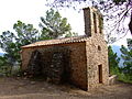
Ermita de Sant Salvador
_-_1.jpg)


literature
- Vicenç Buron: Esglésies Romániques Catalanes. Artestudi Edicions, Barcelona 1977, p. 91, ISBN 84-85180-06-2 .
Web links
- Súria, church - information (spanish)
Individual evidence
- ↑ Cifras oficiales de población resultantes de la revisión del Padrón municipal a 1 de enero . Population statistics from the Instituto Nacional de Estadística (population update).
Aguilar de Segarra | Artés | Avinyó | Balsareny | Callus | Cardona | Castellbell i el Vilar | Castellfollit del Boix | Castellgalí | Castellnou de Bages | Fonollosa | Gaià | Manresa | Marganell | Monistrol de Montserrat | Mura | Navarcles | Navàs | El Pont de Vilomara i Rocafort | Rajadell | Sallent | Sant Feliu Sasserra | Sant Fruitós de Bages | Sant Joan de Vilatorrada | Sant Mateu de Bages | Sant Salvador de Guardiola | Sant Vicenç de Castellet | Santpedor | Súria | Talamanca