Freienthal
|
Freienthal
Community Planebruch
Coordinates: 52 ° 13 ′ 48 ″ N , 12 ° 43 ′ 3 ″ E
|
|
|---|---|
| Height : | 47 m above sea level NHN |
| Area : | 5.27 km² |
| Residents : | 88 |
| Population density : | 17 inhabitants / km² |
| Incorporation : | 1st February 1974 |
| Incorporated into: | Damelang-Freienthal |
| Postal code : | 14822 |
| Area code : | 033844 |
|
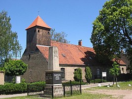
Village church and war memorial in Freienthal
|
|
Freienthal is a part of the municipality of Damelang-Freienthal , a district of the administrative municipality of Planebruch in the Potsdam-Mittelmark district in Brandenburg . Between February 1, 1974 and January 31, 2002, Freienthal was part of what was then the municipality of Damelang-Freienthal, previously the place was an independent municipality.
location
Freienthal is located in the Hoher Fläming Nature Park on the edge of the Belziger landscape meadows , about five kilometers northwest of Brück and 24 kilometers as the crow flies southeast of the city of Brandenburg an der Havel . Surrounding villages are Damelang in the north, Borkwalde and Borkheide in the east, the town bridge in the southeast, Trebitz in the south, to the city of Bad Belzig related districts Fredersdorf and Lütte in the southwest, Dippmannsdorf and Ragösen in the West as well as to the community Golzow belonging abode Mügge mountain in Northwest.
State road 85 runs through the village from Golzow via Brück to Treuenbrietzen . This connects the place to the federal highway 9 (junction Beelitz and Brück). Freienthal borders the Lehnin military training area in the east . Except in the west, the village is completely surrounded by forest. From Freienthal there are four bus routes to Bad Belzig, Golzow, Brück and Treuenbrietzen.
The Hackhausen residential area belongs to Freienthal . The tarpaulin flows southwest of the village .
history
Freienthal is a typical street village . It was laid out as a spinner village from 1754 under the direction of Friedrich II. On the district of Damelang. The name of the place derives from the fact that the colonists of the village did not have to pay any taxes at times .
In 1784 the school and prayer house was built. Until then, services were held in the village head's house. A small tower was added to this in 1792, the exterior of the building resembles the existing residential area. In contrast to the surrounding villages, Freienthal belonged to Prussia and not to the Kingdom of Saxony until 1815 . After that, Freienthal was in the newly formed district of Zauch-Belzig in the administrative district of Potsdam in the province of Brandenburg . According to the topographical-statistical overview of the administrative district of Potsdam and the city of Berlin from 1841, the Freienthal colony had 300 inhabitants and 53 residential buildings that year. The church is a branch church of the Neuendorf village church . At that time, Freienthal was part of Lehnin .
After the Second World War, Freienthal became part of the Soviet occupation zone and later the GDR . During the territorial reform carried out in the GDR in July 1952, the municipality of Freienthal was assigned to the Belzig district in the Potsdam district . In the 1960s, the building used as a church was renovated for the first time. On February 1, 1974, the Freienthal community merged with the Damelang community to form the new Damelang-Freienthal community. After the fall of the Wall , the Belzig district was renamed the Belzig district and finally dissolved. During the district reform in December 1993 , the Damelang-Freienthal community was assigned to the new Potsdam-Mittelmark district . On January 31, 2002, the community merged with the community of Cammer to form the new community of Planebruch . In 2019, the church, which was partially in need of renovation, was renovated again.
Population development
| Population development in Freienthal from 1875 to 1971 | |||||||||||||||||||
|---|---|---|---|---|---|---|---|---|---|---|---|---|---|---|---|---|---|---|---|
| year | Residents | year | Residents | ||||||||||||||||
| 1875 | 315 | 1939 | 268 | ||||||||||||||||
| 1890 | 306 | 1946 | 436 | ||||||||||||||||
| 1910 | 253 | 1950 | 365 | ||||||||||||||||
| 1925 | 274 | 1964 | 285 | ||||||||||||||||
| 1933 | 295 | 1971 | 269 | ||||||||||||||||
Web links
- Damelang and Freienthal in the RBB program Landschleicher on February 12, 1995
Individual evidence
- ↑ Reinhard E. Fischer : The place names of the states of Brandenburg and Berlin. Age - origin - meaning . be.bra Wissenschaft, Berlin 2005, p. 57 .
- ↑ a b Bärbel Kraemer: A Beethaus with a very special story. In: Märkische Oderzeitung , September 23, 2019, accessed on October 1, 2019.
- ↑ Topographical and statistical overview of the administrative district of Potsdam and the city of Berlin . Verlag der Gander'schen Buchhandlung, Berlin 1841, p. 85 ( zlb.de ).
- ^ Freienthal in the historical index of places. Retrieved July 16, 2018 .
- ^ Historical municipality register of the state of Brandenburg 1875 to 2005. (PDF; 381 KB) Potsdam-Mittelmark district. State Office for Data Processing and Statistics State of Brandenburg, December 2006, accessed on July 16, 2018 .
