
Freudeneck (Rattelsdorf)
|
Freudeneck
market Rattelsdorf
Coordinates: 50 ° 2 ′ 9 ″ N , 10 ° 52 ′ 49 ″ E
|
|
|---|---|
| Height : | 247–260 m above sea level NN |
| Residents : | 38 (2018) |
| Postal code : | 96179 |
| Area code : | 09547 |

Freudeneck is a district of the Rattelsdorf market in the Upper Franconian district of Bamberg with 38 inhabitants.
geography
Freudeneck is on the Itz . Neighboring towns are Helfenroth and Medlitz (both Markt Rattelsdorf) in the north, Unterbrunn (Markt Ebensfeld , Lichtenfels district ) in the northeast, Unterleiterbach (Markt Zapfendorf) in the east, Zapfendorf in the southeast, Höfen and Rattelsdorf in the south and Zeitzenhof and Untermanndorf in the west. The Franconian Marienweg runs through the village .
history
Freudeneck was first mentioned in a document in 1376 when Albrecht von Lichtenstein and Karl Fuchs had received a farm in the "Fröudeneck" district. Until 1972, the place belonged to the dissolved district of Ebern and thus to Lower Franconia . In 1978 Freudeneck was incorporated into the Rattelsdorf market as part of the municipality of Höfen with Höfenneusig.
brewery
The Fischer brewery is located in Freudeneck. With its 36 inhabitants, Freudeneck is the smallest town in the Bamberg district with a brewery.
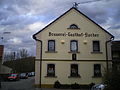
Fischer brewery

Maria Queen Chapel (inauguration 1992)
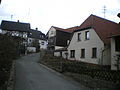
Town center

Itz floods in February 2010

Rural property


Burgstall
The Burgstall Freudeneck is located in the Daschendorfer Forest west of the village .
literature
Jungkunz, Manfred: Heimatbuch Höfen-Höfenneusig-Freudeneck, gem in Itzgrund. Mediengruppe Oberfranken, Druckereien GmbH & Co. KG, 2017
Web links
Individual evidence
- ↑ Population of the districts of Rattelsdorf
- ^ Werner Schmiedel: Districts Ebern and Hofheim . Historical book of place names of Bavaria. Lower Franconia. Volume 2: Districts of Ebern and Hofheim. Commission for Bavarian History, Munich 1973, ISBN 3 7696 9872 X . P. 13

Busendorf | Ebing | Freudeneck | Helfenroth | Hilkersdorf | Courtyards | Höfenneusig | Medlitz | Mürsbach | Poppendorf | Rattelsdorf | Speiersberg | Zaugendorf