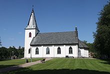
Gånghester and Målsryd
| Gånghester and Målsryd | ||||
|
||||
| State : | Sweden | |||
| Province (län): | Västra Götalands län | |||
| Historical Province (landskap): | Västergötland | |||
| Municipality : | Borås | |||
| Coordinates : | 57 ° 42 ' N , 13 ° 3' E | |||
| SCB code : | 4848 | |||
| Status: | Crime scene | |||
| Residents : | 2533 (December 31, 2015) | |||
| Area : | 2.73 km² | |||
| Population density : | 928 inhabitants / km² | |||
| List of perpetrators in Västra Götaland County | ||||
Gånghester och Målsryd is a place ( Tatort ) in the municipality of Borås in the Swedish province of Västra Götalands län and the historical province (landskap) Västergötland .
The place extends about five to nine kilometers southeast of the center of the main town of the municipality, the city of Borås . Before 2015, the districts of Gånghester and Målsryd, which are about 2.5 kilometers apart, were separate Tatorte. Gånghester, to the northwest, closer to Borås, had 1526 inhabitants last (2010), Målsryd 907.
Originally the Riksväg 27 ran between Växjö and Borås (today further to Gothenburg ) on a winding route through the town. However, since it was re-routed in the 2000s, it has been bypassed extensively to the south.
The Borås– Alvesta section of the Kust till kust-banan railway runs past Gånghester och Målsryd and connects Gothenburg with Kalmar across southern Sweden . However, the train stations in both districts are out of service, as is the line in the direction of Ulricehamn - Jönköping that formerly branched off at Gånghester , which was closed in 1986 and subsequently dismantled.
Sons and daughters of the place
- Patrik Järyn (* 1969 in Målsryd), ski racer
- Joakim Sjöhage (* 1986 in Målsryd), football player
Web links
Individual evidence
- ↑ a b c Statistiska centralbyrån : Land area per crime scene, folkmängd och invånare per square kilometer. Vart femte år 1960 - 2015 (database query)

