
Günthers
|
Günthers
City of Tann (Rhön)
Coordinates: 50 ° 39 ′ 30 ″ N , 9 ° 59 ′ 32 ″ E
|
|
|---|---|
| Height : | 346 m above sea level NHN |
| Area : | 2.65 km² |
| Residents : | 428 (Dec. 31, 2013) |
| Population density : | 162 inhabitants / km² |
| Incorporation : | December 31, 1971 |
| Postal code : | 36142 |
| Area code : | 06682 |
Günthers in der Rhön is a district of Tann (Rhön) in the eastern Hessian district of Fulda .
It is located on the B 278 between Motzlar and Tann and on the Ulster River .
history
It was first mentioned in 1362 as a settlement on Reichsstrasse and was part of the fiefdom of the Fulda monastery .
Since Günthers belonged to the Tann rule (in the knightly canton of Rhön-Werra, Buchisches Quartier), the Reformation was probably introduced around 1540.
On December 31, 1971, the previously independent municipality was incorporated into the city of Tann.

The Ulster in Günthers with Mühlgraben

Students and teachers at Günthers elementary school in 1927
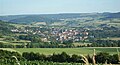
Tann (Rhön) seen from Günthers

The Rockenstuhl seen from Günthers.
_Tann.JPG)
.jpg)


Web links
- Internet presence of the city of Tann (Rhön)
- Günthers, district of Fulda. Historical local dictionary for Hessen. In: Landesgeschichtliches Informationssystem Hessen (LAGIS).
Individual evidence
- ↑ Statistical figures on the website of the city of Tann (Rhön) , accessed in February 2016.
- ↑ Population statistics of the Fulda district , accessed in September 2015.
- ^ Federal Statistical Office (ed.): Historical municipality directory for the Federal Republic of Germany. Name, border and key number changes in municipalities, counties and administrative districts from May 27, 1970 to December 31, 1982 . W. Kohlhammer GmbH, Stuttgart / Mainz 1983, ISBN 3-17-003263-1 , p. 394 .
Core town Tann (Schweidhof, Friedrichshof , Hasenmühle) - Günthers
Habel (Esbachsgraben, Neustädtges, Habelgraben, Schwarzenborn , Karnhof, Mollartshof)
Hundsbach ( Dippach , Kleinfischbach , Herdathurm) - Lahrbach (Brauertshof, Paradieshof)
Neuschwambach (Altschwambach, Aura, Oberrückersbach) - Neuswarts (sea winds)
Schlitzenhausen (Sinslösungen) -
Theobaldshof (Knottenhof, Dietgeshof ) - Wendershausen (Rothof)