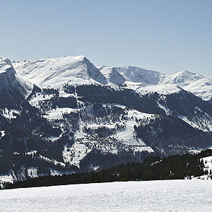
Gurgaletsch
| Gurgaletsch | ||
|---|---|---|
|
View from the Hochwanghütte |
||
| height | 2441 m above sea level M. | |
| location | Graubünden , Switzerland | |
| Mountains | Plural pen | |
| Dominance | 1.7 km → Tschingla | |
| Notch height | 144 m ↓ notch north of Malakoff | |
| Coordinates | 763 661 / 185127 | |
|
|
||
| rock | Chalk and Malm limestone | |
The Gürgaletsch with 2441 m above sea level. M. is a mountain in the canton of Graubünden in Switzerland .
location
The Steinmann-crowned summit of the Gürgaletsch is the northernmost rock head of the mountain range in the Central Plessuralpen , which runs from the Parpaner Rothorn to the Churer Joch. Like its two neighbors, Alpstein and Chli Gürgaletsch, the Gürgaletsch appears as a desk-shaped elevation, especially from the north: Alpine pastures from the east to the ridge, imposing rock faces to the northwest. Its mountain structure is extremely complicated. Its rock consists of chalk and Malm limestone from the Falknis / Sulzfluh cover.
The direction and distance to Gürgaletsch from the following places:
Parpan - 25 ° - 4,421 km,
Churwalden - 56 ° - 3,456 km,
Malix - 114 ° - 4,347 km,
Chur Bhf. - 144 ° - 7,478 km,
Maladers - 157 ° - 4,716 km km,
Inner-Praden - 177 ° - 3,100 km,
Calfreisen - 189 ° - 5,010 km,
Castiel - 196 ° - 4,823 km,
Tschiertschen - 217 ° - 2,961 km,
St. Peter - 227 ° - 6,244 km.
The Gürgaletsch can also be called Tschiertschen's local mountain.
Ascent
- from Tschiertschen to Farur then Weglos over the eastern flank
- from Tschiertschen via Farur-Obersäss to the south ridge
- from Tschiertschen to Farur via Hüenerchöpf and the Tälli to the south ridge
- from Parpan to the Churer Joch and the Tälli to the south ridge
- from Parpan to Oberberg then Weglos to the south ridge
Adjacent peaks
- Alpstein 2298 m - 1,372 km - (97 °)
- Tschingla 2449 m - 1,713 km - (130 °)
- Parpaner Schwarzhorn 2683 m - 2,716 km - (156 °)
- Stelli 2417 m - 0.852 km - (181 °)
- Täliflue 2301 m - 0.586 km - (264 °)
- Chli Gürgaletsch 2279 m - 0.639 km - (281 °)
- Churer Joch 2033 m - 1,587 km - (319 °)
cards
- National map of Switzerland 1: 25,000, sheet 1196 Arosa ,
- National map of Switzerland 1: 50,000, sheet 248 Prättigau .
literature
- Manfred Hunziker: Ringelspitz / Arosa / Rätikon , Alpine Tours / Bündner Alpen , Verlag des SAC 2010, ISBN 978-3-85902-313-0 , p. 284.
- Manfred Hunziker: "Bündner-Alpen-1 Tamina and Plessur Mountains" Swiss Alpine Club ISBN 3-85902-048-X .
Web links
Individual evidence
- ↑ Source: Geology of Schanfigg - Prof. Conradin A. Burga

