Garder See (Lohmen)
| Garder lake | ||
|---|---|---|

|
||
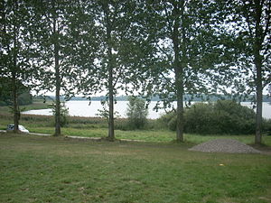
| Lake Garder seen from the north shore | ||
| Geographical location | Rostock district | |
| Tributaries | Bresenitz , Bollbach and various trenches | |
| Drain | Bresenitz to the Woseriner See | |
| Places on the shore | Garden | |
| Data | ||
| Coordinates | 53 ° 41 '2 " N , 12 ° 3' 36" E | |
|
|
||
| Altitude above sea level | 37.8 m above sea level NHN | |
| surface | 1.05 km² | |
| Maximum depth | 15.5 | |
| Middle deep | 5.0 | |
The Garder See is located in the Sternberg lake landscape about two kilometers west of Lohmen in the Rostock district in Mecklenburg-Western Pomerania .
description
The natural lake is a maximum of 1.2 kilometers long (with the southern bay 1.6 kilometers) and 1.2 kilometers wide and thus covers an area of around 105 ha .
It is located in a charming, natural, hilly terminal moraine landscape in the Mittleres Mildenitztal landscape protection area . On the shore there are three smaller districts of the municipality of Lohmen with Althagen in the south, Garden in the north and Garder Mühle in the west. The lake is very indented and has several distinctive bays. The southern bay is almost separated from the rest of the lake by a small island. The Bresenitz also flows into the lake here.
The following lakes are in the vicinity: Mühlensee (1.9 km), Lähnwitzer See (2.3 km), Lohmener See (2.3 km), Hollensee (2.7 km) and Nienhagener See (2.7 km).
history
The Garder See was mentioned in a document as See Gardene when the Dobbertiner monastery was expanded in 1237 . In this document, Mr. zu Werle and Rostock Nikolaus confirmed the boundaries of the monastery area.
The outflow of the lake was created by an artificial puncture of the area to the Woseriner See . Here is the small settlement of Garder Mühle , whose name refers to the operation of a water mill from 1263 to 1828.
From 1725 to 1727 Adam Langermann from Klein Upahl sued the monastery office because of quarrels about fishing on Lake Garda. The lease contract concluded with the fisherman Koebcke from Dobbertin until 1899 was extended to 1905.
Since 1970, the development of the Garder See into a tourist location began. First a children's holiday camp was set up and then a community-owned campground was set up. This was followed by the construction of corporate and private holiday homes.
After German reunification and the establishment of the state of Mecklenburg-Western Pomerania in 1990, the recreational facilities were completely renovated and funded by the municipality of Lohmen.
The rehabilitation clinic Garder See GmbH opened near the lake in 1996 on the site of the former holiday camp and a new campsite was built on the north bank.
fauna and Flora
On the shores of the lake, reed beds as high as a man and bulrushes have settled and form an average five meter wide belt. These water-loving plants are followed inland by alders and willows .
Eels , perch , bream , pike , roach , tench and pikeperch have been and are being caught in the lake .
use
There is an official bathing area in the Garden district and there are also numerous free, unsupervised accesses to the lake. The lake is also used by a local fisherman who primarily supplies regional hotels and restaurants with fresh fish. The fishing farm Geibrasch in Lohmen issues guest fishing permits.
See also
cards
- Mecklenburg, atlas of Hoinckhusen around 1700.
- Wiebeking map of Mecklenburg 1786.
- Economic map of the Dobbertin Forestry Office 1827/1928.
- Official cycling and hiking map of the Nossentiner / Schwinzer Heide nature park 2010.
Web links
literature
- Wilhelm Mastaler: The watermills of the Güstrow district and their history. Güstrow 1990, pp. 149-162.
- Hartmut Hoffmann: Spa and Rehabilitation Center Lohmen. In: Güstrower Jahrbuch. Volume 9, 2000, pp. 238-241.
swell
Printed sources
- Mecklenburg record book (MUB)
Unprinted sources
-
State Main Archive Schwerin (LHAS)
- LHAS 1.5-4 / 3 documents Dobbertin monastery.
- LHAS 3.1-3 / 1 Provincial Monastery / Monastery Office Dobbertin.
Individual evidence
- ↑ a b c d Water profile on anglermap.de , accessed on August 11, 2020.
- ↑ MUB I. (1863) No. 469.
- ^ Wilhelm Mastaler: The Garder mill, place of Garden. 1991, p. 149.
- ↑ LHAS 3.2-3 / 1 Landeskloster / Klosteramt Dobbertin. No. 643 Management of the Lakes.
- ↑ LHAS 5.11-2 Minutes of the Landtag. 1998, No. 9.
- ↑ Mecklenburg. Atlas by Bertram Christian von Hoinckhusen around 1700. Published by the Mecklenburg-Western Pomerania Land Survey Office, Schwerin 1995.
