
Regional division of Frankfurt (Oder)
The area of the city of Frankfurt (Oder) is structured according to a hierarchical system. As of 2008, the five districts of the city center, Beresinchen, North, West and South, are divided into 32 urban areas, these into 84 residential districts, these into around 800 building blocks and these into around 3,000 block sides. Frankfurt (Oder) includes 32 districts, community parts and other settlement areas .

I - city center, II - Beresinchen, III - North, IV - West, V - south
Downtown district
City center area

Regional division of Frankfurt (Oder) s, location of the city center highlighted

City center boundaries and residential districts

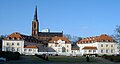
View from Oderturm to the north towards the city center

_Map.svg)

The city center city center has around 4,250 inhabitants, who are on average 44 years old (2005). The 89 meter high Oderturm is the dominant height . The Marienkirche , the Friedenskirche , the concert hall , the city museums and the town hall are also worth seeing. Three buildings of the European University Viadrina , the main building, the Audimax and the Gräfin-Dönhoff building are also located in the center. The city bridge is a symbol of the twinning with Słubice . In addition to the neighboring island of Ziegenwerder , the Lennépark is also part of the green spaces in the center.
Stadtmitte forms with the Friedenskirche and the Marienkirche the oldest core of the city. It consists of the residential districts 111: Oderpromenade , 112: Zentrum , 113: Lennépark , 114: Alte Uni and 115: Friedenskirche .
In the north it is bordered by the northern end of Halbe Stadt street and, as an extension, by Kiezer Gasse; in the east of the Oder, which is also the eastern border of Brandenburg and Germany to Poland. The city center is bounded by Logenstrasse in the south and Heilbronner Strasse in its extension, and Halbe Stadt Strasse in the west.
Urban area of Gubener Vorstadt

Regional division of Frankfurt (Oder) s, location of the Guben suburb highlighted

Limits and residential areas of the Guben suburb
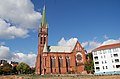
View from the Anger to the north of the residential buildings designed by Martin Kießing and St. Gertraud


_30.jpg)
About 2,900 inhabitants (2005) live in the urban area of Gubener Vorstadt . The district is located between Buschmühlenweg and Güldendorfer Straße. The historic building of the municipal waterworks and the residential buildings not far from the St. Gertraud church are worth seeing.
The Guben suburb is located south of the historic town center on the road to Guben and consists of the residential districts 121: Bahnhofsberg , 122: Klenksberg , 123: Fischerkietz and 124: Oderwiesen .
In the north it is bordered by Heilbronner and in the extension by Logenstraße; in the east of the Oder, which at the same time forms the eastern border of Brandenburg and Germany with Poland. From the railway bridge in the south-east, the railway line to Poland borders the Gubener Vorstadt area in the south and west, and Leipziger Strasse in the north-west.
City area Half city
Catholic Church of the Holy Cross
.jpg)
The urban area of Halbe Stadt consists of the residential districts 131: Catholic Church , 132: Kleistforum , 133: Gursches Stift , 134: Thomas-Müntzer-Hof , 135: Weißes Rössel , 136: Lienaupark and 137: Bruno-Peters-Berg .
City area Upper City
The urban area Obere Stadt consists of the residential districts 141: Wildenbruch , 142: Botanical Garden , 143: Kleistpark and 144: Huttenviertel .
Beresinchen district
City area Altberesinchen

Regional division of Frankfurt (Oder) s, location of Altberesinchens highlighted

Limits and residential areas of Old Beresin

Tram Tatra KT4 line 3 to the stadium on Dresdner Platz


Around 5,000 people live in the Altberesinchen urban area . The district emerged after 1874 after the opening of the Berlin-Frankfurt railway line north of Müllroser Strasse. Was inhabited Beresinchen mainly of workers and employees of the railway company. The streets and squares are mainly named after cities and towns.
Altberesinchen consists of the residential districts 211: Marienbad , 212: Dresdener Platz , 213: Luckauer Dreieck , 214: Schwänchenteich , 215: Yellow Press and 216: Winzerring .
Urban areas Neuberesinchen / North and Neuberesinchen / South

Regional division of Frankfurt (Oder) s, location of Neuberesinchen highlighted

Limits and residential areas of Neuberesinchens

View over Neuberesinchen


The urban areas of Neuberesinchen / North and Neuberesinchen / South were not built on until 1977, making them the youngest urban areas in Frankfurt. The urban areas, the population of which fell by over 50 percent between 1989 and 2005, are the most populous in Frankfurt with 10,250 inhabitants. The urban areas are dominated by prefabricated buildings, many of which were demolished in the 2000s. One of the oldest buildings is the water tower. At the edge of the urban area there is an approximately 100 meter high radio tower , which was renovated in 2002.
Neuberesinchen is located south of the Altberesinchen district and consists of the residential districts 221: Spartakusring , 222: Kommunardenweg , 223: Auroraügel , 224: Schluchtweg , 225: Clara-Zetkin-Ring , 226: Am Arboretum and 227: Jungclaussen (North) and 228: Lutherstift , 231: Schulsternwarte , 232: Am Mühlental , 233: Schwedenschanze , 234: Fröbelpromenade , 235: Obere Thomasiusstraße , 236: Untere Thomasiusstraße , 237: radio tower and 238: Wilhelmshöhe (south).
Güldendorf urban area

Regional division of Frankfurt (Oder) s, location Güldendorf highlighted

Limits Güldendorf

Seestrasse in Güldendorf


Güldendorf was first mentioned in 1230 in the list of privileges of the Moritz monastery in Halle as Cessonovo. By order of the Soviet city command, Güldendorf belonged to the Frankfurt (Oder) district from 1945. The municipal council decided the incorporation on October 27, 1946; on October 29, 1947 Güldendorf was assigned to the city of Frankfurt.
The district of Güldendorf is located south of Neuberesinchens and the Guben suburb. In a clockwise direction, the district bounds in the north from the crossing of Eisenhüttenstädter Chaussee via the autobahn, the autobahn itself, the railway line to Müllrose, an allotment garden and the railway line to Poland to the border station, in the east the Oder, in the southeast the Viehtrift path to the railway line to Eisenhüttenstadt, in the south from the southeast the railway line to Eisenhüttenstadt up to Lindenstrasse, Lindenstrasse itself and its extension to the southwest to the confluence of Güldendorfer Weg with Eisenhüttenstädter Chaussee, then to the west in a straight line to the railway line to Müllrose. In the west, the railway line to Müllrose and Eisenhüttenstädter Chaussee mark the boundaries.
City of Lossow

Regional division of Frankfurt (Oder), Lossow's location highlighted

Limitations of Lossow. 206: Lossow and Helenesee
House and church tower in Lossow


Lossow was first mentioned in a document in 1328. In 1816 Lossow joined the Frankfurt (Oder) district when the Brandenburg Province was formed . In 1952 it was assigned to the Fürstenberg (Oder) district (later Eisenhüttenstadt-Land ). 1973 Lossow becomes part of Frankfurt (Oder).
The district of Lossow becomes clockwise from the crossing Lindower Weg and the railway line to Müllrose from the railway line to Müllrose, then from a straight line north of the Küstriner Berg allotment garden and the gravel pit to the confluence of Güldendorfer Weg with Eisenhüttenstädter Chaussee, then to the northeast bounded by a straight line to Lindenstrasse, Lindenstrasse itself to the railway line to Eisenhüttenstadt and then by the railway line to Eisenhüttenstadt to the Viehtrift path. Then the cattle trail shows the border to the north, followed by the course of the Oder to the southwest of Rybocice, the border zigzagging to the northwest to the shore of Lake Brieskower. Then the border follows the eastern bank of the Brieskower See to the northwest and then the western bank to the south, in order to extend the course of the border from the Oder in an arc to the southwest south of the youth shaft to the Eisenhüttenstädter Chaussee (B112) cross and run north of the ash pit and the Margarethensiedlung to the Katja lake. In the Katjasee the border zigzag to the south, turns on the south bank to the west and extends south of the Helenesees in several hooks to the Kaisermühler Weg, west of which it then runs north to the level of the middle of the west bank. From there, the border runs to the northwest to the crossing of Lindower Weg and the railway line to Müllrose.
North district
Urban area of Lubusz suburb

Regional division of Frankfurt (Oder) s, location of the Lebuser suburb highlighted

Limits of the Lubusz suburb. 702: Seelower Kehre, 707: Schlachthof / Klärwerk, 708: Klingestraße, 709: Bergstraße

Triftweg


_23.jpg)
In 2005, the urban area of Lubusz suburb was inhabited by around 3,457 inhabitants on an area of 320 hectares. At 31 percent, the 30- to 49-year-old age group is high and makes up for the majority of the city's total population. The area includes multi-storey, single-family and terraced apartments as well as industrial areas. From 1970 to 1975, prefabricated buildings were built in the Seelower Kehre ; later development of gaps in Bergstrasse .
The Lebuser suburb is located north of the historical city center and consists of the residential districts 311: Seelower Kehre , 312: Neue Welt , 313: Noacks Teich and 314: Bergstraße Ost .
City area Hansa Nord

Regional division of Frankfurt (Oder) s, location of the Hansaviertel highlighted

Limits of the Hansaviertel. 703: Caritas retirement home, 706: Hansa-Siedlung, 710: Moskauer Straße, 711: Warschauer Straße, 712: Sports facilities / Spitzkrugmulticenter

View View from Beckmannstrasse to the Hansaviertel


_42.jpg)
Around 5,000 people (2005) live in Hansa Nord (also Hansa-Nord or Hansaviertel ), around half of which are older than 50 years. The quarter was not settled until 1930 when the first villas were built there. The GDR housing program was implemented between 1971 and 1976, and numerous prefabricated houses were built . There were also department stores , sports facilities , a retirement home and a youth club. The ASK Vorwärts Frankfurt sports club has also been based in this quarter since 1973 . Today the Olympic base, the sports promotion group of the Bundeswehr and next to it the sports school are located there .
The Hansaviertel consists of the residential districts 321: Bergstrasse West , 322: Hansaviertel , 323: Finkensteig , 324: Sportschule and 325: Spitzkrug .
Klingetal urban area

Regional division of Frankfurt (Oder) s, Klingetals location highlighted

Limitations of Klingetal. 801: Klingetal settlement

Heilandskapelle


_003.jpg)
In Klingetal about 820 inhabitants live on an area of 130 ha. The proportion of 41 to 65 year olds predominates, with the 50 to 64 year old group being particularly high. From the beginning of the First World War until 1919 there was a camp in the Klingetal for prisoners of war from different nations. In 1921, relocated optants from Posen , West Prussia and Upper Silesia settled in the former camp . At times there was also accommodation for Volga Germans who, however, only used the camp as a transit station. In 1924 the remaining refugees founded the homecoming settlement . The excellent green area to the blade led to further settlement in the 1930s and after the fall of the Wall . In a comparison of all urban areas, the proportion of apartments grew the most with 33 percent compared to 1995.
City area Kliestow

Division of Frankfurt (Oder) s, location of Kliestows highlighted

Limits of Kliestow. 802: Kliestow
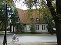
Former school in Kliestow


Boossen urban area

Regional division of Frankfurt (Oder) s, location Boossen highlighted

Former Boossen manor


West district
Nuhnenvorstadt urban area

Regional division of Frankfurt (Oder) s, location Nuhnenvorstadt highlighted

Theater pond


The Nuhnenvorstadt district , commonly known as West , with an area of 630 hectares is inhabited by around 6,800 people. The area is bordered by the Markendorfer, Lichtenberger and Schubertstraße. The name Nuhnen comes from the Slavic Nutnica and means farm, sheep farm, estate . Up until the 1920s there were only barracks in this area. The plans for the original development came from Hans Bernoulli and were used by Martin Kießling , the Reichsbahnbaurat for the creation of the Paulinenhof garden settlement . The district was badly damaged by the Second World War .
The Nuhnenvorstadt consists of the residential districts 411: Großnuhnen , 412: Rote Kaserne , 413: Westkreuz / Seefichten , 414: Paulinenhof and 415: Yellow Kaserne .
City area Rosengarten / Pagram

Regional division of Frankfurt (Oder) s, location Rosengarten / Pagram highlighted

Frankfurt (Oder) -Rosengarten station

-Rosengarten_Bushaltestelle.jpg)
City of Lichtenberg

Regional division of Frankfurt (Oder) s, Lichtenberg location highlighted

Bismarck Tower


South district
Urban area winegrowers' quarter
The Winzerviertel district consists of the residential districts 511: Neuer Wasserturm , 512: Am Hauptfriedhof , 513: Stakerweg , 514: Lokbad , 515: Beerenweg , 516: Kräuterweg and 517: Langer Grund .
Urban area cosmonaut district
The Kosmonautenviertel district consists of the residential districts 521: Südring , 522: Gagarinring , 523: Baumschulenweg , 524: Keplerweg , 525: Römerhügel and 526: Kopernikusstraße .
Nuhnen urban area
The Nuhnen district consists of the residential districts 531: Gartenstadt , 532: ETTC-Nordost , 533: Am Großer Dreieck and 534: Nuhnen-West .
Markendorf city area

Regional division of Frankfurt (Oder) s, Markendorf location highlighted

Brandendorf


City area of the Markendorf settlement

Regional division of Frankfurt (Oder) s, Markendorf settlement highlighted

Markendorf settlement consists of the residential districts 551: Markendorf settlement and 552: ETTC-Süd .
Urban area Hohenwalde

Regional division of Frankfurt (Oder) s, Hohenwalde location highlighted

Hohenwalde Church


Web links
- Small-scale structure of the city of Frankfurt (Oder). (PDF, 3.61 MB) Representation based on the automated property map (ALK) of the city of Frankfurt (Oder). In: frankfurt-oder.de. Cadastre and Surveying Office Land Management and Local Surveying Department of the City of Frankfurt (Oder), 2008, accessed on July 11, 2016 .
Individual evidence
- ↑ Bak: Explanations on the small-scale structure of the city of Frankfurt (Oder). (PDF; 92.6 kB) City of Frankfurt (Oder), March 27, 2009, accessed on December 24, 2016 .
- ↑ Märkische Oderzeitung / Frankfurter Stadtbote, 23 August 2005, p. 13
- ↑ Märkische Oderzeitung / Frankfurter Stadtbote, October 11, 2005, p. 13
- ↑ Märkische Oderzeitung / Frankfurter Stadtbote, August 16, 2005, p. 13
- ↑ Märkische Oderzeitung / Frankfurter Stadtbote, August 30, 2005, p. 16
- ↑ Märkische Oderzeitung / Frankfurter Stadtbote, August 2, 2005, p. 13
- ↑ Heilandskapelle ( page no longer available , search in web archives ) Info: The link was automatically marked as defective. Please check the link according to the instructions and then remove this notice.
- ↑ History of the Heilandskapelle ( Memento of the original from March 3, 2016 in the Internet Archive ) Info: The archive link was inserted automatically and has not yet been checked. Please check the original and archive link according to the instructions and then remove this notice.
- ↑ Märkische Oderzeitung / Frankfurter Stadtbote, August 9, 2005, p. 13