
Gentzgasse
| Gentzgasse | |
|---|---|
|
|
|
 |
|
| Gentzgasse at Aumannplatz | |
| Basic data | |
| place | Vienna |
| District | Currency ring |
| Created | 12th century at the latest |
| Hist. Names | Herrengasse |
| Name received | 1894 |
| Connecting roads | Sechsschimmelgasse (east), Wallrißstrasse (west) |
| Cross streets | Semperstrasse, Kutschkergasse, Edelhofgasse, Riglergasse, Martinstrasse, Gymnasiumstrasse, Weimarer Strasse , Cottagegasse, Argauergasse, Dittesgasse, Lazaristengasse, Türkenschanzstrasse, Köhlergasse, Innozenz-Lang-Gasse, Weinhauser Gasse, Simonygasse, Bäckenbrünnlgasse |
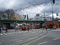
| Places | Aumannplatz |
| Subway stations | Währinger Straße underground station |
| use | |
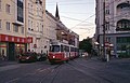
| User groups | Pedestrians , bicycle traffic , motorized individual traffic , tram lines 40, 41 |
| Technical specifications | |
| Street length | approx. 1,690 m |
The Gentzgasse leads from the belt up to Vorortelinie and Gersthoferstraße by the 18th Viennese district of Währing .
history
Gentzgasse is an old street, which in the lower area (up to today's Aumannplatz) formed the northern boundary of the village of Währing (mentioned in a document in 1161/76); the southern limit was the Währinger Strasse . Until the second quarter of the 19th century, Gentzgasse between Semperstraße and Gymnasiumstraße was built on both sides with one and two-story houses from the Baroque and Biedermeier periods . From the third quarter of the 19th century, the building extended to Türkenschanzstrasse (the border to Weinhaus ). The road in Weinhaus was not built until the end of the 19th century.
Weinhaus and Währing were traversed by the Währingerbach ; it followed today's streets Pötzleinsdorfer Strasse - Gersthofer Strasse - Gentzgasse - Aumannplatz - Währinger Strasse and flowed into the Alserbach in the Alsergrund district . From 1848 to 1901 the stream was gradually vaulted.
When the decision to incorporate the suburbs into Vienna was decided in 1890, the street in both Weinhaus and Währing was called Herrengasse . By resolution of the Vienna City Council on July 18, 1894, the name Gentzgasse (after Friedrich von Gentz , who had had his summer residence in the so-called Gentz-Schlössel in Währinger Strasse 169-171 since 1815) was awarded.
From October 1899, the horse-drawn tram , which had led through Währinger Strasse to Aumannplatz since 1884, was extended across the square through Gentzgasse to Gersthofer Strasse. It was operated as an electric tram since January 1902.
description
Course, characteristics
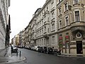
Gentzgasse begins at Währinger Gürtel and runs in several flat arcs, but generally in a west-northwest direction to Gersthofer Straße. To the south of it, Währinger Strasse runs largely parallel at a distance of one block. At the beginning (No. 2, 4, 10) remains of the Biedermeier or older buildings are still preserved; Otherwise, the building fabric consists mainly of three- to four-storey rental houses from the periods of Viennese historicism and the Vienna Secession , with individual buildings from the interwar and postwar period. At the intersection with Martinstrasse and Gymnasiumstrasse, on the left hand side, is the administrative building for the 18th district, built in the style of the German Renaissance. At Aumannplatz, Währinger Strasse and Gentzgasse come closest to one another; The square itself is home to the Norbert Liebermann Park, the only larger green area along the street. The north side of the square is dominated by the historic St. Carolus home. In the further course the street in front of the Weinhauser Church widens like a square (house numbers 123 and 125). Finally, Gentzgasse crosses under the viaduct of the suburb line and ends at the oblique intersection with Gersthofer Straße.
traffic
Gentzgasse provides a connection from the 9th district and, in a broader sense, from the city center to the western parts of Währing ( Gersthof , Pötzleinsdorf ). It is as Main Street A classified.
For traffic with motor vehicles , Gentzgasse can be driven in its entire length in the direction of travel out of town, so that it fulfills the connection function described above all in this direction. In the last section, however, it is a one-way street both in the area of Aumannplatz and from Weinhauser Gasse to Gersthofer Straße, so that private motorized traffic is initially directed towards the city center through Währinger Straße and can only change over to Gentzgasse at Aumannplatz. The only exception to this is the tram, which runs on Gentzgasse between Gersthofer Straße and Weinhauser Gasse in a lateral position and only then swings into the middle of the street. At Aumannplatz, the tracks have again been laid along the edge of the road.
The tram changes at Aumannplatz from Währinger Strasse to Gentzgasse and then runs it to the end. Since the introduction of the number system that is still in force today, this has been line 41 to Pötzleinsdorf; the other line to Herbeckstrasse in Gersthof had been called E 2 for decades since the 1920s and drove over the two-way line to the Praterstern . In June 1980, the section on the double line was discontinued and replaced by the underground line U2 ; the remaining tram line has been carrying line signal 40 since then. The inner-city final stop for both lines is at Schottentor .
At the end of Gentzgasse in Gersthof there is access to the Gersthof station on the S45 of the Vienna S-Bahn . There are also stops of the tram line 9, which then turns into Simonygasse and goes through the western districts to the Westbahnhof , as well as the bus line 10A, which runs through Gersthofer Straße, a connection from Meidling to Heiligenstadt .
At the start of Gentzgasse belt is located at Währinger the metro station Währingerstraße the metro line U6 . The bus line 40A, which also provides a connection to the city center (in the area of the old stock exchange ), also has a stop here.
Notable addresses
(Listed objects are highlighted in bold.)
- Corner of Semperstraße: baroque wayside shrine (square pillar with tabernacle top), approx. 1700
- No. 7: Egon Friedell's house and place of death
- No. 8 : Former branch of the Dorotheum , 1931
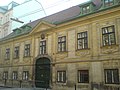
- No. 10 : Former farm yard of the Barnabitenkolleg, seat of the Swedish Church in Vienna
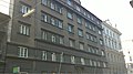
- No. 45 : Municipal housing from 1926
- No. 72: Inscribed 1637 in the courtyard of the Grenzstein house, "Luckerter Stein"
- No. 79 : Municipal housing, built 1926–1927
- opposite No. 104 (Aumannplatz): Memorial to Norbert Liebermann
- No. 100–108: St. Carolus Home of the Sisters of Mercy of St. Charles Borromeo, built in 1879/75, expanded in 1885 and 1905
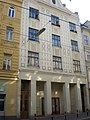
- No. 119 : Secessionist building (approx. 1910), former Währing citizen theater
- No. 140, 142 : Weinhaus parish church with both tracts of the rectory, end of the 19th century
- between No. 166 and 168 : bridge of the suburb line over Gentzgasse
Picture gallery

Wayside shrine at the corner of Semperstrasse

Former Dorotheum (No. 8)
Former Barnabite Free Farm (No. 10)
At Riglergasse, out of town
Municipal housing, No. 45

"Luckerter Stein", courtyard of no. 72

Municipal Housing, No. 79

St.-Carolus-Heim on Aumannplatz (No. 100-108)
Former Währing Citizens' Theater, No. 119

Weinhauser parish church
At Simonygasse, into town
Bridge of the suburban line

Former bridge of the suburban line (1980)


.jpg)


_-_Weinhauser_Pfarrkirche.JPG)


literature
- Bundesdenkmalamt (Ed.) Dehio manual. The art monuments of Austria. Vienna X. to XIX. and XX. to XXIII. District Verlag Anton Schroll & Co, ISBN 3-7031-0693-X (quoted as Dehio )
Web links
Individual evidence
- ↑ a b Dehio p. 490
- ↑ Mag. Johanna Scheiblhofer, Wolfgang Schranz (editor): Diverse nature in Währing. Short version. Biosphärenpark Wienerwald Management GmbH, accessed on April 12, 2020 .
- ↑ a b Gentzgasse. In: Vienna History Wiki. City of Vienna, accessed on April 12, 2020 .
- ↑ Route openings . In: Tram Journal Wiki. Retrieved April 12, 2020 .
- ↑ a b City map of Vienna. In: Website of the City of Vienna. Retrieved April 13, 2020 .
- ^ Line E2. In: Tram Journal Wiki. Retrieved April 13, 2020 .
- ↑ Dehio p. 490 ff.
- ^ Dehio p. 516
- ↑ Dehio p. 493