Schottentor
The Schottentor was one of the gates of the city wall in Vienna and was torn down around 1860 after Emperor Franz Joseph I approved the abandonment of the city wall and the construction of the Vienna Ringstrasse on December 25, 1857 . The names Schottentor and Schottengasse (so the old town alley leading to the gate) go back to the Schottenstift bordering the alley .
Today, Schottentor is understood to mean the intersection of the streets Universitätsring or Schottenring and Schottengasse or Währinger Straße with the junction with Universitätsstraße. The historical name is officially used for the underground pedestrian passage there, the two-story tram loop , the Schottentor subway station on the U2 line , which was later built on it, and the tram stops on the Ringstrasse.
history
Over the centuries, three historical buildings can be distinguished under the name Schottentor: the gate of the medieval city wall, later the gate of the renaissance wall, which was reinforced after the first Turkish siege, and finally the last city gate of this name, built around 1840.
The medieval Schottentor (13th century to 1656)
The medieval Schottentor existed for about 400 years. Up until its construction in the course of the construction of the medieval city wall in the 13th century, the walls of the Roman legionary camp Vindobona, some of which are more than 1000 years old, surrounded the city of Vienna and served to protect it.
In the 12th century, Duke Leopold V of the Babenberg family decided to build a new fortress. As a result, a building was built that was to determine the scope of the inner city for almost 700 years, the Vienna City Wall . The history of the Schottentor began with the construction of this fortification structure. It can be traced for the first time in 1276. The tower above the gate was extended in 1418 and converted into a residential building that existed until 1839. With the construction of the Schottentor, the city of Vienna now had seven city gates. The medieval city wall was a circular wall more than 4.5 kilometers long with 19 towers integrated into the wall. It should have been about six meters high and about one to two meters wide. Only the main gates, the Kärntnertor and the Rotenturmtor , were, so to speak, massive gates in their own right. All the other gates, including the Schottentor, were located in one of the towers, up to 22 meters high, which bore the same name as the gates that housed them. At the gates were the so-called Zwinger , porches with battlements . A wooden bridge led from the Schottentor over the moat in front of the walls of the city of Vienna.
The two main gates to the city were with the Kärntnertor (the actual main gate of the city) in the south and with the Rotenturmor in the northeast. Coming from the west one entered the city through the Schottentor or the Widmertor , from the southeast through the Stubentor . On the Danube (now the Danube Canal ) you could use the Rotenturmtor, the Werdertor and the Salztor to get into the city. Due to the toll, access for trucks and merchant cars was only permitted through the Rotenturm Gate, where the “Mauthäusel” was located.
The gates were only open in daylight, at dusk they were closed and the gate keys were handed over to the mayor by the gatekeepers of the city guard.
In the 15th century, a historic event took place in the immediate vicinity of the Schottentor . During the siege of the city of Vienna by the Hungarians led by their King Matthias Corvinus , Matthias' core force camped in front of the Schottentor.
These more than 700 year old names of the medieval gates and towers of the old city wall are still present to the residents or visitors of the city of Vienna. They still exist: in street names, names of subway stations and so on. “Schottentor” is also a very well-known term in Vienna today.
The older Schottentor of the Renaissance wall (1656 to 1840)
The oldest city entrance with the name Schottentor was followed by the older Schottentor of the Renaissance wall for 184 years.
After the first Turkish siege of Vienna (1529) it was recognized that the city wall from the Middle Ages no longer offered adequate security, and extensive renovations began. The old masonry was replaced by new walls ( curtains ) and the old towers by bastions . With the Schottenturm from the Middle Ages, the Schottentor was demolished and rebuilt in the course of the construction of the curtains. This older Schottentor of the Renaissance wall was completed around 1656.
In the reign of Ferdinand III. the wall was extended. Among other things, so-called ravelins were built between the bastions . In front of the Schottentor there was now the Schottenravelin for better protection, which, like the gate, was completed around 1656.
Coming from the suburb in the west, the Schottentor could be reached via a bridge spanning the moat to the Schottenravelin and from there via another bridge to the gate itself.
At that time, in front of the wall and the gates of Vienna, people saw the city moat with a width of about 20 meters and a depth of about seven to eight meters, which was probably only permanently under water near the Danube.
For reasons of military security, there was also a 300 meter wide, undeveloped area, the glacis, adjacent to the wall .
The gateways were clad with large black ashlar stones. An important facility was located under the Schottentor: a water pipe into the city to supply the people of Vienna.
The younger Schottentor of the Renaissance wall (1840 to approx. 1860)

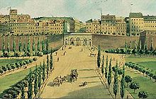
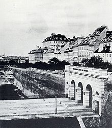
In 1840 the older Schottentor of the renaissance wall was demolished and a gate was built, which in its architectural form resembled the new outer castle gate that still exists today . It was divided into two gates for pedestrians and three relatively narrow gates for vehicles. In addition, the bridge over the moat was widened. If you entered the city through the gate, you came straight to the Schottenstift and the Freyung . “The five follies”, as the vernacular called the new Schottentor, was only 20 years old.
The Schottentor came to an end when Emperor Franz Joseph I ordered the city walls to be razed on December 25, 1857, and a boulevard, Vienna's Ringstrasse , to be built in their place . In March 1858, at the Rotenturmtor near today's Rotenturmstrasse, work began on razing the walls that had survived for centuries, protecting the city, but ultimately also narrowing it down. The Schottentor was demolished around 1860. The Ringstrasse was officially opened in 1865, but was not actually completed around the former Schottentor until 1870 and was partially built later. So was z. For example, the Palais Ephrussi at the corner of Universitätsring / Schottengasse was built in 1872/1873, and the main building of the University of Vienna on the opposite side of it was built between 1877 and 1884; the previous building on the corner of Schottengasse / Schottenring opposite to the main establishment of the Creditanstalt-Bankverein , built in 1909–1912 , a large apartment building , but existed as early as the mid-1860s.
Transport hub
The Schottentor is the starting point of the leading out of town at the corner of University University Street (the other side of the two lines in the Alserstraße passes) and one block outside the ring starting Währingerstraße . The first Viennese “horse tramway” drove from here on October 4, 1865 through Alser Strasse to Hernals . The Schottentor U2 station has been located here since 1980 . Today, ten tram lines (D, 1, 37, 38, 40, 41, 42, 43, 44, 71) and two bus lines (1A, 40A) meet here in addition to the U2 underground line . Thus, the Schottentor is one of the largest nodes in the public transport network in Vienna.
On April 29, 1961, an above-ground and on September 16, 1961 an underground loop system was opened for the tram lines, which allowed the closure of several above-ground loops (some of which were located within the ring road). Because of the oval shape, which, seen from above, together with the tram ramp to Währinger Straße, reminds of a small pot or a casserole (in Viennese: "Reindl") and in tribute to the then mayor Franz Jonas , this loop system is still used by many Viennese Jonas today . Reindl or Jonasreindl called. The trains of lines 43 and 44 coming from Universitätsstraße are routed over the above-ground loop, the loop in the first basement is used by lines 37, 38, 40, 41 and 42 coming from Währinger Straße. (Structural consideration was given to an extension of the underground tram along Herrengasse to the opera, which was no longer considered after the planning of the Vienna subway in the mid-1960s .)
Connected to the tram loops is an underground pedestrian passage, which can be reached via fixed stairs and escalators and which allows the Ringstrasse and Schottengasse to be crossed underground. In the passage or on the underground loop there are fast food outlets, various shops and a toilet facility.
When the underground line U2 was built, a connection between the new underground station and Jonas-Reindl was created in 1980; it became the main gateway to the station. In addition to the escalators, passenger elevators were also installed subsequently. In the passage to the underground there are shop windows as well as an advance booking and information point for Wiener Linien. The architect of both the passage and the connection to the subway was Kurt Schlauss .
swell
- Walter Hummelberger, Kurt Peball: The fortifications of Vienna . Paul Zsolnay Verlag, Vienna / Hamburg 1974.
- Wilhelm Kisch: The old streets and squares of Vienna and their historically interesting houses . M. Gottlieb's publishing house, Vienna 1883.
Web links
- The Schottentor crossing is being rebuilt . In: Arbeiter-Zeitung , June 30, 1959, p. 3.
Coordinates: 48 ° 12 '50 " N , 16 ° 21' 41" E


