
Vienna city walls


The Viennese city walls were structures that served to fortify the city of Vienna from the time of the Celtic and Roman camps in Vindobona . They were expanded and modernized again and again over the centuries, but were demolished in the years 1858–1864. The inner fortification ring encompassed the city center of Vienna and, in an emergency, also offered refuge for the population from the suburbs. An additional outer ring of fortifications around the suburbs was created with the line wall at the beginning of the 18th century. The Vienna city walls survived several sieges , including the first and second Turkish sieges .
history
Originated with the Roman camp Vindobona
In Vindobona one can speak less of a city wall than of a camp wall. In the early phase it occupied parts of today's 1st district of Vienna from the Danube Canal to the Hohe Markt and from today's Tiefen Graben (at that time the bed of the Ottakringer Bach ) to today's Rotenturmstrasse . In a later phase, the camp wall was extended to Naglergasse. In the past, intermediate walls separated the inhabited eastern half of the camp from the uninhabited western part. Such a wall ran in the course of today's Marc-Aurel-Straße. The Romans dug a trench in front of this wall, which, although no longer visible, still bears this name today. The Vindobona camp had only three gates, porta principalis dextra (right gate) to the northwest, porta principalis sinistra (left gate) to the southeast, the Limesstrasse (between Asturis ( Klosterneuburg ) and Ala Nova ( Schwechat )) ran over the Via Principalis porta decumana (back gate, south gate) to the southwest. The northeast wall had no main gate ( porta praetoria ) and ran along a slope to the Danube.
The bricks and stones were brought in from clay pits or quarries in the area. Possible clay pits were in the 17th district of Vienna, at Schottentor and Gumpendorf . The quarries for this were probably in Sievering and from the Leithagebirge ( Mannersdorf , Kaisersteinbruch ). The exact origin of the bricks and stones is not documented until the late Middle Ages .
City wall until the 12th century
The Babenbergers adapted the Roman camp wall and expanded it into a medieval city wall. The porta principalis dextra became the Ungartor, a merchant town formed in front of it, the porta decumana became the Peilertor, then called Paevrertor or Baylertor. They reused the existing stones from the former Roman camp and added new stones from Heiligenkreuz, Wildegg, along the Danube from Greifenstein to Kahlenbergerdorf and Leithagebirge . Marbles were shipped from Tyrol over the Inn and Danube to Vienna. The amount of stones from Roman times was so large that they were also used for parts of St. Stephen's Cathedral in Vienna .
City walls from the 13th century to the first Turkish siege


With the ransom money from the capture of Richard the Lionheart in 1192, Leopold V financed the filling of the (still so-called today) trench from St. Stephen's Cathedral to Freyung and built city walls in the dimensions that were to exist until the 19th century. Individual remains of the older city fortifications, such as the Peilertor between Kohlmarkt and Tuchlauben , have been preserved. Little changed in the city walls over the next few centuries. The Viennese did not feel threatened and therefore no one saw the need to bring the city wall up to date with the latest military technology.
Several gates were built in the Middle Ages. The Kärntnertor, Widmertor and Schottentor are mentioned by the end of the 13th century at the latest . The Werdertor was built in 1302, the Stubentor and the Rotenturmtor in 1314 .
But already in 1529 the Turks under Sultan Suleiman I advanced as far as Vienna and besieged the city for a month. They attacked the city at the Kärntnertor. The Turks could not fire heavy cannons because the rainy summer had softened the supply routes and only cannons of small caliber could be brought in front of the city walls. The medieval city wall would have been easy to destroy with the large cannons, which they had to leave far behind Vienna due to the weather. So the Turks tried to break the walls through mines. Mine warfare began. Using water-filled bowls or buckets and drums, with peas being placed on the stretched calfskin, the Viennese were able to roughly localize the excavation work and take countermeasures. After a month of siege, the Turks managed to break out several breaches, the last one of 30 meters in masonry (Suleiman breach). But as the walls fell outwards, the attacking Turks had to fight their way slowly over the rubble and were repulsed by pikemen and arquebusers . In addition, this gave the Viennese enough time to build palisades and dig trenches and thus prevent the city from being stormed.
City walls between the Turkish sieges

with a cat (cavalier), ravelin, bastion
in the background Covered path with arms place and palisades in front of the glacis

From this point on, plans were made to convert the city walls into a modern fortress based on the Italian model. In 1547, the Mayor of Vienna Sebastian Schrantz commissioned Augustin Hirschvogel from Nuremberg with the first planning proposals. Another plan was drawn up by his stonemason Bonifaz Wolmuet . In 1548 Italian fortress builders were brought in from Lombardy, especially from the area around Como and Lugano. The fortress architect Domenico dell'Allio should be mentioned as one of the most important artistic personalities . The medieval wall towers were converted into ten bastions . The beaver, Schotten and Krot tower were only under Charles VI. and the Fach- und Judenturm was only razed under Josef II. The city walls were built a little lower, but wider and in front of it a trench was dug with a countercarp . A covered path was then laid with an earth wall as protection in front of it and attention was paid to the free protective distance of 300 meters in the glacis to the first houses after the city. The part of the city wall that bordered the Danube Canal was only converted into a modern fortress in the 17th century.
In Vienna the term bastion was always used for bastions . This designation was used in all drawings and descriptions below, including those by Daniel Suttinger , the Austrian fortress construction engineer. It is an Austrianism here .
The ditch was filled with water in the northeast by the Alserbach and in the south by the Wien River. Only on the north-western and western side between the Augustinian Bastion and the Schottenbastei did the moat remain dry.
After the Thirty Years War began under the emperors Ferdinand III. and Leopold I. a large-scale expansion of the fortification facilities. During the reign of Ferdinand III alone. (until 1657) the stately sum of over 80,000 florins was paid out from the court chamber . The old Italian manner was expanded to a new Italian one, with independent fortifications, so-called ravelins , also called Schanzl by the Viennese, added between the bastions . Behind the bastions, elevated artillery positions were created, the so-called cavaliers , also known as cats. The front walled edge of the ditch, the countercarp , was six meters deep and zigzagged; then a covered path , which was demarcated by palisades from the open apron, the glacis .
An attacker could not take the fortress by storm, but had to work his way through the glacis to the palisades and the covered path with trenches. These had to be undermined, blown up and thrown into the ditch together with the counter-rake. Next, the attacker had to dig his way down tunnels into and through the trench, where he was under fire from the coppice, caponiers, ravelin, and bastions. Finally the bastions, the ravelins and the city wall had to be undermined, blown up and then taken by storm.

This construction work was finished in 1672 - just in time, because 10 years later, in 1683, the Turks besieged Vienna again. A year earlier, the peace negotiations between the Ottoman Empire and Emperor Leopold I failed, the fortress engineer Georg Rimpler from the Saxon town of Leisnig, who made a name for himself in the St. Andrea bastion during the siege of Candia on Crete (1669) had made, commissioned with the expansion and improvement of the fortress Vienna. Emperor Leopold paid him 2000 guilders and put him in service as a lieutenant colonel. Under the city commandant, Count Ernst Rüdiger von Starhemberg, he reinforced the city wall, the countercarp and the covered path, built caponiers and the low wall on the bastion flanks and set up barriers on the individual fortress parts, which prevented the conquest of the entire complex when part of the complex was conquered . Georg Rimpler correctly recognized that the main attack by the Turks would be between Löwelbastei and Burgbastei.
The castle bastion (the left wing of the defenders , the right wing of the attackers ) was a regular square with nine cannons each , but it had no mine system. Behind the castle bastion was the cavalier, the Spaniard bastion, a raised artillery fortress. The Löwelbastei (the right wing of the defenders, the left wing of the attackers) was smaller than the castle bastion and behind it the cavalier, called the "cat" , took up space again.
Criticism: The more than 200 meter long city wall between the bastions was too long for an effective use of grapefruit . In addition, the Ravelin was pushed a little too far into the trench and built a little too high, so that artillery fire in the trench behind the Ravelin from the bastions was only possible to a limited extent.

In the mine war for Vienna, the Ottomans had a clear advantage with 5,000 miners . They not only had more material and personnel, but also more experience in mine warfare. Georg Rimpler hired miners from Tyrol , the Netherlands and Lorraine for this difficult service, and women were also used initially. Georg Rimpler had little fun with women. In his opinion, they kept the men in the dark tunnels from working.
City walls after the second Turkish siege
The shot ravelin and the damaged bastions were rebuilt, the trench and the countercarp repaired. Mine tunnels, which reached up to 100 m into the glacis, were driven forward and mine chambers were created at lateral distances with connecting passages to them. The remaining ravelins around the city were completed, so that the fortress Vienna became a ring of bastions and ravelins. Only on the side of the Danube Canal no ravelins were built.
At the beginning of the 18th century during the Hungarian uprising of Kuruc sat Prince Eugene for the construction of another line of fortifications, the Linienwall one. The line wall was roughly where the belt runs today and, with the exception of two episodes in 1704 and the revolution of 1848, had no military significance. Its importance lay rather in its function as a customs border for the consumption tax , which economically carried out the urban expansion around the suburbs. He was to hold this position until 1892. It has served as the city boundary for the past four decades.
Conversion to the recreation area

For a long time, the glacis was a “dusty desert”, but after losing its military importance as a free field of fire in 1770, on the orders of Emperor Joseph II, the construction of a road and access roads to the individual city gates was structured, the space in between “with clover seeds and other grass - Species sown and trimmed ”. In 1781 the emperor ordered the construction of avenues (according to the cost estimate, over 2000 trees were planted). From 1776, the glacis was illuminated by lanterns, not least for police reasons. According to Elisabeth Lichtenberger, a special wave of beautification began after the wall ring was pushed in, including the Volksgarten. Similar to other ramparts that are becoming obsolete , such as those in Hamburg , the fortification zone around the core city thus primarily became a popular and picturesque local recreation area for a few decades, which numerous reports from contemporary observers confirm. During his visit to Vienna in July 1811, Joseph von Eichendorff noted in his diary the “wonderful views of the Stephansturm and the suburbs and their palaces” from the glacis, and Frances Trollope called the bastions “the most splendid” in her book Vienna and the Austrians , published in 1838 City promenade of the world ”. The water glacis located in the area of today's city park was particularly popular . Parts of the city fortifications around the so-called Elendsbastei near the Schottentor were also long in disrepute as a place of prostitution and petty crime.
demolition


At the beginning of the 19th century, Napoleon occupied Vienna in 1805 and 1809. Since the fortifications had no military significance, Vienna was surrendered in 1805 without a fight. In 1809 it took brief but effective bombardment and the city was opened to the French. Now Napoleon had the city wall between Löwelbastei and Augustinerbastei razed. This actually began the demolition of Vienna's city fortifications. However, the Viennese initially rebuilt the city wall as a Hornwerkskurtine (1817–1821), relocating the walls somewhat outwards and integrating today's Volksgarten into the city. The castle gate , which is still visible today, was built about 50 meters in front of the old castle bastion and integrated into the wall ring. At the same time, however, the ravelins were eliminated. Militarily, they made little sense and only took up space. In 1848, the rebellious students and citizens joined the revolution in the city, and for the first time the military realized that the Vienna city walls were no longer a protection for the authorities, but rather a threat. Two large barracks were therefore erected in the area of the city fortifications, today's Rossauer barracks and the later demolished Franz Joseph barracks in the area of today's Stubenring. Economic reasons (the use of the potentially high-priced glacis grounds near the center) also spoke in favor of softening. In fact, the city expansion fund should not only succeed in fully financing the state-of-the-art public buildings on the Ringstrasse through the sale of plots to private individuals, but even generate a surplus. The city gates also acted as traffic obstacles.
The demolition of the fortifications, announced at the end of 1857 by the “highest hand ticket”, began in March 1858 at the Rotenturm Gate. "Franz Josephs Quai" was opened on May 1st, 1858. Next came the southeastern part of the fortifications. Individual buildings, such as the Palais Coburg and the Palais Archduke Albrecht with its collection ( Albertina ), have been preserved at the height of the old city wall. This made the construction of ramps necessary. The last thing that was demolished from 1861 to 1863 was the wall belt between Schottentor and Augustinerbastei. The Vienna Ringstrasse was opened on May 1, 1865 (albeit without the splendid buildings built later). The era of the Vienna city wall had come to an end.
No remains of the city fortifications have survived above ground. During the construction of the Stubentor underground station , parts of the masonry were exposed from 1985; they are now visible both next to and in the station. Construction work also unearthed the walls of the former beaver bastion. After the fortifications were demolished , brick walls were built in front of the Mölker Bastei , along Hanuschgasse and in front of the Coburg Bastion in order to secure the embankment. These are sometimes mistaken for remnants of Vienna's city walls. The outer castle gate is the only gate that has been preserved, but in a modified form. Street, alley and square names, even shops, are still reminiscent of the walls and gates, such as the Schottentor and Stubentor subway stations , the Stubenbastei, Dominikanerbastei , Coburgbastei, Mölker Bastei, Schottenbastei and Rotenturmstrasse as well as Werdertorgasse.
Material science
Quarries
- Leithagebirge : Delivered limestone and sand-lime bricks from several quarries. Mannersdorf, Kaisersteinbruch (from the middle of the 16th century), Breitenbrunn and Au are mentioned by name.
- Weidlingau : Is mentioned from the 15th century and becomes more important in the 18th century.
- Hütteldorf : Delivered paving stones and rubble stones.
- Dornbach : Delivered a particularly large number of stones at the time of the threat from the Turks in the 16th and 17th centuries.
- Sievering : Certainly existed from the 14th century, but probably goes back to Roman times. The City of Vienna acquired this facility in the 15th century and developed it into a large facility. Here mainly stones were broken for paving the street.
- Grinzing : Documented mention in 1417 for the construction of a chapel.
The actual use of the stones from these places was probably much older.
Transportation of the stones
The location of Vienna on the Danube was very convenient for the transport. Whenever possible, the Danube was used as a transport route. The transport costs for Mannersdorfer stones from the Leithagebirge three times as much as the stone itself.
lime
Lime was required for processing stone to wall. In order to produce this, it had to be burned and extinguished on site. The quicklime was obtained almost exclusively from the limestone foothills south of Vienna by professional lime burners. The sources almost exclusively name Rodaun, sometimes also Kalksburg, Brühl, Perchtoldsdorf, Baden and Vöslau. There was no fire in Rodaun itself, only the "wholesale point" was here. The individual quarries and ovens were deeper in the foothills of the Alps. Around 1500, the City of Vienna temporarily operated a limestone quarry and 2 ovens near Nussberg on its own and used the Leitha limestone that existed there. The great waste of wood led to a decree under Rudolf II in 1581 that wood could only be felled with permission.
brick
Brick was the cheapest and most natural of all building materials. Particularly high-quality clays from tortone, Sarmatian and Pannone stages, also loam and loam from the ice age deposits and finally the “silt” (fine sand to flood loam) of the Danube valley. There were brick pits in front of the Schottentor, Hessgasse, Liechtensteinstrasse and Gumpendorf. Masonry bricks and roof tiles were burned from this in brickworks. These were located on the grounds of today's State Opera and on the Vienna River . Documented, the distinction between brick and stone is not always possible because bricks were called stones.
Names of the bastions and city gates

Following a pictorial representation by Carl Wenzel Zajicek (after Emil Hütter ), immediately before the city wall was torn down, the following bastions and city gates (viewed counter-clockwise, starting at the eastern corner of the city fortifications on the bank of the Danube Canal):
In the course of time, the bastions had different names. For the first one, built in 1544 at the Dominican Church and named after it today, the names Prediger- or Hollerstaudenbastion were used, or because of their funding by the city, the name Bürgerbastion. On this Dominican bastion (today's name of the street that runs there) there was also a cavalier as reinforcement . A curtain wall - broken by Stubentor - led then to the so-called Braunbastei (formerly also from the nearby St. James Monastery Jakober bastion in the 16th century also called Lower Paradeisbastion.). Before that, the so-called Stubenschanzl was built around 1660 as a free-standing ravelin (then demolished in 1821). The current street name Stubenbastei only appeared from 1795 as a designation for the row of houses within the wall, and after the demolition in 1862 also for the street that was created there, which today marks the border of the old town to the grid construction of the ring road zone.
After another curtain wall (with an upstream Ravelin called Dachsloch), the Wasserkunstbastei followed as the southeast corner of the city fortifications . Named because of its pumping station, housed in a wooden tower, which from the 16th century carried water into the city from an arm of the Vienna River. For a long time, the curtain wall of the Kärntnertor bastion caused structural problems (because of the Vienna River) . This important cornerstone of the fortification, financed by the imperial estates, including the cavalier, was not completed until 1552. It also replaced the old Kärntnertorturm, which was particularly badly damaged during the Turkish siege. The New Carinthian Gate (a continuation of today's street) was built in the curtain wall and connected to the Carinthian Ravelin via a bridge.
The approximately 250 meters to the castle bastion were a temporary solution for a long time. The curtain wall, which was built as an embankment, often slipped. Only in 1596, when the Turkish threat broke out again, was there any further expansion here. A 340 meter long curtain wall (in front of it - for example on the site of today's Burgtheater - was the Schanz in front of the castle gate ). Then came the Löwelbastei , built in 1544 (originally as the Roman Royal Majesty Bastion - then also called the Landscape Bastion because of its proximity to the Lower Austrian country house). In 1649 it got its current name - which is a corruption of Löblbastei - named after a town guardian.
The curtain wall to the Mölkerbastei (name of the nearby Melkerstiftshof - it was also called Schottenbastion - also after the neighboring monastery) was built as early as 1596 , and was also towered over by a cavalier. It reached about as far as the main ramp of today's university on the Ring - the remains of the wall that still exist today come from the curtain wall. The Schottentor , which until then had been in the Schottenturm, was protected in the following curtain wall and with a wooden bridge over the upstream Schottenravelin, only built until 1656. The following section was also only bricked between 1630 and 1656.
From a structural point of view, the direction of the Danube was then in a section that was difficult to build on. The construction of the misery or corner bastion (end of construction in 1561 financed by means of the imperial estates) was made more difficult by the sloping, damp terrain. The old Jewish tower that had previously stood there was also used as a powder tower because the arsenal had been moved there. The Neutor , which replaced the medieval Werdertor in 1558 , led through the curtain wall to the Neutorbastei . Here, too, it was protected by an upstream ravelin of the same name. The Danube front of the city stretched from the Neutorbastion to the Beaver Bastion. The raised bank was built on with the Ravelin Wasserschanzl , where the Fischertor on the left flank also led out of the Great Gonzagabastei (formerly also Donaubastei); afterwards the water gate (around today's Schwedenplatz) and the small Gonzagabastei (from around 1795 also called Rotenturm bastion - demolished in 1858/59) were in the curtain wall. The New Rotenturmtor and the Laurenzertor followed at the striking bridge to Leopoldstadt . The corner was formed by the beaver bastion , which was only completed in 1563 (demolished in 1863/64). The beaver tower (Pyberturm) had already been expanded there in 1529. In 1602 it was reinforced by the upstream Judenschanzl (with the toll gate ) and in 1650 the Biberschanzl (demolished in 1818).

Prominent buildings
It was not until the end of the era of the bastions that prominent buildings emerged on them, such as the Palais Lubomirski built in 1812 and the Palais Coburg built in 1843–47 . The Archduke Albrecht Palace , the first noble residence built on the bastion, served as a model . The mighty Franz-Joseph-Kaserne (built 1849–57, demolished in 1900) and the associated Franz-Josephs-Tor (from 1850–54) came from the period just before the decision to demolish the city fortifications. A special case is the house "zum golden Kegel" (often called "Kegelhaus" or "Großer Kegel"), which is very conspicuous in old views. The seven-story building with a high roof was de facto the first high-rise in the center of Vienna. But it stood on the badly reputed misery bastion and is probably largely forgotten because of this social downgrading of the whole area around the Schottensteig.
Vienna city walls over time

Vienna after the reconstruction of the medieval city wall, 1548

Bird's eye view of Vienna from the north, 1609

Residence city Vienna
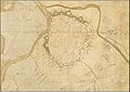
Vienna 1704

Vienna 1783

Vienna around 1800

Vienna 1835

Vienna around 1850

Vienna 1858


See also
literature
- Felix Czeike : Vienna. Art, culture and history of the Danube metropolis. 5th updated edition. DuMont-Reiseverlag, Ostfildern 2008, ISBN 978-3-7701-4348-1 , p. 60.
- Bernd Fahrngruber: Construction-related aspects of the Vienna city expansion under Emperor Franz Joseph I. The razing of the Vienna city wall from 1858 to 1864. Dissertation, Vienna University of Economics and Business, Vienna 2001, wu.ac.at (PDF).
- Walter Hummelberger , Kurt Peball : The fortifications of Vienna (= Viennese history books . Volume 14). Zsolnay, Vienna a. a. 1974, ISBN 3-552-02606-1 .
- Walter F. Kalina: The Vienna fortress construction at the time of Emperor Ferdinand III. and Leopold I. (1637–1672). In: Austrian magazine for art and monument preservation. Vol. 60, No. 3/4, 2006, ISSN 0029-9626 , pp. 380-384.
- Claudia Reichl-Ham: "To hold the fortress or to fall with it." The castle bastion and its military-historical significance. In: Viribus Unitis. Annual report 2010 of the Army History Museum. 2011, ZDB -ID 2114718-8 , pp. 48–91 ( online in the HGM Wissens-Blog ).
- Helfried Seemann (Ed.): Vienna - Inner City, 1850–1860. City walls, gates, bastions, panoramic view from St. Stephen's Cathedral 1860. Album, Vienna 1995, ISBN 3-85164-039-X .
- Vienna city and castle fortifications (= Austrian Journal for Art and Monument Preservation, Vol. 64, Issue 1/2, 2010, ISSN 0029-9626 ).
- Carl Wenzel Zajicek , copied from Hütter : Die Basteien Wien. (View of the imperial and royal imperial = capital and residence city of Vienna in N. Austria. Before the city expansion and demolition of the city began, walls and gates in 1858). Commented by Walter Öhlinger. Archiv-Verlag, Vienna 2005.
- Heike Krause, Gerhard Reichhalter, Ingeborg Gaisbauer, Ingrid Mader, Sylvia Sakl-Oberthaler, Christine Ranseder: Walls around Vienna. The city fortifications from 1529 to 1857 (Vienna Archaeological 6) 2nd, revised and expanded edition. Vienna 2014, ISBN 978-3-85161-074-1 .
- Ferdinand Opll, Heike Krause, Christoph Sonnlechner: Vienna as a fortress city in the 16th century. On the cartographic work of the Angielini family from Milan . Vienna 2017, oapen.org
- The expansion of the city of Vienna . In: Wiener Zeitung , December 25, 1857, pp. 1–2 ( Wikisource )
Web links
- Heimatkunde Vienna - Information on the bastions ( Memento from October 22, 2007 in the Internet Archive )
Individual evidence
- ↑ see historical Vienna map
- ↑ The Roman Age in Vienna - Vindobona Legionary Camp
- ↑ a b c Building history of the medieval city walls of Vienna ( Memento from May 2, 2011 in the Internet Archive ), A. Kieslinger A, source: Restauratorenblätter, 1979
- ↑ Gerhard Eichinger: Heinrich II. Jasomirgott
- ^ Artaria & Compe: Ground plan of Vienna, copper engraving, 1812 , with an additional map on the situation in 1157
- ↑ Map and explanation by Augustin Hirschvogel ( Memento from August 14, 2010 in the Internet Archive )
- ↑ map and explanation Bonifaz Wolmuet ( Memento of 9 June 2011 at the Internet Archive )
- ^ Vienna's sieges by the Turks and their incursions into Hungary and Austria , Google Books p. 109
- ^ Walter F. Kalina: The Viennese fortress construction at the time of Emperor Ferdinand III. and Leopold I. (1637–1672) . In: Österreichische Zeitschrift für Kunst und Denkmalpflege , Vol. 60, No. 3/4, Vienna 2006, pp. 380–384, ISSN 0029-9626
- ↑ Klaus-Peter Matschke: The cross and the half moon. The history of the Turkish wars . P. 358 f. (Secondary literature)
- ^ A b Walter Sturminger: The Turks before Vienna . Karl Rauch Verlag, Düsseldorf 1968, p. 32 (secondary source) quoted Lieutenant Colonel Johann Georg von Hoffmann from the annual report of the Realgymnasium of the Theresian Academy in Vienna 1937 by Dr. Stefan Hofer, pp. 3–17.
- ↑ Georg Rimpler's life story ( Memento from January 11, 2012 in the Internet Archive ) (PDF; 849 kB)
- ↑ Leander Anguissola, Johann Jacob Marinon: Floor plan of Vienna with its suburbs and the line wall 1704 (1706) ( Memento from February 27, 2014 in the Internet Archive )
- ^ The expansion of the city of Vienna . In: Wiener Zeitung , December 25, 1857, pp. 1–2 ( Wikisource )
- ↑ Remains of the beaver bastion discovered during construction work
- ↑ A. Kieslinger: Origin and use of burnt lime for medieval buildings in Vienna . ( Memento of May 2, 2011 in the Internet Archive ) In: Restauratoren Blätter , 1979
- ↑ Brick pits in the city of Vienna in the late Middle Ages ( Memento of May 2, 2011 in the Internet Archive ), A. Kieslinger A, source: Restauratorenblätter, 1979
- ↑ See Hummelberger, Preball p. 33 ff. - with a plan in the appendix.