Mannersdorf am Leithagebirge
|
Borough Mannersdorf am Leithagebirge
|
||
|---|---|---|
| coat of arms | Austria map | |
|
|
||
| Basic data | ||
| Country: | Austria | |
| State : | Lower Austria | |
| Political District : | Bruck an der Leitha | |
| License plate : | BL | |
| Surface: | 29.92 km² | |
| Coordinates : | 47 ° 58 ' N , 16 ° 36' E | |
| Height : | 212 m above sea level A. | |
| Residents : | 4,138 (January 1, 2020) | |
| Population density : | 138 inhabitants per km² | |
| Postal code : | 2452 | |
| Area code : | 02168 | |
| Community code : | 3 07 16 | |
| NUTS region | AT127 | |
| UN / LOCODE | AT TIME | |
| Address of the municipal administration: |
Hauptstrasse 48 2452 Mannersdorf am Leithagebirge |
|
| Website: | ||
| politics | ||
| Mayor : | Gerhard David ( SPÖ ) | |
|
Municipal Council : ( 2020 ) (23 members) |
||
| Location of Mannersdorf am Leithagebirge in the district of Bruck an der Leitha | ||
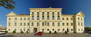
 The city administration is housed in the former Mannersdorf Castle on the Leithagebirge |
||
| Source: Municipal data from Statistics Austria | ||

Mannersdorf am Leithagebirge is a municipality with 4138 inhabitants (as of January 1, 2020) in the district of Bruck an der Leitha in Lower Austria .
geography
The town of Mannersdorf am Leithagebirge is located in the industrial quarter at the foot of the Leithagebirge in the southeastern part of Lower Austria. The area of the municipality covers 29.8 square kilometers. 42.15 percent of the area is forested.
Community structure
|
structure
|
The municipality includes the following three localities (residents in brackets, as of January 1, 2020):
- Mannersdorf am Leithagebirge (3411)
- Sandberg (78)
- Wasenbruck (649)
Mannersdorf only consists of a single cadastral municipality, but there is another place about four kilometers northeast of Mannersdorf, Wasenbruck with around 400 inhabitants. This village, which is mainly inhabited by commuters, lies between the Leitha and the factory canal branched off from the Leitha for the now closed carpet and felt cloth factory in Wasenbruck.
About 6 kilometers to the north is the district of Sandberg, which is separated from Götzendorf by the Leitha .
history
Around 1980, over 90 graves from the Latène period were excavated and scientifically examined in the corridor "Reinthal Süd" . The grave goods consisted partly of silver, gold and coral, a bronze situla is seen as an imported piece from northern Italy. The finds document trade relations that stretched from the central Rhine and Champagne to south-eastern Europe and northern Italy .
In ancient times the area was part of the province of Pannonia . The Huns skulls of Mannersdorf will be considered evidence for the presence of Huns in the 5th century. The place was first mentioned in a document in 1233. In 1786, the well-known bath in Mannersdorf, which had existed until then, was dissolved by a decree by Emperor Joseph II . The bath was very popular in the middle of the 18th century and was even visited by Empress Maria Theresa . In 1750, Joseph Haydn probably met the already established composer Christoph Willibald Gluck in Mannersdorf , who is said to have encouraged his young colleague in his musical mission.
The area of the St. Anna monastery in the desert is located in the municipality and has been a nature park since 1986. The 106-hectare monastery area is surrounded by a 4.5 km long wall, some of which can still be seen. The Discalced Carmelite Monastery, which was abandoned by Emperor Joseph II in 1783 , was founded by Eleonora of Mantua in 1644 , burned down by the Turks in 1683 and later rebuilt. The meanwhile restored church and an outbuilding have been preserved. The monk cells have fallen into disrepair. Based on an engraving by LM Lerch from 1689, the structures of the monastery are clearly visible. In the center of the complex, which is located in a wide clearing and can be reached via an avenue of lime trees, is the monastery church. Twenty monk cells are grouped on three sides. These each consisted of a room with a garden and a window to the outside. The common rooms are on the fourth side. Attached to the monastery were seven hermitages , a farm, orchards, a fish pond, as well as three quarries and lime kilns . The cloister gate with a mighty archway, the Leopold's chapel and the porter's house are also clearly recognizable.
The history of the last centuries is still closely linked to the lime mining in the Leithagebirge, so the lime was burned in the 19th century and in the first half of the 20th century. The stone was also often used in Vienna for the construction of the Ringstrasse . In 1894 the Mannersdorfer cement factory, which still exists today, was founded, in which the lime has been processed into cement until now.
Mannersdorf was promoted to town in 1990.
Population development

Culture and sights
- Catholic parish church Mannersdorf am Leithagebirge hl. Martin, with cemetery and rectory
- Mannersdorf Castle am Leithagebirge with the main use as a municipal office
- Schüttkasten Mannersdorf am Leithagebirge with the use as a museum Mannersdorf and the surrounding area
- Maria Theresa Obelisk
- Former court stockl
- Perlmooser Hof with chapel
- Former town hall and rectory: today a residential building
- Schwabenhof: extensive medieval buildings
- Perlmoos cement works with a factory museum set up in 1986 and a Mannersdorf factory settlement built in 1953 , planned by architect Roland Rainer
- Baxa lime kiln with lime kiln and stone mining museum
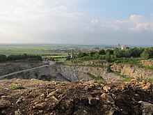
- Quarries, dismantled as early as Roman times, conveyor belt bridge from 1917, crusher building from 1929, staff house from 1939
- Mannersdorf Desert Nature Park , including:
Economy and Infrastructure
In 2001 there were 133 non-agricultural workplaces and 47 agricultural and forestry holdings according to the 1999 survey. According to the 2001 census, the number of people in employment in the place of residence was 1647. In 2001, the employment rate was 45.18 percent.
There is a Lafarge Perlmooser cement plant in Mannersdorf . It is the largest cement plant in Austria with a production capacity of 1.1 million tons. This plant also includes the highest structure in the village, a 118 meter high chimney, which also serves as a radio relay base.
politics
Municipal council
| Results 2015 | Results 2010 | Differences | |||||||
|---|---|---|---|---|---|---|---|---|---|
| be right | % | Mand. | be right | % | Mand. | be right | % | Mand. | |
| Eligible voters | 3632 | 3406 | + 226 | ||||||
| Votes cast | 2274 | 62.61% | 2352 | 69.05% | - 78 | - 6.44% | |||
| invalid votes | 45 | 1.98% | 40 | 1.70% | + 5 | ||||
| valid votes | 2229 | 98.02% | 2312 | 98.29% | - 83 | - 0.28% | |||
| Political party | |||||||||
| SPÖ | 1079 | 48.41% | 11 | 1190 | 51.47% | 13 | - 111 | - 3.06% | - 2nd |
| LIM (List Mannersdorf) | 818 | 36.70% | 9 | 729 | 31.53% | 7th | + 89 | + 5.17% | + 2 |
| ÖVP | 202 | 9.06% | 2 | 240 | 10.38% | 2 | - 38 | - 1.32% | ± 0 |
| FPÖ | 130 | 5.83% | 1 | 153 | 6.62% | 1 | - 23 | - 0.79% | ± 0 |
| total | 100.0% | 23 | 25,796 | 100.0% | 23 | ± 0 | ± 0 | ||
mayor
- 1916–1918 Franz Parrer (CSP)
- 1916 - 1918 Franz Parrer
- 1919 - 1921 Alexander Seracsin
- 1921 - 1922 Franz Zerzawy
- 1922 - 1934 Josef Haidn
- 1934-1938, 1945-1947 Karl Gottschy
- 1938 - 1945 Victor Rapp
- 1943-1944 Hugo Sekyra
- 1947 - 1950 Johann Karpf
- 1950 - 1960 Wilhelm Pretsch
- 1960 - 1969 Josef Stahl
- 1969 - 1975 Johann Ponath
- 1975 - 1995 Johann Strobl
- 1995 - 2004 Josef Richter
- since 2004 Gerhard David (SPÖ)
City arms
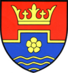
The coat of arms shows a leaf cone and a heraldic rose in a divided shield . The crown of leaves refers to the sovereign rule and the frequent presence of Empress Maria Theresa . In the middle, the shield is divided by a counter-step ledge, which corresponds to the cartographic representation of a quarry, which are of great economic importance for the community. The rose symbolizes the desert nature park on the one hand and serves as a reminiscence of the old market seal that contained a flower on the other. The three wave bars refer to the Mannersdorfer thermal spring. The colors red, yellow and blue contain the colors of Burgenland (red and yellow) and Lower Austria (yellow and blue), which expresses Mannersdorf's location on the state border.
Heraldically the coat of arms is described as follows:
In a shield divided by a gold counter-step bar above a golden crown of leaves in red, below in blue over three golden wavy bars in the base of the shield a golden heraldic rose.
Personalities
- Edmund Adler (1876–1965), artist
- Michael Gampe (* 1950), actor and theater director
- Johann Horvath (1900–1983), politician
- Friedrich Sacrifice Cow (1923–1993), master stonemason and sculptor, author
- Karl Schmoll von Eisenwerth (1852–1936), industrialist
- Heribert Schutzbier , director of the Mannersdorfer Museum, author
- Hugo Michael Sekyra (1941–1998), manager
- Karl Martin Sukopp (* 1928), sculptor
- Karl Tschank , head of the “BAXA Kalkofen” project, research: Mannersdorfer Stein for St. Stephen's Cathedral.
Web links
- 30716 - Mannersdorf am Leithagebirge. Community data, Statistics Austria .
- Entry for Mannersdorf am Leithagebirge in the database of the state's memory for the history of the state of Lower Austria ( Museum Niederösterreich )
- Mannersdorf am Leithagebirge. In: Lower Austria 3D. Retrieved on November 4, 2017 (3D representation of selected buildings and monuments).
- Videos from or about Mannersdorf in the online archive of the Austrian Media Library (stone masonry, ...)
- August Hanisch, Heinrich Schmid: Austria's quarries. Directory of the quarries that deliver cuboids, steps, paving stones, grindstones and millstones or roof slabs. Graeser, Vienna 1901. (Online at ALO ).
Individual evidence
- ↑ Statistics Austria: Population on January 1st, 2020 by locality (area status on January 1st, 2020) , ( CSV )
- ↑ Peter C. Ramsl: The Laténe Age burial ground of Mannersdorf in the Leithagebirge, Flur Reinthal Süd, Lower Austria. Austrian Academy of Sciences - OeAW. Announcements of the Prehistoric Commission Volume 74. Verlag der ÖAW. Vienna 2011. ISBN 978-3-7001-6720-4 .
- ^ Website of the community: HISTORICAL - Joseph Haydn
- ↑ Statistics Austria: dissolutions or associations of municipalities from 1945
- ↑ St. Anna Abbey ( page no longer available , search in web archives ) Info: The link was automatically marked as defective. Please check the link according to the instructions and then remove this notice. , Mannersdorf community; commons: Category: St. Anna monastery in the desert
- ↑ Municipal council election 2015 on noe.gv.at


