Trautmannsdorf on the Leitha
|
market community Trautmannsdorf on the Leitha
|
||
|---|---|---|
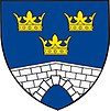
| coat of arms | Austria map | |
|
|
||
| Basic data | ||
| Country: | Austria | |
| State : | Lower Austria | |
| Political District : | Bruck an der Leitha | |
| License plate : | BL | |
| Surface: | 35.43 km² | |
| Coordinates : | 48 ° 1 ' N , 16 ° 38' E | |
| Height : | 168 m above sea level A. | |
| Residents : | 2,984 (January 1, 2020) | |
| Population density : | 84 inhabitants per km² | |
| Postal code : | 2454 | |
| Area code : | 02169 | |
| Community code : | 3 07 26 | |
| NUTS region | AT127 | |
| Address of the municipal administration: |
Kupfergasse 1 2454 Trautmannsdorf an der Leitha |
|
| Website: | ||
| politics | ||
| Mayor : | Johann Laa ( ÖVP ) | |
|
Municipal Council : ( 2020 ) (21 members) |
||
| Location of Trautmannsdorf an der Leitha in the district of Bruck an der Leitha | ||
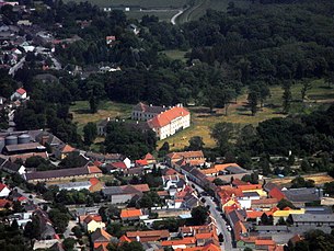
 Trautmannsdorf from the air; in the middle the lock |
||
| Source: Municipal data from Statistics Austria | ||
Trautmannsdorf an der Leitha is a market town with 2984 inhabitants (as of January 1, 2020) in the district of Bruck an der Leitha in Lower Austria .
geography
Geographical location
Trautmannsdorf an der Leitha is located in the industrial district in Lower Austria.
In the southern part of the village, parallel to the main road, the municipality is crossed by the Leitha . The area of the market municipality covers 35.39 square kilometers and is therefore the fifth largest municipality in the district (after Himberg , Schwechat , Prellenkirchen and Sommerein ). 9.56 percent of the area is forested.
Neighboring communities
| Enzersdorf an der Fischa | Göttlesbrunn-Arbesthal | |
| Götzendorf an der Leitha |

|
Bruck an der Leitha |
| Summer | ( Bruckneudorf , district Neusiedl aS , Bgld. ) ∗ |
- ∗ Bruckneudorf does not border by approx. 100 m, as Sommerein and Bruck meet there.
Community structure
The municipal area comprises four localities , cadastral communities and census districts (population in brackets as of January 1, 2020):
- Gallbrunn (725)
- Sarasdorf (673)
- Stixneusiedl (584)
- Trautmannsdorf an der Leitha (main town, KG Trautmannsdorf , 1002)
history
During the first Turkish siege of Vienna in 1529, the Turks ( Ottomans ) stood in front of Trautmannsdorf and besieged the fortress. In 1683 it was besieged again, but could be held.
In 1972 the places Gallbrunn and Stixneusiedl were incorporated (according to the Lower Austrian Municipal Structural Improvement Act of December 19, 1970), so the market town of Trautmannsdorf, together with Sarasdorf, which was incorporated in 1968, now comprises four cadastral communities.
KG Stixneusiedl celebrated its 700th anniversary in 2014.
Population development
According to the results of the 2001 census, there were 2686 inhabitants. In 1991 the market town had 2529 inhabitants, in 1981 2316 and in 1971 2242 inhabitants.
Culture and sights
- The Batthyány Castle, built in the classical style, is located in the center of a park. It was owned by the Batthyány family before it was sold in April 2014. The castle is clearly visible when approaching the Vienna-Schwechat airport from the east, but on closer inspection it shows a considerable need for renovation due to decades of vacancy.
societies
- DJT: Trautmannsdorfer Jugend (formerly Dorfjugend Trautmannsdorf , hence the abbreviation)
- JVP: Young ÖVP
- GJ: Gallbrunn youth
- TheTra: Theater Trautmannsdorf
- VEG: Association for the preservation and improvement of the Gallbrunn habitat
- Trau.Di !: BI Trautmannsdorf Direkt (citizens' initiative for more quality of life, member of the ARGE against aircraft noise and representative in the dialogue forum at Vienna Airport.)
Music clubs
- Trachtenkapelle Trautmannsdorf
- MV Sarasdorf
- MV "Unity" Stixneusiedl
- MV Gallbrunn
sports clubs
- TCST - Tennis Club Sarasdorf Trautmannsdorf
- Sports club Sarasdorf-Trautmannsdorf / L.
- Sports club Stixneusiedl / Gallbrunn
- 1. GTC: First Gallbrunn tennis club
- TTC Gallbrunn: Gallbrunn table tennis club
- Run into life Tri Club East
Economy and Infrastructure
In 2001 there were 72 non-agricultural workplaces, agricultural and forestry operations 123 according to the 1999 survey. According to the 2001 census, the number of people in employment at home was 1276. In 2001, the activity rate was 48.8 percent. The towns of Stixneusiedl and Sarasdorf in particular are home to many wine taverns that are open all year round.
The two villages of Trautmannsdorf and Sarasdorf are on the S60 S-Bahn line . Trautmannsdorf an der Leitha train station is located in Trautmannsdorf . The towns of Stixneusiedl and Gallbrunn are on bus route 272, which connects to Vienna, Schwechat and Bruck an der Leitha.
The place has a swimming lake.
An existing wind farm was expanded in 2014.
politics
Distribution of seats in the municipal council since the 2020 municipal council election :
- 5 mandates of the Social Democratic Party of Austria (SPÖ)
- 14 mandates of the Austrian People's Party (ÖVP)
- 2 mandates for the Freedom Party of Austria (FPÖ)
- mayor
- 1986–2007 Andreas Maurer junior (* 1945) (ÖVP)
- since 2007 Heinz-Christian Berthold (ÖVP)
Personalities
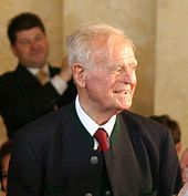
- Andreas Maurer (1919–2010) was Governor of Lower Austria from November 24, 1966 to January 22, 1981 .
- Otto Tschadek (1904–1969), Austrian Minister of Justice and Deputy Governor of Lower Austria
- Joachim Moser , active as an opera singer at the Vienna Volksoper .
- Michael Strasser is an Austrian extreme athlete . He set world records by crossing Russia , Africa and America on a racing bike.
literature
- Feigl: History of the market and the rule of Trautmannsdorf . Vienna 1974.
Web links
- Community website
- Website of the town of Gallbrunn
- an der Leitha Entry on Trautmannsdorf an der Leitha in the Austria Forum (in the AEIOU Austria Lexicon )
- 30726 - Trautmannsdorf an der Leitha. Community data, Statistics Austria .
Individual evidence
- ↑ Statistics Austria: Population on January 1st, 2020 by locality (area status on January 1st, 2020) , ( CSV )
- ^ A b Karl Buchleitner: Our village Stixneusiedel , 1985, p. 5 ( pdf , trautmannsdorf-leitha.gv.at, there p. 8).
- ↑ Statistics Austria: dissolutions or associations of municipalities from 1945
- ↑ a b History: The origin of the large community of Trautmannsdorf an der Leitha , trautmannsdorf-leitha.gv.at, accessed September 30, 2014.
- ^ Website of the Batthyány family
- ↑ Pictures from Trautmannsdorf Castle , hofmann.tv
- ^ Website of the Trachtenkapelle Trautmannsdorf
- ^ Website of the Stixneusiedl music association
- ↑ Expansion of the Trautmannsdorf wind farm raiffeisen.at, September 17, 2013, accessed August 21, 2018.


