Universitätsstrasse (Vienna)
| Universitätsstrasse | |
|---|---|
| Street in Vienna | |
| Basic data | |
| place | Vienna |
| District | 1st district , 9th district |
| Created | 1873 |
| Connecting roads | Alser Straße (continuation to the west) |
| Cross streets | Reichsratsstrasse , Ebendorferstrasse , Rathausstrasse , Landesgerichtsstrasse / Garnisongasse |
| Places | Roosevelt Square |
| Buildings | Vienna University |
| use | |
| User groups | Pedestrians , bicycle traffic , car traffic , underground line U2, tram lines 43, 44 |
| Technical specifications | |
| Street length | approx. 320 meters |
The University street in Vienna leading from the Schottentor on Universitätsring west side of the two-line and the beginning of the Alserstraße the Frankhplatz and forms the border between the 1st District of Vienna, Inner City , and the 9th District, Alsergrund . It was laid out in 1873, the year construction began on the main building of the University of Vienna, which is adjacent to the southern roadside . Next to it, the southern side of the street extends only to three blocks, the northern side only to two, because at the Schottentor the large Rooseveltplatz with the Votive Church , which visually dominates the area, and the Sigmund-Freud-Park adjoin the street to the north.
Location and characteristics
In the Middle Ages, the area belonged to the suburb outside the city wall in front of the Schottentor . After the first Turkish siege in 1529, in which the suburb was destroyed, it became part of the Josefstädter Glacis , which was kept free as a field of fire. In the 19th century there was a parade ground and parade ground here; it was given up after the emperor had decided in 1857 to demolish the city wall and the construction of the Vienna Ringstrasse on the glacis and mayor Cajetan von Felder had succeeded in convincing him to give up the square in favor of the new town hall district .
Universitätsstraße was now projected as the northern end of the uniformly planned and built town hall district between Ringstraße and Zweierlinie . It became a short, but important and heavily traveled street in the center of Vienna. Years before it was officially named, Vienna's first horse-drawn tramway line , operated by the private Viennese tramway company, ran from Schottentor to Wattgasse in Hernals through the road to the west from 1865 . As the newest form of public transport, the underground line U2 has been running since 1980 in the section Rathaus - Schottentor in the tunnel under a large part of the street.
The tram lines 43 and 44 (the "electric" one had replaced the horse-drawn tramway in 1901 and used these line signals from 1907 onwards) have been using the then newly built above-ground reversal loop at Jonas-Reindl at Schottentor since 1961 , run here in the middle of the street on their own track and set their own Continue west on Alser Straße . Cycle lanes can be used on both sides of the street.
The border between the 1st and 9th district is not in the middle of Universitätsstraße, as shown in the book plans, but according to the city administration's electronic city map directly on the edge of the building on the southern side of the street. All lanes and sidewalks on Universitätsstrasse are therefore part of the 9th district.
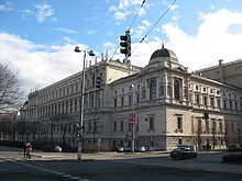
The buildings of the University of Vienna dominate Universitätsstrasse. The so-called new institute building is located two blocks west of the main building. In addition, other university facilities are housed in the few residential and commercial buildings. Therefore, the numerous passers-by on the street have a young, student, and international appearance. The architectural street scene (with the exception of the new institute building from the early 1960s) consistently consists of representative historic buildings that are listed as historical monuments , just like when the street was built in the last quarter of the 19th century .
building
(Houses with even numbers on the north side of the street in the 9th district, with odd numbers on the south side of the street in the 1st district)
No. 1: Main building of the University of Vienna
Almost half of the southern construction of Universitätsstrasse is taken up by the side of the main building of the University of Vienna , the main front of which is on Universitätsring 1. This large, representative ring road was built between 1873 and 1884 by Heinrich von Ferstel , who worked on the opposite Votive Church from 1856–1879 and on the building at Universitätsstrasse 2 diagonally behind it from 1873–1875. The university building is one of the most important examples of a late historical monumental building in Vienna and is unique in its own way. It is based on a complex floor plan based on the model of baroque monasteries and consists of two wings, each with four courtyards, which surround a large, arcaded inner courtyard. A ballroom on the front and the library wing on the back connect the two wings. The side front facing Universitätsstraße is structured by risalits and columns ( Ionic on the 1st floor, Corinthian on the 2nd floor). It is crowned by obelisks and figures by Johann Silbernagel and Anton Paul Wagner , who represent figures who symbolize the medical faculty.
No. 2
The main front of the neo-renaissance building around the corner has the address Rooseveltplatz 1–3. It was built between 1873 and 1875 by Heinrich von Ferstel and Karl Köchlin. Ferstel built the main building of the university and the Votive Church at the same time.
No. 3: Arcade house
The arcade house is on the corner of Reichsratsstrasse 15-17 opposite the rear of the university building. It was built in the form of the Viennese Neo-Renaissance 1881–1882 by Ludwig Tischler and expanded by Wilhelm Stiassny from 1887–1889 .
No. 4, 6, 8
The monumental residential and commercial building consisting of three house units was created by Ludwig Tischler in 1880–1881 . It is a strictly historical building with domed corner projections and a wide central projection and parapet balustrade . The individual foyers are designed differently with pilasters and square or barrel vaults .
From 1893 to 1900 the Arbeiter-Zeitung , the central organ of the Social Democrats , was printed here. The headquarters of the Adler Heraldic-Genealogical Society has been located at number 6 since 1999 , and at number 8 was the embassy of Tajikistan until 2016 .
No. 5: former Reitzes house
The former Reitzes house was built by Wilhelm Fraenkel in 1878–1879 . The remarkable corner house on Ebendorferstrasse is designed in the forms of the Viennese Neo-Renaissance. The side projection has a polygonal two-storey bay window which is supported by herms . The central projection of the side front, which also has balconies with pierced stone balustrades, is also supported by hermen. The foyer behind the banded column portal shows Ionic stucco marble columns, aediculan niches and a stucco coffered ceiling, the staircase has marble columns.
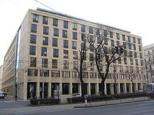
No. 7: New institute building
Here, which was previously corps command building Vienna of the army . It was built in 1871–1874 by Carl Wilhelm Christian von Doderer . In the large building complex there were important army services, including the military appeals court. In the First Republic after 1918, the Army Inspectorate and Brigade Commands I and II with the Vienna City Commanders were housed here. During the Nazi era , the building housed the city command and the military district command XVII, which was responsible for the Vienna region. However, the building was so badly damaged by bombs in 1945 that it was finally demolished in the late 1950s. The project of a new building for the university library failed.
In its place, Alfred Dreier and Otto Nobis built the new institute building of the University of Vienna between 1960 and 1962, the only building on Universitätsstrasse that interrupts the historicist ensemble. From 2002 a restoration took place in which the stone cladding of the facade was renewed. In addition, the loggias were built on Rathausstrasse and Ebendorferstrasse.
No. 9
The building is on the corner of Rathausstrasse 21 and was built by Anton Adametz from 1880–1881 in a strictly historical style.
No. 10
At the corner house to Garnisongasse there is a memorial plaque for the canon lawyer Willibald Plöchl from 2007, who fought against National Socialism out of legitimist convictions. He lived in the building from 1948 until his death in 1984.
No. 11
The corner house on Landesgerichtsstrasse was built by Ludwig Tischler in 1880–1881 . It is designed in the style of the Viennese Neo-Renaissance. It is structured by plinth arcades, the spandrels of which are richly decorated, by giant Corinthian pilasters in the area of the second and third floors and by column portals with balconies. In the vestibule there are Corinthian pilasters with Hermes heads, aediculan niches with female masks and a stucco ceiling.
The building was home to the Beethoven café, where students and writers like Anton Wildgans , Stefan Zweig and Hugo Bettauer , but also Sigmund Freud , frequented. Today the Café Stadtkind is open in its place.
No. 12: Suspenders House
The so-called Hosträgerhaus , a residential and commercial building, is located at the corner of Garnisongasse 1 and was built by Otto Wagner in 1887–1888 . Seen from the Landesgerichtsstrasse it is a striking eye-catcher. The unofficial, somewhat derisive name refers to vertical decorative ribbons on the main facade in Universitätsstrasse. The house has no direct vis-à-vis; it looks into the longitudinal axis of the Landesgerichtsstrasse, which is very wide here .
literature
- Felix Czeike : Historisches Lexikon Wien , Volume 5, Kremayr & Scheriau, Vienna 1997
- Bundesdenkmalamt (Ed.): Dehio-Handbuch Wien. I. District - Inner City . Berger, Horn 2003
Individual evidence
Web links
Coordinates: 48 ° 12 ′ 51.9 ″ N , 16 ° 21 ′ 28 ″ E


