
Währinger Strasse
| Währinger Strasse | |
|---|---|
| Street in Vienna | |
 |
|
| Währinger Straße in the 18th district at Gertrudplatz, out of town |
|
| Basic data | |
| place | Vienna |
| District | 9th district , 18th district |
| Connecting roads | Schottengasse (southeast), Thimiggasse (northwest) |
| Cross streets | Schwarzspanierstraße, Sensengasse, Spitalgasse, Währinger Gürtel, Kutschkergasse, Martinstraße, Weinhauser Gasse (selection) |
| Places | Rooseveltplatz, Ehrenhaft-Steindler-Platz, Gertrudplatz, Aumannplatz |
| Buildings | Volksoper |
| use | |
| User groups | Car traffic , bicycle traffic , pedestrians , tram lines 5, 33, 37, 38, 40, 41, 42, U6, bus lines 40A, S45 |
| Technical specifications | |
| Street length | approx. 3140 m |

The Währingerstraße is one of the main arterial roads in Vienna . It runs with a length of 3.14 kilometers from Maria-Theresien-Straße in the 9th district, Alsergrund , to Gersthof in the 18th district, Währing .
location
The Währinger Straße begins at the Schottentor , on the border between the inner city and the Alsergrund. At the Volksoper it crosses the Währinger Gürtel , the border between the 9th and 18th district, and changes its direction slightly from northwest to west-northwest. This is also where the Währinger Straße-Volksoper underground station is located on the U6 line, which is mostly at an elevated position on the Gürtel.
Other means of public transport through which Währinger Straße is developed are tram lines 37, 38, 40, 41 and 42 in the 9th district , and lines 40 and 41 in the 18th district. The tracks run west from Aumannplatz in Währing to the Gersthof station in the parallel Gentzgasse. Finally the street ends at the Gersthof station of the suburb line .
Street name
Währinger Straße is named after the municipality of Währing, which was independent until 1892 . The name became official in the 9th district in 1862 and in 1894 in the 18th district.
The name was first recorded as Warich around 1170 . There are only guesses as to the origin of the name. Possibly it is of Slavic ( var for warm spring) or Germanic origin ( werich for day work, ie a field the size of a man can work it in a day), possibly it is also derived from Werigandus, the first abbot of the Michelbeuern monastery , from. Another possible origin of the name could be traced back to the Slavic conquest, as Döbling ( Toplica = warm brook) and Währing ( Varica = dark brook) go back to Slavic toponyms .
The part from today's Sensengasse to Als (Spitalgasse) was called Hohlweg or Hollweg from 1801 . The name Neuburgerstraße - first mentioned in 1314 as Niuwenburger straze - for Währinger Straße appears in the land registers up to the area of today's Boltzmanngasse . The area from today's Van-Swieten-Gasse to Lazarett- or Spitalgasse was called Herzogspeint or Herzogspeundt around 1818 . In the 18th district the street was formerly called Zwanzigerzeile and Zweiunddreißigerzeile , later in Währing Hauptstraße and in Weinhaus Währing-Weinhauser Straße .
history


The street was first mentioned in documents in 1314. At that time, a Neuburger Straße was mentioned in the land register of the Schottenkloster . Until the 19th century, large parts of the ninth district were presented as floodplain landscape with numerous, later straightened, filled or vaulted watercourses; therefore this Neuburger Straße did not run directly to the north on the later Danube Canal .
After the two Turkish sieges, the area became a popular place for gardens of the nobility in the 18th century - such as the large Dietrichstein garden located directly on Währinger Gasse , in which the Palais Dietrichstein, today Palais Clam-Gallas , was later built, and that in the northeast adjoining, lower lying Liechtenstein Garden Palace . Medical institutions were established southwest of Währinger Gasse , to which the General Hospital was attached. Where the houses closest to the center of the street are today, the Glacis stretched as a free field of fire and landscape park in front of the city wall until 1858 to house number 9, corner of Schwarzspanierstraße and 16, corner of Berggasse .
The history of Währinger Straße in its current form began when the Als , which crossed the street at the current intersection with the Spitalgasse – Nussdorfer Straße in the 9th district, vaulted in 1840 and when in 1850 the suburbs were incorporated into the line wall to Vienna. Now the Währinger Straße was straightened and in 1855 extended uphill from the valley of the Als to the line wall.
The Währinger part between Gürtel and Martinstraße was for centuries the main street of a rural suburb (but since the middle of the 19th century it has grown into a small town), which can still be seen today in the winding course in contrast to the part on the Alsergrund , which is laid out like a visual axis . There the street was officially named Währinger Straße in 1862. In Währing it was still called Hauptstrasse and was paved there in the 1870s; in Weinhaus it was called Währing-Weinhauser Straße .
With the incorporation of many suburbs to Vienna, including Währing and Weinhaus, which was decided in 1890 and came into effect on January 1, 1892, the street was given its current length and in 1894 also its current name in Währing. The line office at the previous city limits was closed in 1891, the line wall leveled in 1893–1901. In 1898 the Volksoper was completed at the intersection of Währinger Strasse and Währinger Gürtel.
During this time the kk Stadtbahn (architecture: Otto Wagner ) was built, whose belt line opened in 1898 (since 1925, leased by the municipality of Vienna, electrified and in the tariff association with the tram, Wiener Elektro Stadtbahn , since 1989 underground line U6 ) crosses Währinger Straße as an elevated railway and serves the Währinger Straße-Volksoper station there. (From the street section in the 9th district you can see the beginning of the street section in the 18th district under the viaduct; however, since the street bends to the left here out of town, the further course of the street in Währing cannot be seen.)
The suburban railway line at the western end of Währinger Strasse was also put into operation in 1898; After decades of lack of passenger transport, it was resumed in 1987 by the ÖBB with the S 45 S-Bahn .
The district boundary between the 9th and 18th district ran one block within the Währinger belt, so that the Volksoper was part of the 18th district. The Lower Austrian provincial law of December 28, 1904 stipulated that this district border was relocated to the Gürtelstrasse. In the corresponding announcement by the Lower Austrian governor of June 7, 1905, it was specified that the new western border of the 9th district runs along the "western border of the Stadtbahn body" (thus the inner belt and the current subway route belong to the district) and apply from July 1, 1905. Since then, the Volksoper has been in the 9th district.
important addresses
Buildings with odd numbers are on the southwest or south side of the street, buildings with even numbers are on the northeast or north side.
9th district


- Section from Maria-Theresien-Straße to Spitalgasse / Nussdorfer Straße (numbers up to 69 and 78)
- No. 2–4: From 1861–1883, the provisional House of Representatives of the Reichsrat , ironized as Schmerlingtheater , stood here , until 1866 Parliament of the entire monarchy , from 1867 only the kingdoms and states represented in the Reichsrat . In 1867, the Reichsrat passed the December constitution, which was valid until the end of the Austrian monarchy in 1918 .
- No. 6–8: The seat of the naval section of the Austro-Hungarian War Ministry was located here from 1887–1908 . The Ministry itself was based at Am Hof at that time .
- No. 10: Old Chemical Institute, built by Heinrich von Ferstel in the Neo-Renaissance style (exposed brick) in 1869–1872 .
- No. 13: Anatomical Institute of the Medical University of Vienna (1950/1951) with the preserved middle section of the historicist building that was otherwise destroyed in the bombing war in 1945.
- No. 13A: Pharmacological Institute; Brick building, built in 1898.
- No. 19 , corner of Lackierergasse: quarter for homeless people and students under the name VinziRast in the middle of a Biedermeier house ; initiated by Cecily Corti ( Vinzenzgemeinschaft St. Stephan).
- No. 25: The Institute for the History of Medicine with an extraordinary collection of anatomical wax preparations from the 18th century is located in the baroque-classical Josephinum .
- No. 26: Memorial plaque for Mozart , who composed Così fan tutte here in a summer house in 1789/1790 .
- No. 30–36: Palais Clam-Gallas , previously Palais Dietrichstein, now used by the Lycée Français de Vienne , in a large private park.
- No. 38–42: In front of the Chemical and Physical Institute of the University of Vienna , erected in 1908–1915 at the junction of Boltzmanngasse on the site of a former poor welfare center and the kk tobacco control room , the monument designed by Wilhelm Frass and unveiled in 1935 stands successful chemist and entrepreneur Carl Auer von Welsbach , inventor of the incandescent gas light. An alley, a park and a street are named after him. 1956–1966 his portrait could be seen on the 20 Schilling note .
- No. 41: The composer Anton Bruckner lived here from 1868–1876 .
- No. 43: The Alsergrund district museum, which includes a Doderer memorial , an Erich Fried memorial room and a Schnitzler memorial, is located in the building of the district administration for the 9th district .
- No. 45: On the property at the corner of Spitalgasse there was once a public utility building that was demolished in 1928. Then the city administration created the large Arne Karlsson Park , so named in 1949 , in which there are monuments to the radiologist Guido Holzknecht and to the Swedish "Angel of Siberia", Elsa Brandström . An air raid shelter from the Second World War extends under the park.
- No. 48: Residence of the Sirota family of musicians with their daughter Beate Sirota , who drafted parts of the Japanese constitution on women's rights in 1945.
- No. 50: Opposite the Arne-Karlsson-Park, not far from the Strudlhofstiege , which he chose as the title for his most famous novel, lived the author Heimito von Doderer from 1956 until his death in 1966 . The furnishings in his study were given to the district museum by his widow (see no. 43).

No. 13: Medical University of Vienna
The Palais Clam-Gallas at nos. 30–36

Memorial for Carl Auer von Welsbach at No. 38

WUK , workshops and culture center, at No. 59

The Volksoper at No. 78; next belt


.JPG)
- Section from Spitalgasse / Nussdorfer Straße to the Währinger Gürtel
- No. 59: Impressive evidence of the early industrialization of Vienna is the former Georg Sigls locomotive factory at number 59. Locomotives, steam engines and steam boilers were produced here until 1873, when the plant had to close due to the so-called founder crisis . From Währingerstraße from the former Directorate and residential buildings with two is allegorical figures , technical science or engineering representing, to see above the arched entrance. From 1884 to 1979/1980, the extensive facility, consisting of several courtyards, housed the higher education and research institute called the Technologisches Gewerbemuseum . Since 1981, the buildings have housed the alternative culture and event center WUK (stairs 1–5) and the FZ - FrauenLesbenMigrantinnenGirlZentrum (“Frauenturm”, stairs 6).
- No. 78: On the corner plot of the Währinger Gürtel is the stage designed by Fellner & Helmer and opened in 1898 as the Kaiser-Franz-Josephs-Jubiläums-Stadttheater , since 1908 only called Volksoper , today one of the four federal theaters . It was part of the 18th district until 1905, when the district border was moved to the Gürtel.
18th district
In the course of the renewal of the underground water pipes in summer 2018, the (outer) Währinger Straße in the area between Gürtel and Aumannplatz was provided with some trees and seating, as well as pavement widenings in sections.
.JPG)


- Section from Währinger Gürtel to Martinstraße (numbers from 71 and 80)
- No. 81–83: The painter Hans Canon was born here in 1829 and spent his youth here.
- No. 95: At the Währinger parish church of St. Gertrud (first mentioned as a place of a chapel in 1213), Währinger Straße widens southwards to Gertrudplatz with the Kutschkermarkt, which continues in the Kutschkergasse that branches off from the square. Until 1769, when the Währing local cemetery was opened at the site of today's Schubert Park (see below), the Währing cemetery was located around the church.
- No. 114: The apartment building was built in 1892 according to plans by the architect Johann Hattey (1859–1904).
- No. 124: The town hall of the municipality of Währing, built from 1889 on a former inn area and since 1892 district office , expresses the self-confidence of the Viennese suburb in the late 19th century with its striking clock tower, visible from afar. The Währing district museum is also housed here. For the building, Martinstrasse was extended from Währinger Strasse to Gentzgasse (connection: Gymnasiumstrasse); the main entrance is at Martinstrasse 100. The building thus turned its back on what was then Vienna.
- Section from Martinstrasse to Simonygasse / Vorortelinie / Gersthofer Strasse
- No. 109–111: The plague cross from 1605 commemorates plague epidemics. In the 16th and 17th centuries the plague was recorded eleven times in Währing.
- No. 123: The pastor of Warich (called Währing in 1651) was mentioned for the first time in 1582. The Halterhaus next to the cemetery where he lived was demolished in 1907.
- Between No. 123 and 123A: The Schubertpark, opened in 1925, is located on the site of the Währing local cemetery, which opened in 1769 and closed in 1873. The grave grove contains the gravestones of Beethoven , Schubert , Nestroy , Grillparzer and others who were originally buried there.
- No. 143 to 159 : Aumannplatz with Norbert Liebermann Park and memorial
- No. 169–171 / Paulinengasse 15: From 1815, this was the summer residence of the journalist and conservative state thinker Friedrich von Gentz , the so-called Gentzschlössel in the form of a city villa . Gentz bought the property in 1819. The building was an important social meeting place for the political establishment in Vienna in the pre-March period . In 1927/1928, instead of the villa, a community building with 69 apartments was built according to the design by Konstantin Peller , which was named Toepler-Hof in 1965 after Rosa Toepler († 1916), who left the property to the community of Vienna for charitable purposes.
- No. 170: statue of Johannes Nepomuk
- No. 173–181: Until 1957, the Czartoryski-Schlössel , which Prince Konstantin Czartoryski bought in 1831 and named after him and which had been in the possession of the municipality of Vienna since 1912, stood here. After its demolition after 1955, a city school was opened in 1959. The first church in today's Weinhaus district existed in the castle, mentioned in 1807 .
- No. 176–178 / Köhlergasse 1–3: In 1929/1930, the Vienna City Planning Department built a municipal building with 35 apartments based on designs by Paul Fischel and Heinz Siller. Corner construction in the New Objectivity style with inserted loggias.
- No. 188–190: In 1926/1927 , the Vienna City Planning Department built a municipal building based on the design by Michael Rosenauer with 258 apartments on 15 stairs around an inner courtyard opposite the former Czartoryskischlössel (see No. 173–181) . This spacious, lower-lying courtyard is delimited to the street by a wide grille and two flanking street wings with beautiful corner balconies.
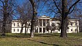
No. 169–171: Friedrich von Gentz's no longer existing residence , in 1918

The Toeplerhof at no. 169–171
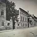
The no longer existing Czartoryskischlössel at no. 175–181, in 1918

No. 188–190: Municipal housing from the years 1926/1927


gastronomy
The Viennese coffee house culture is or was represented along Währinger Straße with some traditional, but also newer houses. The traditional houses in the 9th district included the Café Weimar, which still exists today, opposite the WUK, and in the 18th district the Café Wilder Mann (closed in 2009) and the Café Aumannhof . Until the 1990s, the Falstaff café opposite the Volksoper existed as a meeting place for artists. Allegedly, the author duo Carl Merz and Helmut Qualtinger met one of the role models for the character of "Mr. Karl" there . Café Stadlmann , which used to be a meeting place for students from the surrounding institutes, was closed in 2008 . A lively local scene has developed in the last decade in the part of Währinger Straße closest to the center around the Votivkino. The newer establishments here include restaurants that work with elements of system catering , as well as the student and trendy café Stein .
Tram traffic

From about 1817 reversed by the Freyung in today's 1st district to Weinhaus (now Währingerstraße 157) a Stellwagen , who no fixed timetable had but waited at the end stations each for passengers. From 1860 on, the Stellwagen continued to the current district of Pötzleinsdorf .
The modern traffic development of the Währinger Straße began when in 1869, starting from the Schottentor, a horse-drawn tram line to Nussdorfer Straße and on this to the Gürtel was put into operation. In 1883 the route in Währinger Strasse was extended from Nussdorfer Strasse to Währinger Gürtel and in 1884 from Gürtel to Vinzenzgasse in the Weinhaus district of the 18th district. In 1899 there was an extension from there through Gentzgasse to Simonygasse at the Gersthof station on the suburban line of the Vienna City Railway , which lies between Gentzgasse and Währinger Strasse.
In 1902/1903 the line was electrified along the entire Währinger Strasse; In the same year, the municipality of Vienna acquired the previously private line network, which was now run as a company called the municipality of Vienna, urban trams . Some of the tram sets running on Währinger Strasse were parked in the Kreuzgasse remise in the 18th district.
Since 1907 the line signals, which are still common today, have been running through Währinger Strasse (unless otherwise stated, to Aumannplatz in the 18th district) the lines (currently running in bold):
- 37 (section Schottentor – Nussdorfer Straße, 1907–1939 and 1953 to the present day)
- 38 (section Schottentor – Nussdorfer Straße, 1907–1944, 1945/1946 and 1952 to the present day)
- 39 (section Schottentor – Nussdorfer Straße, 1907–1944, 1945/1946 and 1952–1970)
- 40 (since 1980)
- 41 (1907 until today)
- 41A (1911-1924 and 1948-1965)
- 42 (section Schottentor – Gürtel, 1907–1945 and 1948 to the present day)
- E (1913-1917)
- E R (1907-1913)
- E K (1907-1917)
- E 2 (section Schwarzspanierstraße – Gersthof, 1924–1945 and 1946–1980, one of the two lines )
- F (section Schottentor – Gürtel, 1907–1945 and 1948–1960)
- G 2 (section Schwarzspanierstraße – Nussdorfer Straße, 1928–1945 and 1953–1980)
Trivia
The famous song Mariandl occurred to the composer Hans Lang on Währinger Strasse while traveling on tram line 41 in 1947.
gallery
The beginning of Währinger Strasse at Maria-Theresien-Strasse

At Thurngasse

In front of Sensengasse

In front of Spitalgasse / Nussdorfer Straße

At Wilhelm-Exner-Gasse

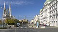
At the belt, on the right the Volksoper

In front of Martinstrasse

In front of Aumannplatz

At Paulinengasse

The end of the street at Simonygasse; behind the bridge of the suburb line


See also
literature
- Walter Krobot, Josef Otto Slezak, Hans Sternhart: Tram in Vienna - the day before yesterday and the day after tomorrow , Verlag Josef Otto Slezak, Vienna 1972, ISBN 3-900134-00-6
- Helmut Kretschmer: Viennese district culture guide. XVIII. Währing , Verlag Jugend und Volk, Vienna 1982, ISBN 3-7141-0492-5
- Bundesdenkmalamt (Ed.): Dehio -Handbuch. The art monuments of Austria. Vienna II. To IX. and XX. District. Edited by Wolfgang Czerny et al., Vienna 1993
- Felix Czeike : Historisches Lexikon Wien in six volumes (1992-2004), here in particular: Volume 5, Kremayr & Scheriau, Vienna 1997, ISBN 3-218-00547-7
- Wilhelm Urbanek: 9. - District Museum Alsergrund ( Wiener Geschichtsblätter , Supplement 3/2001), Association for the History of the City of Vienna, Vienna 2001
- Ferdinand Opll: Vienna in the picture of historical maps . Vienna 2004
- Peter Csendes , Ferdinand Opll : Vienna. History of a City , 3 vols. (2002–2005); Volume 3: From 1790 to the present , Vienna 2005
- Paul Katt, Doris Weis: 18. - District Museum Währing ( Wiener Geschichtsblätter , Supplement 2/2006), Association for the History of the City of Vienna, Vienna 2006
- Helmut Portele: "Wiener Tramwaymuseum" collection, self-published by the Wiener Tramwaymuseum collection, Vienna 2009, ISBN 978-3-200-01562-3
Web links
Individual evidence
- ↑ Art. VII § 2 Paragraph 2 lit. b Law of December 28, 1904, State Law and Ordinance Gazette for the Archduchy of Austria under the Enns, Vienna, No. 1/1905
- ^ State law and regulation gazette for the Archduchy of Austria under the Enns, Vienna, No. 104/1905
- ↑ Irene Suchy : Committed border crosser. wienerzeitung.at, January 15, 2013, accessed on March 25, 2013
- ↑ Währing. In: dasrotewien.at - Web dictionary of the Viennese social democracy. SPÖ Vienna (Ed.)
- ↑ Währing. In: dasrotewien.at - Web dictionary of the Viennese social democracy. SPÖ Vienna (Ed.)
- ↑ Rupert Leutgeb, Wolfgang Tauscher: Hans Lang - Melodies go around the world. Zwettl 2008, ISBN 978-3-901287-13-8 , p. 134 ff.
Coordinates: 48 ° 13 ′ 36.1 ″ N , 16 ° 20 ′ 28.8 ″ E