Gerger
| Gerger | ||||
|
||||

|
||||
| Basic data | ||||
|---|---|---|---|---|
| Province (il) : | Adıyaman | |||
| Coordinates : | 38 ° 2 ' N , 39 ° 2' E | |||
| Residents : | 3,605 (2018) | |||
| Telephone code : | (+90) 416 | |||
| Postal code : | 02700 | |||
| License plate : | 02 | |||
| Structure and administration (as of 2019) | ||||
| Mayor : | Erkan Aksoy ( AKP ) | |||
| Website: | ||||
| District of Gerger | ||||
| Residents : | 19,035 (2018) | |||
| Surface: | 668 km² | |||
| Population density : | 28 inhabitants per km² | |||
| Kaymakam : | Resul Ozdemir | |||
| Website (Kaymakam): | ||||
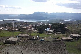
Gerger (formerly Alduş , Aramaic ܓܪܓܪ Gargar ) is a city and a district in the Turkish province of Adıyaman in southeastern Anatolia . The city of Gerger claims about 24.7 percent of the district's population. The district Gerger is located in the east of the province, bordering the provinces of Diyarbakir , Malatya and Şanlıurfa . In addition to the district town, there are 45 villages ( Köy ) with an average of 343 inhabitants. Gölyurt (1,439) and Güzelsu (1,266 pop .) Are the largest.
Originally, today's village of Oymaklı was called Gerger . When the administrative headquarters moved to what was then Alduş in 1954 , the place name Gerger was also transferred to Alduş .
The castle of Gerger (Gerger Kalesi) stands on a ridge above the west bank of the Euphrates near Gerger, the ancient Arsameia on the Euphrates . The complex was built by Arsames II (260–228 BC), one of the founders of the empire of Kommagene .
Individual evidence
- ↑ a b Türkiye Nüfusu İl İlçe Mahalle Köy Nüfusu (Nufusune.com) , accessed on May 5, 2019
- ↑ http://www.purcu.com/adiyaman.html , accessed March 10, 2010
- ↑ http://www.uni-kiel.de/kibidano/receive/kibidano_kibpic_00004606 , accessed March 11, 2010


