
Germanic grave (Itzehoe)


The so-called Itzehoer Germanengrab , which is also called "Itzehoer Galgenberg " according to its historical use , is reminiscent of one of the particularly impressive burial mounds of the Nordic Bronze Age in Schleswig-Holstein and is located on Timm-Kröger- Strasse / Langer Peter on the edge of downtown Itzehoe. It is an earth-covered domed structure made of brick masonry, the exterior of which is modeled on the original burial mound. The building was erected for propaganda purposes in 1938 during the Nazi era . It is divided into an entrance hall with a barrel vault and a domed structure with a circular floor plan. The structure overhangs three base graves of the Bronze Age necropolis , which, as a result of subsequent burials, had grown into a multi-layered, mighty barrow complex . This was later used as the gallows hill of the Itzehoe Cistercian monastery and was excavated and scientifically examined by Günther Haseloff on behalf of the Kiel Museum of Patriotic Antiquities in 1937 . The name Galgenberg is common but imprecise, as there were a total of four Galgenbergs in the city of Itzehoe, which were used simultaneously by the four historical jurisdictions as the respective place of execution . Three of them were burial mounds from the Bronze Age. From the Galgenberg, a wide view of the marshes was possible without today's urban development .
history
excavation
The burial mound known as Galgenberg, originally 5.5 m high, was scientifically examined by Günther Haseloff in 1937 on behalf of the Heimatverband für die Kreis Steinburg and the Kiel Museum of Patriotic Antiquities, as its preservation was endangered due to the increasing development of the surrounding area. After a search trench from the east uncovered two graves, a full excavation was undertaken. This unearthed 12 graves, of which ten were body burials in tree coffins and two contained the remains of cremation burials. Three men's and four women's graves could be identified from the grave goods. Eleven of the grave sites were burials of adult dead and one was that of a child. There are also reports of two later urn burials found in the mantle of the hill.
Because of its unusual height, the large number of burials and the undisturbed preservation of the twelve graves, the Galgenberg is one of the much-respected grave complexes in the Nordic District. The grave finds date its origin in the Nordic Older Bronze Age (period II and III after Oskar Montelius ). The arrangement and sequence of the tombs suggest a place of ancestor worship of a settler family and a burial continuity over at least six generations, which means that the necropolis was used for more than 200 years in the period between 1500 and 1200 BC. Suggests.
Plant and structure
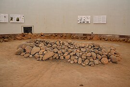
The grave complex developed from two adjacent burial mounds, of which the southern hill I was the older and enclosed the founder's grave, the stone remains of which are now covered by the dome of the building. Elevated next to the western trade route to the north-western Dithmarschen, the location on a geest knoll was chosen so that it also enabled a view of the wide marshland of Stör and Elbe. Hill I had a diameter of 13 m, a height of 2.70 m and was surrounded by a wreath of head-sized stones and stone blocks. The dead man was buried stretched out on his back in a tree coffin, which was enclosed in a stone wrap. Subsequently to the south, the considerably smaller Hill II housed women's grave 2 with a tree coffin, stone packing and stone wreath, as well as children's grave 3, which was foundless and consisted only of a tree coffin in a stone packing. These graves are now under the barrel vault of the entrance area.
The following graves 4 and 4a were placed on Hill II and covered with Hill III, which leaned almost at the same height on the first. So they now formed a burial mound complex with two knolls. The next two barrows docked on the ground in separate, overlapping hills on this complex and expanded the area to the north. The following hill VI transformed the entire grave ensemble into a uniform hill system with a height of 3.75 m.
Burials 8 and 9 were placed in a hollow (grave 8) or in a grave mound of only a small height on its top. After this simplistic departure from the old burial customs, the old burial mound culture in Hill VIII experienced an impressive renaissance: Above the conspicuously large grave 10, a new filling took place, which covered the entire burial complex. The tomb had now reached a height of five and a half meters and a base area with a diameter of 30 m.
Finds
The organic components of the burials were almost completely gone, with the exception of a textile belt remnant in grave 6, which was made in tablet weaving and wickerwork and could be reconstructed. Artefacts made of flint , bronze , clay and gemstones were mainly found as grave goods . In grave 1 only a fire stone and a piece of pebbles remained as parts of a lighter set. The dead woman in women's grave 2 was given a bronze wheel needle 25 cm in length as jewelry and clothing. This comes from the Lüneburg area and suggests trade relationships and probably also the origin of the wearer. The rich burial of a warrior in grave 4 contained his weapons: a sword made in the region, with wooden remains from the scabbard, and a heel ax. Other accessories were tweezers to take care of the beard hair, an unprocessed piece of amber and a hook as the remainder of a leather belt. A singular blue glass bead - worn over the chest - was of particular value at the time and testifies to trade relations with southern Germany. It is considered the oldest glass find in male graves in Schleswig-Holstein.
Clay vessels were found in graves 5 and 6. In the first-mentioned grave, there were two roughly-shaped, gray-brown beakers 6.5 cm and 8.8 cm high at the foot of the grave. The bulbous clay vessel from grave 6 was smoothly shaped with two knobs attached to the side and doubled in height at 17.6 cm. In addition, the women's grave 6 contained a bronze knife blade, the remainder of the woven belt end with attached plaited decoration, a decorative needle with a protruding head and a piece of urn resin. Grave 7 and grave 7a could be identified as men's and women's graves on the basis of the finds: the bronze bangle and the burned, twisted bronze neck ring from grave 7a are women's jewelry and the 22.9 cm long bronze dagger blade with broken tip from grave 7 is part of the armament. In men's grave 7 there was also a spiral plate fibula with a narrow bow from period II of the Nordic Bronze Age.
In grave 8 a green oxidized remnant of another Nordic fibula was found with an end spiral made of round wire and a spiral thickening needle head. The spiral plate fibula is assigned to the transition to period III of the Nordic Bronze Age. The small spiral fragment of grave 10 was made of hammered wire, which suggests an assignment to period III. Grave 9 was a woman's grave, in which three chain links made of amber, a bracelet with decorative patterns and a badly decomposed, multi-profiled bronze needle (southern Germany, period III) were found.
The additions from the Galgenberg show that the necropolis was used in Periods II and III of the Nordic Bronze Age. In addition, far-reaching trade relationships can be recognized from their origins as far as the Lüneburg area and southern Germany. The amount of work required to create the 5.5 m high grave mound and the value of the grave goods indicate an elevated social position and a productivity of the settler group that goes beyond the need for reproduction, which, in addition to land cultivation, suggests participation in trade.
National Socialism

Haseloff interpreted the twelve burials in nine construction periods due to the archaeologically verifiable long use as an ancestral cult place of a Bronze Age settler family, which he then addressed as "Bronze Age Teutons" on the basis of associated Roman Age text sources, from which he obtained the Germanic kinship law for all periods of time without any time-related scientific evidence complained about the tomb. The National Socialists followed up on this interpretation in the sense of their Germanic ideology and put the Bronze Age residents into a Germanic lineage due to the local agreement. This was to prove the long history of the so-called Germanic master race . The alleged connection between Bronze Age and Germanic forms of life and legal forms is scientifically unfounded because of the more than a thousand-year period and is not tenable against the background of the diverse unexplored migration movements.
Originally it was planned to fill the Galgenberg again after the excavation at the old height. Due to the significant research results, it was decided to preserve the hill and the three base graves as "consecration sites for the National Socialist German cult". A protective vault should be made for this. Based on the model of a similar Danish facility to protect the Viking ship from Ladby , which was excavated in 1934, plans were made to build a hill over the building. The surrounding area was to be redesigned into a park with a parade area for Itzehoe's National Socialist organizations. In addition, a home hall and a Hitler Youth home were to be built.
Only the three base graves of the necropolis have been preserved. After it was built over, the project was to be converted into the shape of a barrow by means of earth cover. The planning and construction of the project was the responsibility of Hans Rudolph, the Itzehoer Stadtbauratier, who, taking into account the iron-saving requirement, did without reinforced concrete in the war-preparation period and designed the building in local sand-lime brick. The Bronze Age findings were deliberately elevated with stylistic devices from sacral architecture to create a "awe-inspiring consecration hall of a Germanic ancestral clan". Rudolph covered grave 1 with a 9.20 m high dome, which also enclosed the stone circle with sufficient distance from the wall, while graves 2 and 3 were spanned by a 5.40 m high barrel vault. The entrance to the burial hall was placed on the north side of the barrel in order to achieve a space-increasing effect at the transition from the barrel to the dome.
After the dome was completed, the building was covered with earth to form a burial mound almost ten meters high . In time for the 700th anniversary of Itzehoe in 1938, this work was completed and the outdoor facilities of the Germanic grave were prepared, which were used as a parade area for the organizations of the National Socialist movement. The mound was misleadingly and incorrectly given the name Germanengrab , which is still used today .
A surrounding frieze was designed by Wilhelm Petersen , Elmshorn, to decorate the interior of the dome . It should represent a life-size, Germanic mourning congregation in a romantically transfigured, hero-worshiping (blond and blue-eyed) manner and be fifty meters long and two meters high. Because of the war and the associated shift in focus and lack of funds, it was not carried out.
- Photos from inside the dome


In the outer area, southeast of the hill of the Germanic grave, the remains of a Neolithic , enlarged dolmen ( large stone grave of Warringholz ) were built.

After the war, the parade area at the front of the grave was converted into a memorial for the dead and displaced persons of the world wars. The dome with the graves may by prior arrangement (in Kreismuseum Prinzeßhof include in Itzehoe); a restricted view is possible through the barred entrance gate.
Jurisdictions and gallows mountains in Itzehoe
Due to the historically evolved administrative structure, Itzehoe had four separate judicial districts (jurisdictions), each with its own gallows from 1617 to March 31, 1861.
- A stone castle was built by the Schauenburg counts around 1180 on a castle wall within the Störschleife . The medieval law of the castle applied. The associated Galgenberg is a Bronze Age burial mound (location) between the Struvestrasse and the Ringstrasse Galgenberg in the Wellenkamp district. The public execution of the robbery killer Johann Lau from Brokdorf took place there on December 18, 1856.
- Adolf IV von Schauenburg and Holstein founded the Neustadt next to the castle in 1238. The term Neustadt is still officially used today, but is to be seen in a historical context and today describes the oldest part of the settlement in Itzehoe. This merchant settlement was endowed with the Luebian law . The gallows hill of the Lübschen city was a Bronze Age burial mound (location) on Buchenweg east of the Lübschen fountain .
- In 1256 a Cistercian convent was founded in Itzehoe . During the Reformation in 1541 it was converted into a noble, evangelical women's monastery and still exists today. The still existing monastery courtyard next to the St. Laurentii Church is one of the oldest preserved areas in Itzehoe. The monastery had its own right. The gallows hill of the monastery (location) was the Germanic grave described here.
- The rule of Breitenburg . The gallows hill of the Breitenburg rule was on a hill northeast of the Kratt .
literature
- Ekkehard Aner and Karl Kersten : The finds of the older Bronze Age of the Nordic district in Denmark, Schleswig-Holstein and Lower Saxony, Volume 18, Steinburg district, edited by K. Kersten, ed. by K.-H. Willrodt with the assistance of H.-H. Standing, Neumünster 1993.
- Günther Haseloff : The Galgenberg from Itzehoe. A burial mound from the older Bronze Age . In: Offa , reports and communications on prehistory, early history and medieval archeology , vol. 3, Neumünster 1938, pp. 18–84.
- Ulf Ickeroth: Between burial mounds, ancestor cult, consecration place and uncomfortable memorial…. In: Steinburger Yearbook. Volume 58, 2014, pp. 39-81 ( online ).
- Ulf Ickeroth: Between an uncomfortable memorial and a staged memorial. In: Steinburger Yearbook. Volume 59, 2015, pp. 21-64 ( online ).
- Rudolf Irmisch : What the Germanic grave tells us. In: Ders .: Personalities and stories from Itzehoe's past. Christiansen, Itzehoe 1956, pp. 10-13.
- Karl Kersten: Prehistory of the district of Steinburg, The prehistoric and early historical monuments and finds in Schleswig-Holstein, 1. Prehistoric and early historical studies from the Museum of Prehistoric Antiquities in Kiel - Neumünster 1939.
- Ingo Lafrentz: The so-called Germanic grave (Galgenberg) in Itzehoe . In: Heimatverband Kreis Steinburg (Hrsg.): Steinburger Jahrbuch 2009. Itzehoe 2008, pp. 99-104.
- Ingo Lafrentz: Staged Germanism. The so-called Germanic grave in Itzehoe . In: Working group for research into National Socialism in Schleswig-Holstein e. V. (Ed.): Information on Schleswig-Holstein Contemporary History, Vol. 52/53, Kiel 2010/11, pp. 16–47 ( online )
- Hans Rudolph: Lime sandstone domed vault in the memorial hall of the Germanic grave of Itzehoe . Special publication of the specialist group sand-lime brick industry, Berlin 1939 ( PDF, 2.6 MB).
- Andrea Völter and Jörg Benz: The Galgenberg in Itzehoe, the "Germanengrab", Hrsg .: Heimatverband für die Kreis Steinburg, Itzehoe 2001.
- Lothar Wittorf: The Bronze Age graves of the Itzehoer Galgenberg - information board and showcase contents, publisher: Archäologische AG des Heimatverband für die Kreis Steinburg, Itzehoe 2018 (online )
- Lothar Wittorf: An uncomfortable monument - Galgenberg vs. "Germanengrab" , Ed .: Archäologische AG of the home association for the Steinburg district, Itzehoe 2013.
Web links
- Individual description of the graves and grave finds (PDF)
- Individual description of the graves and grave finds ( Memento from March 4, 2016 in the Internet Archive )
- Ventilation renovated: Germanic grave dry
- Website: http://www.geschichtenberg-itzehoe.de
Individual evidence
- ^ Günther Haseloff: The Galgenberg von Itzehoe . In: Offa . tape 3 . Neumünster 1938, p. 81 .
- ^ Günther Haseloff: The Galgenberg von Itzehoe . In: Offa . tape 3 . Neumünster 1938, p. 82 .
- ↑ Photo after completion with outdoor facilities