Gmina Chęciny
| Gmina Chęciny | ||
|---|---|---|

|
|
|
| Basic data | ||
| State : | Poland | |
| Voivodeship : | Holy Cross | |
| Powiat : | Kielecki | |
| Geographic location : | 50 ° 48 ' N , 20 ° 28' E | |
| Height : | 275 m npm | |
| Residents : | s. Gmina | |
| Postal code : | 26-060 | |
| Telephone code : | (+48) 41 | |
| License plate : | TKI | |
| Economy and Transport | ||
| Street : |
E 77 Krakow - Warsaw Kielce - Małogoszcz |
|
| Rail route : | Kielce – Jędrzejów | |
| Next international airport : | Krakow-Balice | |
| Gmina | ||
| Gminatype: | Urban-and-rural parish | |
| Gmina structure: | 18 school offices | |
| Surface: | 127.57 km² | |
| Residents: | 15.096 (June 30, 2019) |
|
| Population density : | 118 inhabitants / km² | |
| Community number ( GUS ): | 2604033 | |
| Administration (as of 2007) | ||
| Mayor : | Robert Jaworski | |
| Address: | pl. 2 Czerwca 4 26-060 Chęciny |
|
| Website : | www.checiny.pl | |
The Gmina Chęciny is an urban-and-rural municipality in the powiat Kielecki in the Świętokrzyskie Voivodeship in Poland . Its seat is the city of the same name with about 4400 inhabitants.
history
After an administrative reform, the municipality became part of the newly formed Kielce Voivodeship from 1975 to 1998 . After its dissolution, it became part of the Heiligkreuz Voivodeship.
structure
The urban-and-rural commune of Chęciny covers an area of 127.6 square kilometers. In addition to the town of Chęciny, the following 18 villages with school authorities belong to the rural community:
Bolmin, Gościniec, Korzecko, Lipowica, Łukowa, Miedzianka, Mosty, Ostrów, Podpolichno, Polichno, Przymiarki, Radkowice, Skiby, Siedlce, Starochęciny, Tokarnia, Wojkowiec and Wolica.
Attractions
The listed sights in the main town include:
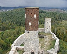
- Castle ruins from the 13th / 14th centuries century
- Town hall, built in 1837
- Monastery of the Poor Clares
- Former synagogue and Jewish cemetery
traffic
The S7 expressway , part of the European route 77 from Warsaw to Krakow , runs from north to south through the municipality. The DW 762 voivodship road leads to the cities of Małogoszcz in the west and Kielce in the northeast, about ten kilometers away . The voivodship road DW 763 leads to the state road DK 73.
Railway stops are in the Radkowice and Wolica municipalities on the Warszawa – Kraków railway line .
The nearest international airport is Kraków-Balice , about 90 kilometers from the main town of the municipality.
Web links
Individual evidence
- ↑ population. Size and Structure by Territorial Division. As of June 30, 2019. Główny Urząd Statystyczny (GUS) (PDF files; 0.99 MiB), accessed December 24, 2019 .


