Chęciny
| Chęciny | ||
|---|---|---|

|
|
|
| Basic data | ||
| State : | Poland | |
| Voivodeship : | Holy Cross | |
| Powiat : | Kielce | |
| Gmina : | Chęciny | |
| Area : | 14.13 km² | |
| Geographic location : | 50 ° 48 ' N , 20 ° 28' E | |
| Height : | 275 m npm | |
| Residents : | 4373 (December 31, 2016) | |
| Postal code : | 26-060 | |
| Telephone code : | (+48) 41 | |
| License plate : | TKI | |
| Economy and Transport | ||
| Street : |
E 77 Krakow - Warsaw Kielce - Małogoszcz |
|
| Rail route : | Kielce – Jędrzejów | |
| Next international airport : | Krakow-Balice | |
Chęciny is a city in Poland in the Świętokrzyskie Voivodeship . The city has about 4,200 inhabitants and is the seat of the city-and-country municipality of the same name .
history
The first written mention of Chęcinys comes from 1275 in a document by Bolesław Wstydliwys . It is not known exactly when the place received city rights . Most likely, King Władysław I granted Ellenlang the right in the first half of the 14th century. In 1306 a castle was built on a hill.
During the suppression of the uprisings under Mikołaj Zebrzydowski in 1607, the town and the castle were destroyed. The place was further destroyed during the Northern Wars against Sweden. During the third partition of Poland , Chęciny came to Austria and became a district town. With the formation of the Duchy of Warsaw , Chęciny became part of the same and in 1815 part of Congress Poland .
After the First World War , the city was again part of the restored independent state of Poland. In September 1939 the Wehrmacht invaded Chęciny. A ghetto was established during the occupation . In July 1941, the chairman of the Judenrat asked the district chief of Kielce, Karl Hans Drechsel , for support against two “rebels”. In 1945 the Red Army marched into the city, which subsequently became part of Poland again. In 1975 an administrative reform was carried out and Chęciny became part of the newly formed Kielce Voivodeship . After its dissolution, the city became part of the Świętokrzyskie Voivodeship.
Attractions
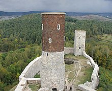
- Castle ruins from the 13th / 14th centuries century
- Town hall, built in 1837
- Baroque monastery of the Poor Clares
- Former synagogue and Jewish cemetery
local community
The urban-and-rural municipality Chęciny has an area of 127.57 square kilometers, on which about 14,700 inhabitants live.
traffic
Numerous large country roads lead through Chęciny. The most important is the European route 77 , which runs from north to south . This leads to Warsaw in the north and Krakow in the south . Immediately at Chęciny, the E 77 is formed by expressway 7 , which is about 24 kilometers long. The voivodship road 762 runs in an east-west direction. This opens about 15 kilometers west in the town of Małogoszcz . The 762 ends in Kielce about 13 kilometers to the northeast . The voivodship road 763 begins in Chęciny, but ends twelve kilometers further east with the confluence with the state road 73.
The Radkowice and Wolica stops on the Warszawa – Kraków railway line are in the municipality .
The nearest international airport is John Paul II International Airport Kraków-Balice . It is located about 90 kilometers south of Chęciny.
Web links
Individual evidence
- ↑ Doc. VEJ 4/310 in: Klaus-Peter Friedrich (edit.): The persecution and murder of European Jews by National Socialist Germany 1933–1945 (source collection) Volume 4: Poland - September 1939 – July 1941 , Munich 2011, ISBN 978-3-486-58525-4 , pp. 670-671.


