
Gmina Jutrosin
| Gmina Jutrosin | |||
|---|---|---|---|

|
|
||
| Basic data | |||
| State : | Poland | ||
| Voivodeship : | Greater Poland | ||
| Powiat : | Rawicki | ||
| Geographic location : | 51 ° 39 ' N , 17 ° 10' E | ||
| Residents : | s. Gmina | ||
| Postal code : | 63-930 | ||
| Telephone code : | (+48) 65 | ||
| License plate : | PRE | ||
| Economy and Transport | |||
| Next international airport : | Wroclaw | ||
| Gmina | |||
| Gminatype: | Urban-and-rural parish | ||
| Gmina structure: | 18 school offices | ||
| Surface: | 114.93 km² | ||
| Residents: | 7108 (June 30, 2019) |
||
| Population density : | 62 inhabitants / km² | ||
| Community number ( GUS ): | 3022023 | ||
| Administration (as of 2018) | |||
| Mayor : | Romuald Krzyżosiak | ||
| Address: | Rynek 26 63-930 Jutrosin |
||
| Website : | www.jutrosin.pl | ||

The Gmina Jutrosin [ ju'trɔɕin ] is a town-and-country municipality in the Powiat Rawicki of the Greater Poland Voivodeship in Poland . It has about 7100 inhabitants. Its seat is the city of the same name ( German Jutroschin ) with 1984 inhabitants (as of June 30, 2019).
geography
_location_map.png)
The community lies in the south of the province and is bordered to the south and east by the Province of Lower Silesia . The district town of Rawicz (Rawitsch) is 20 kilometers to the west, Posen about 90 kilometers to the north. The waters include the Orla (Horle) and the Radęca, which is dammed into a lake north of the town of Jutrosin .
The community has an area of 114.9 km², 78% is used for agriculture and 15% for forestry.
history
From 1975 to 1998 the municipality was part of the Leszno Voivodeship .
Parish partnership
Since 1993 there has been a partnership with the French community of Potigny in the Calvados department.
structure
The town-and-country community (gmina miejsko-wiejska) Jutrosin consists of the town itself and 18 villages with school administration offices (sołectwa):
| Surname | German name (1815-1919) |
German name (1939-1945) |
|---|---|---|
| Jutrosine | Jutroschin |
1939-1943 Orlahöh 1943-1945 Horlen |
| Bartoszewice | Bartoschewitz | Beards |
| Bielawy | Bilaven | Bismarck Seich (Kr. Militsch) |
| Domaradzice | Domaradzitz | Urn field |
| You Am | You Am |
1939–1943 Spitzwald 1943–1945 Spitzwall |
| Grąbkowo | Grombkowo 1911-1919 Gromkow |
Streudorf |
| Janowo | Janowo | House forest |
| Jeziora | Jeziora | Peat willow |
| Nad Stawem | Nadstawem 1905-1919 Grünweiler |
Grünweiler |
| Nowy Sielec | New Sielec |
1939–1943 Neusiedel 1943–1945 Schellitz |
| Ostoje | Ostoje | Location |
| Pawłowo | Pavlovo | Paulseck |
| Płaczkowo | Platschkowo 1905-1919 Lindenort |
Lindenort |
| Rogożewo | Rogozewo | Hornau |
| Śląskowo | Slonskowo | Sun Valley |
| Szkaradowo | Szkaradowo | German Defense |
| Szymonki | Szymonki (older Simunke) | Möhringen |
| Zaborowo | Zaborowo 1905-1919 Bismarckseich |
Bismarckseich |
| Zmysłowo | Zmyslowo 1905–1919 Grunewald older Zmislave |
Grunwald |
Settlements, hamlets and districts are:
| Surname | German name (1815-1919) |
German name (1939-1945) |
|---|---|---|
| Bonowo | Bonowo | German Defense East |
| Börek | ( to Domaradzitz ) | ( to Urnenfeld ) |
| Debina | Dembina | ? |
| Katarzynowo | Katarzynowo | German defense dismantling |
| Ochłoda | Vorwerk Ochloda | ? |
| Piskornia | Piskornia | Fasanenhof |
| Stary Sielec | Old Sielec | Old settlement |
| Stasin | Stasin | Hauswald-South |
| Wielki Bór | Wielkibor | Waldhof |
| Żydowski Bród | Judenfurth | Hard edge |
| Zybki | Zybki | Hauswald-North |
| Zygmuntowo | Zygmuntowo | Siegmundshof |
Architectural monuments
Sights placed under protection that are registered with the voivodeship as architectural monuments:
- Cemetery church with bell tower in Jutrosin (1777)
- Former Protestant church and cemetery in Jutrosin (1862–1863)
- Church of St. Elisabeth in Jutrosin (1900–1903)
- Classicist town hall in Jutrosin (1840)
- Windmill near Dubin (1797)
- Barns in Dubin (19th century)
- Church of St. Martin in Szkaradowo (1810–1812)

Town hall in Jutrosin

Windmill at Dubin
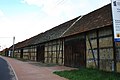
Barns in Dubin

Church in Szkaradowo


traffic
The national road DK36 runs through the north of the municipality. There is no rail connection.
The nearest international airport is the Nicolaus Copernicus Airport in Wroclaw, about 70 kilometers south .
Personalities
- Prince Adam Czartoryski (1845–1912), owner of the Wielki Bór estate and member of the German Reichstag
- Idzizlaw Czartoryski (1859–1909), member of the German Reichstag; died in Sielec
- Conrad von Schubert (1847–1924), Prussian lieutenant general; born in Wielkibor
- Richard von Schubert (1850–1933), Prussian officer; born in Wielkibor.
Web links
Individual evidence
- ↑ population. Size and Structure by Territorial Division. As of June 30, 2019. Główny Urząd Statystyczny (GUS) (PDF files; 0.99 MiB), accessed December 24, 2019 .
- ↑ a b Joh. Jakob Lidl: Novissimum Silesiae Theatrum. In: mapy.mzk.cz. Map collection Moll, 1745, accessed on February 14, 2020 .