
Potigny
| Potigny | ||
|---|---|---|

|
|
|
| region | Normandy | |
| Department | Calvados | |
| Arrondissement | Caen | |
| Canton | Falaise | |
| Community association | Pays de Falaise | |
| Coordinates | 48 ° 58 ′ N , 0 ° 15 ′ W | |
| height | 125-206 m | |
| surface | 4.26 km 2 | |
| Residents | 2,075 (January 1, 2017) | |
| Population density | 487 inhabitants / km 2 | |
| Post Code | 14420 | |
| INSEE code | 14516 | |
| Website | www.potigny.fr | |
 Old town hall with school (Mairie-Ecole) of Potigny |
||

Potigny is a municipality with 2,075 inhabitants (as of January 1, 2017) in the Calvados department in Normandy in north-western France . The municipality belongs to the arrondissement of Caen and the canton of Falaise (until 2015: canton of Falaise-Nord ). The inhabitants are called Potignais .
geography
Potigny is about 25 kilometers south-southeast of Caen . Potigny is surrounded by the neighboring communities of Soumont-Saint-Quentin in the north and east, Bons-Tassily in the south and east and Fontaine-le-Pin in the west.
Population development
| year | 1962 | 1968 | 1975 | 1982 | 1990 | 1999 | 2006 | 2012 |
| Residents | 2,926 | 2,720 | 2,408 | 2.120 | 1,776 | 1,703 | 1,719 | 1,886 |
| Source: Cassini and INSEE | ||||||||
Attractions
- Notre-Dame-du-Rosaire church from the 13th century, a historic monument since 1930
- Old girls' school, today's town hall
- Old town hall with school
- Houses of the mine administration
- Wash houses

Notre-Dame-du-Rosaire church

Old girls' school, today's town hall
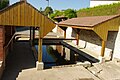
Wash house


Community partnerships
Partnerships have existed with the Polish municipality of Jutrosin in the Greater Poland Voivodeship since 1993 and with the British municipality of Banwell in Somerset (England) since 1999.
Personalities
- Maurice De Muer (1921–2012), racing cyclist