
Émiéville
| Émiéville | ||
|---|---|---|
|
||
| region | Normandy | |
| Department | Calvados | |
| Arrondissement | Caen | |
| Canton | Troarn | |
| Community association | Val ès Dunes | |
| Coordinates | 49 ° 9 ′ N , 0 ° 13 ′ W | |
| height | 4–22 m | |
| surface | 3.92 km 2 | |
| Residents | 588 (January 1, 2017) | |
| Population density | 150 inhabitants / km 2 | |
| Post Code | 14630 | |
| INSEE code | 14237 | |
 Entrance |
||

Émiéville is a French municipality with 588 inhabitants (as of January 1 2017) in the department of Calvados in the region of Normandy . It belongs to the arrondissement of Caen and the canton of Troarn . The inhabitants are known as Émiévillais .
geography
Émiéville is about 12 kilometers east-southeast of the center of Caen . The municipality is surrounded by Banneville-la-Campagne in the north-west and north, Saint-Pair in the north-east and east, Argences in the south-east, Bellengreville in the south, Frénouville in the south-west and Cagny in the west.
Population development
| year | 1793 | 1831 | 1876 | 1926 | 1946 | 1968 | 1990 | 2016 |
| Residents | 180 | 196 | 168 | 111 | 75 | 198 | 356 | 598 |
| Source: Cassini, EHESS and INSEE | ||||||||
Attractions
- Nativité-de-Notre-Dame church from 1958; the new building is located on the site of a church that was destroyed during the Second World War in 1944, the bell tower of which was classified as a monument historique
- Castle from the 16th / 17th centuries Century, since 1973 Monument historique
- Entrance portal from the 18th century, monument historique since 1972

Nativité-de-Notre-Dame church
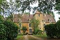
lock

Schlösshof portal


Web links
Commons : Émiéville - collection of images, videos and audio files