
Villers-Canivet
| Villers-Canivet | ||
|---|---|---|
|
||
| region | Normandy | |
| Department | Calvados | |
| Arrondissement | Caen | |
| Canton | Falaise | |
| Community association | Pays de Falaise | |
| Coordinates | 48 ° 56 ′ N , 0 ° 15 ′ W | |
| height | 139-233 m | |
| surface | 12.24 km 2 | |
| Residents | 771 (January 1, 2017) | |
| Population density | 63 inhabitants / km 2 | |
| Post Code | 14420 | |
| INSEE code | 14753 | |
 Town hall (Mairie) of Villers-Canivet |
||

Villers-Canivet is a municipality with 771 inhabitants (as of January 1, 2017) in the Calvados department in Normandy in north-western France . The municipality belongs to the arrondissement of Caen and the canton of Falaise (until 2015: canton of Falaise-Nord ). The inhabitants are called Villersois .
geography
Villers-Canivet is located about 27 kilometers south-southeast of Caen . This is where the laizon rises . Villers-Canivet is surrounded by the neighboring communities of Bons-Tassily in the north and northeast, Soulangy in the east, Saint-Pierre-Canivet in the east and southeast, Martigny-sur-l'Ante and Noron-l'Abbaye in the south, and Leffard in the west Southwest and Ussy in the west.
history
In 1821 the small municipality of Torp was attached to the municipality of Villers-Canivet .
Population development
| year | 1962 | 1968 | 1975 | 1982 | 1990 | 1999 | 2006 | 2012 |
| Residents | 452 | 460 | 459 | 476 | 497 | 502 | 667 | 754 |
| Source: Cassini and INSEE | ||||||||
Attractions
- Saint-Vigor church, partly from the 11th century, monument historique since 1946
- Former Cistercian convent of Les Dames from the 12th century, monument historique since 1994
- Ruins of the Sainte-Vierge church in Torp, a monument historique since 2003
- Town hall, built at the beginning of the 20th century
- Menhir La Grurie
- Wash houses

Saint-Vigor church

Portal of the Cistercian monastery

Ruins of the Sainte-Vierge church
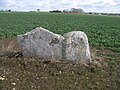
Menhir La Grurie


