
Saint-Pierre-Canivet
| Saint-Pierre-Canivet | ||
|---|---|---|
.svg)
|
|
|
| region | Normandy | |
| Department | Calvados | |
| Arrondissement | Caen | |
| Canton | Falaise | |
| Community association | Pays de Falaise | |
| Coordinates | 48 ° 56 ′ N , 0 ° 13 ′ W | |
| height | 142-231 m | |
| surface | 7.01 km 2 | |
| Residents | 400 (January 1, 2017) | |
| Population density | 57 inhabitants / km 2 | |
| Post Code | 14700 | |
| INSEE code | 14646 | |
 Town hall (Mairie) of Saint-Pierre-Canivet |
||

Saint-Pierre-Canivet is a municipality with 400 inhabitants (as of January 1, 2017) in the Calvados department in Normandy in north-western France . The municipality belongs to the arrondissement of Caen and the canton of Falaise (until 2015: canton of Falaise-Nord ). The inhabitants are called Canivetois .
geography
Saint-Pierre-Canivet is located about 30 kilometers south-southeast of Caen . Saint-Pierre-Canivet is surrounded by the neighboring communities of Soulangy in the north, Épaney in the northeast, Versainville in the east, Aubigny in the east and southeast, Noron-l'Abbaye in the south and Villers-Canivet in the west and northwest.
Population development
| year | 1962 | 1968 | 1975 | 1982 | 1990 | 1999 | 2006 | 2013 |
| Residents | 303 | 334 | 281 | 338 | 381 | 342 | 361 | 401 |
| Source: Cassini and INSEE | ||||||||
Attractions
- Saint-Pierre church from the 18th century
- La Tour Castle, built in 1769, has been a monument historique since 1967
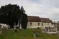
Saint-Pierre church

La Tour Castle


Web links
Commons : Saint-Pierre-Canivet - Collection of images, videos and audio files