
Cagny (Calvados)
| Cagny | ||
|---|---|---|

|
|
|
| region | Normandy | |
| Department | Calvados | |
| Arrondissement | Caen | |
| Canton | Troarn | |
| Community association | Val ès Dunes | |
| Coordinates | 49 ° 9 ′ N , 0 ° 15 ′ W | |
| height | 13–32 m | |
| surface | 8.46 km 2 | |
| Residents | 1,910 (January 1, 2017) | |
| Population density | 226 inhabitants / km 2 | |
| Post Code | 14630 | |
| INSEE code | 14119 | |
| Website | www.cagny.fr | |

Cagny is a French commune with 1,910 inhabitants (as of January 1 2017) in the department of Calvados in the region of Normandy ; it belongs to the arrondissement of Caen and the canton of Troarn .
geography
Cagny is about five kilometers east-southeast of Caen . Cagny is surrounded by the neighboring communities of Giberville in the north and north-west, Démouville in the north, Banneville-la-Campagne in the north and north-east, Émiéville in the east, Frénouville in the south and south-east, Grentheville in the west and Mondeville in the west and north-west. The A13 car route runs along the northern edge of the municipality and the A813 car route at the eastern edge .
Population development
| year | 1962 | 1968 | 1975 | 1982 | 1990 | 1999 | 2006 | 2013 |
|---|---|---|---|---|---|---|---|---|
| Residents | 710 | 1,021 | 994 | 878 | 1,650 | 1,592 | 1,503 | 1,495 |
Source: INSEE
Attractions
- Saint-Germain church from the 14th century, monument historique since 1913
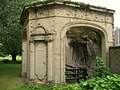
- Remnants of the Notre-Dame-des-Moutiers priory, Monument historique since 1974
- Notre-Dame-des-Sept-Douleurs chapel
- Sainte-Radegonde fountain

Saint Germain Church

Ruins of the old priory
Sainte-Radegonde fountain


Community partnerships
There is a partnership with the British community of Pirbright in Surrey .