
Fontaine-le-Pin
| Fontaine-le-Pin | ||
|---|---|---|

|
|
|
| region | Normandy | |
| Department | Calvados | |
| Arrondissement | Caen | |
| Canton | Falaise | |
| Community association | Pays de Falaise | |
| Coordinates | 48 ° 58 ′ N , 0 ° 17 ′ W | |
| height | 108-203 m | |
| surface | 8.54 km 2 | |
| Residents | 357 (January 1, 2017) | |
| Population density | 42 inhabitants / km 2 | |
| Post Code | 14190 | |
| INSEE code | 14276 | |

Fontaine-le-Pin is a French municipality with 357 inhabitants (as of January 1 2017) in the department of Calvados in the region of Normandy . It belongs to the arrondissement of Caen and the canton of Falaise . The residents are known as Fontaine-Brayens .
geography
Fontaine-le-Pin is located about eleven kilometers north-northwest of Falaise and 26 kilometers south of Caen . The municipality is surrounded by Saint-Germain-le-Vasson in the north, Potigny in the east, Bons-Tassilly in the southeast, Ussy in the south, Martainville in the southwest, Cesny-les-Sources with Tournebu in the west and Moulines in the northwest.
Population development
| year | 1793 | 1836 | 1876 | 1926 | 1946 | 1968 | 1990 | 2016 |
| Residents | 265 | 442 | 347 | 275 | 149 | 258 | 279 | 358 |
| Source: Cassini, EHESS and INSEE | ||||||||
Attractions
- Saint-Aubin de Bray-en-Cinglay church from the 12th century, a historic monument since 1976
- Saint-Pierre church, reconstruction from 1957, monument historique since 2005
- Remains of a former commandery ( French commanderie ) of the Knights Templar
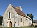
Saint-Aubin de Bray-en-Cinglay church

Saint-Pierre church


literature
- Le Patrimoine des Communes du Calvados. Volume 1, Flohic Editions, Paris 2001, ISBN 2-84234-111-2 , pp. 326-327.
Web links
Commons : Fontaine-le-Pin - collection of images, videos and audio files
- General information on Fontaine-le-Pin on communes.com ( French )
Individual evidence
- ^ Church of Saint-Aubin de Bray-en-Cinglay in the Base Mérimée of the French Ministry of Culture (French)
- ^ Church of Saint-Pierre in the Base Mérimée of the French Ministry of Culture (French)