
Fleury-sur-Orne
| Fleury-sur-Orne | ||
|---|---|---|
|
||
| region | Normandy | |
| Department | Calvados | |
| Arrondissement | Caen | |
| Canton | Caen-5 | |
| Community association | Caen la Mer | |
| Coordinates | 49 ° 9 ′ N , 0 ° 23 ′ W | |
| height | 2-66 m | |
| surface | 6.75 km 2 | |
| Residents | 4,915 (January 1, 2017) | |
| Population density | 728 inhabitants / km 2 | |
| Post Code | 14123 | |
| INSEE code | 14271 | |
| Website | www.fleurysurorne.fr | |
 Town hall of Fleury-sur-Orne |
||

Fleury-sur-Orne is a commune with 4915 inhabitants (as of January 1 2017) in the department of Calvados in the region of Normandy . Fleury-sur-Orne is part of the Caen arrondissement and the Caen-5 canton . The inhabitants are called Fleurysia .
geography

Fleury-sur-Orne is on the Caen plain on the Orne River . Fleury-sur-Orne is surrounded by the neighboring communities Louvigny in the north and west, Caen in the north-east, Ifs in the east and south-east, Saint-Martin-de-Fontenay in the south and Saint-André-sur-Orne in the south-west.
Route nationale 814 runs through the municipality .
history
The approximately 20 hectare necropolis of Fleury-sur-Orne is a Neolithic necropolis of the Passy type with 12 to 350 m long tumuli of the Cerny culture , which was excavated in Fleury-sur-Orne until 2016. Already in 1077, the place was as Alemannia mentioned and kept that name in French form ( Allemagnes , Allemagne ) until 1916. Whether the name to a camp of the Alemanni back is doubtful but not ruled out. It probably refers to Roman soldiers of Alemannic descent who settled with their families in what is now northern France as part of the Litus Saxonicum towards the end of the 3rd century or the beginning of the 4th century. Due to the war with the Germans, the municipality decided to give itself its current name based on the destroyed municipality of Fleury-devant-Douaumont . Even today, the municipality is divided into the districts of Haute-Allemagne and Basse-Allemagne .
In 1047 the Norman insurgents were driven here into the Orne from the battle of Val-ès-Dunes . The municipality is of economic and historical importance because the ocher-colored limestone, the so-called Pierre de Caen , has been mined here since the 11th century .
Population development
| year | 1962 | 1968 | 1975 | 1982 | 1990 | 1999 | 2006 | 2011 |
| Residents | 2,344 | 2,817 | 2,861 | 3,650 | 3,861 | 4.231 | 4,039 | 4,208 |
| Source: Cassini, EHESS and INSEE | ||||||||
Attractions
- Saint-Martin church in Haute-Allemagne
- Notre-Dame de Basse-Allemagne church, rebuilt in 1845 in neo-Gothic style, with a bell tower from the 11th century with additions up to the 12th century, monument historique since 1913
- 18th century bourgeois house on Rue Saint-André (No. 71), Monument historique since 2009
- Railway bridge
- Île Enchantée, Orne river island

Notre-Dame de Basse-Allemagne church
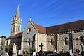
Saint-Martin church in Haute-Allemagne

Town house at 71 rue Saint-André


Community partnerships
With the Senegalese community Ouonck-Dieba with the German community Waldbuettelbrunn in Bavaria since 1994 consist partnerships .
Personalities
- Nikolaus von Oresme (around 1330–1382), Bishop of Lisieux, scientist
- Jean-Pierre François de Chazot (1739–1797), general during the French Revolution
- Pierre Gouget (1932–2003), racing cyclist
literature
- Le Patrimoine des Communes du Calvados. Volume 1, Flohic Editions, Paris 2001, ISBN 2-84234-111-2 , pp. 480-483.
Web links
- General information on Fleury-sur-Orne on communes.com (French)