
Espins
| Espins | ||
|---|---|---|
|
||
| region | Normandy | |
| Department | Calvados | |
| Arrondissement | Caen | |
| Canton | Thury-Harcourt | |
| Community association | Cingal-Suisse Normande | |
| Coordinates | 49 ° 1 ′ N , 0 ° 7 ′ W | |
| height | 90-186 m | |
| surface | 4.58 km 2 | |
| Residents | 245 (January 1, 2017) | |
| Population density | 53 inhabitants / km 2 | |
| Post Code | 14220 | |
| INSEE code | 14248 | |
 View of Espins |
||


Mairie of the parish
Espins is a French municipality with 245 inhabitants (as of January 1 2017) in the department of Calvados in the region of Normandy . It belongs to the arrondissement of Caen and the canton of Thury-Harcourt .
geography
Espins is about 20.5 kilometers northwest of Falaise and 23 km south of Caen . The community is surrounded by:
- Saint-Laurent-de-Condel in the north,
- Fresney-le-Vieux in the east,
- Cesny-les-Sources with Cesny-Bois-Halbout in the southeast and Placy in the south and southwest,
- Croisilles in the west,
- Les Moutiers-en-Cinglais in the north-west.
Population development
| year | 1793 | 1836 | 1876 | 1926 | 1946 | 1968 | 1990 | 2016 |
| Residents | 262 | 274 | 267 | 146 | 134 | 158 | 199 | 237 |
| Source: Cassini, EHESS and INSEE | ||||||||
Attractions
- Parish church of Saint-Pierre from the 12th century, parts from the 18th / 19th century. Century, classified as a cultural heritage
- “Town Hall School” from 1878, cultural heritage
- Lavoir (wash house)
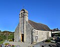
Saint-Pierre church

Wash house
.jpg)
.jpg)
Web links
Commons : Espins - collection of images, videos and audio files
- General information about Espins on communes.com ( French )