
La Hoguette
| La Hoguette | ||
|---|---|---|
|
||
| region | Normandy | |
| Department | Calvados | |
| Arrondissement | Caen | |
| Canton | Falaise | |
| Community association | Pays de Falaise | |
| Coordinates | 48 ° 53 ′ N , 0 ° 10 ′ W | |
| height | 89-267 m | |
| surface | 24.44 km 2 | |
| Residents | 714 (January 1, 2017) | |
| Population density | 29 inhabitants / km 2 | |
| Post Code | 14700 | |
| INSEE code | 14332 | |
 View of the community |
||


La Hoguette ( ) is a French municipality with 714 inhabitants (as of January 1 2017) in the department of Calvados in the region of Normandy . It belongs to the arrondissement of Caen and the canton of Falaise . The residents are known as the Hoguetons .
geography
La Hoguette is around 4 km southeast of Falaise , which it borders in the north. The municipality is also surrounded by Pertheville-Ners in the northeast, Vignats in the east, Nécy in the southeast, Rônai in the south, Neuvy-au-Houlme in the southwest, Cordey in the west and Saint-Pierre-du-Bû in the northwest.
history
The ancient Neolithic La Hoguette group was named in 1983 by the French prehistorian Christian Jeunesse after finds in a megalithic grave in the municipality.
Population development
| year | 1793 | 1836 | 1876 | 1926 | 1946 | 1968 | 1990 | 2016 |
| Residents | 422 | 684 | 631 | 402 | 425 | 464 | 532 | 718 |
| Source: Cassini, EHESS and INSEE | ||||||||
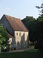
Attractions
- Saint-Barthélemy parish church from the 18th century
- Saint-André-de-Gouffern Monastery from 1127, classified as a Monument historique since 1932
- several castles and manor houses from the 18th and 19th centuries

Parish Church of Saint Barthélemy
The monastery building


Web links
- General information and pictures of La Hoguette on communes.com ( French )
Individual evidence
- ↑ Commune de La Hoguette (14332) - INSEE
- ^ Monastery of Saint-André-de-Gouffern in the Base Mérimée of the French Ministry of Culture (French)