
Mutrécy
| Mutrécy | ||
|---|---|---|
|
||
| region | Normandy | |
| Department | Calvados | |
| Arrondissement | Caen | |
| Canton | Thury-Harcourt | |
| Community association | Cingal-Suisse Normande | |
| Coordinates | 49 ° 4 ′ N , 0 ° 25 ′ W | |
| height | 7-104 m | |
| surface | 6.71 km 2 | |
| Residents | 359 (January 1, 2017) | |
| Population density | 54 inhabitants / km 2 | |
| Post Code | 14220 | |
| INSEE code | 14461 | |
 Mairie of the parish |
||

Mutrécy is a French municipality with 359 inhabitants (as of January 1 2017) in the department of Calvados in the region of Normandy . It belongs to the arrondissement of Caen and the canton of Thury-Harcourt . The inhabitants are known as Mutrécyens .
geography
Mutrécy is about 14 kilometers south-southwest of Caen and is bounded in the west by the Orne . The municipality is surrounded by Clinchamps-sur-Orne in the northeast, Boulon in the east and southeast, Grimbosq in the south and southwest, Maizet in the west and Amayé-sur-Orne in the northwest.
Population development
| year | 1793 | 1836 | 1876 | 1926 | 1946 | 1968 | 1990 | 2016 |
| Residents | 319 | 412 | 280 | 176 | 190 | 189 | 219 | 359 |
| Source: Cassini, EHESS and INSEE | ||||||||
Attractions
- 11th century Saint-Clair church, the portal of which has been classified as a monument historique since 1913
- Mansion
- old trainstation
- Lavoir (wash house)
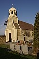
Saint Clair Church

Portal of the Church

Mansion
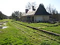
railway station


literature
- Le Patrimoine des Communes du Calvados. Volume 1, Flohic Editions, Paris 2001, ISBN 2-84234-111-2 , pp. 341-342.
Web links
Commons : Mutrécy - collection of images, videos and audio files
- Information on Mutrécy on communes.com ( French )
Individual evidence
- ^ Mutrécy - Cassini
- ↑ Saint-Clair Church in the Base Mérimée of the French Ministry of Culture (French)