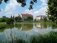
Gmina Opatówek
| Gmina Opatówek | ||
|---|---|---|

|
|
|
| Basic data | ||
| State : | Poland | |
| Voivodeship : | Greater Poland | |
| Powiat : | Kaliski | |
| Geographic location : | 51 ° 44 ' N , 18 ° 14' E | |
| Residents : | s. Gmina | |
| Postal code : | 62-860 | |
| Telephone code : | (+48) 62 | |
| License plate : | PKA | |
| Economy and Transport | ||
| Street : |
A2 / E30 Berlin – Poznan – Warsaw DK12 Kalisz - Łódź |
|
| Rail route : | Łódź – Ostrów Wielkopolski | |
| Next international airport : | Łódź | |
| Gmina | ||
| Gminatype: | Urban-and-rural parish | |
| Gmina structure: | 27 localities | |
| Surface: | 104.20 km² | |
| Residents: | 10,810 (Jun. 30, 2019) |
|
| Population density : | 104 inhabitants / km² | |
| Community number ( GUS ): | 3007083 | |
| Administration (as of 2007) | ||
| Mayor : | Sebastian Wardęcki | |
| Address: | pl. Wolności 14 62-860 Opatówek |
|
| Website : | www.opatowek.pl | |
The Gmina Opatówek is an urban-and-rural municipality in the powiat Kaliski of the Greater Poland Voivodeship in Poland . Its seat is the city of the same name with about 3700 inhabitants.
geography
The municipality borders the district town of Kalisz and lies between the Opatówek-Malanów hills. The highest peaks are Chełmce (187 m), Rajsko (177.2 m) and Tłokinia Kościelna (164.7 m). The waters include the Pokrzywnica, Cienia and Swędrnia rivers and numerous lakes. The neighboring municipalities of Opatówek municipality are: Żelazków , Ceków-Kolonia uns Koźminek in the north, Szczytniki in the east, Godziesze-Wielkie in the south and Kalisz in the west.
history
After the territorial reform of 1998, the rural community with 26 villages was assigned to the new powiat Kaliski. On January 1, 2017, Opatówek was restored to town and the municipality received its current status.
There are currently around 800 private manufacturing, trading and service companies in the municipality. In 1998 the garden and agricultural fair Pamiętajcie o ogrodach took place. In 2001, the city hosted rowers and cyclists at the VII National Summer Olympic Games for Youth in the Voivodeship. Three years later, the Szałe artificial lake hosted the regional Summer Olympics for water sports.
structure
The urban-and-rural municipality (gmina miejsko-wiejska) Opatówek consists of the city and 26 villages:
- Opatówek ( 1940–45 Spatenfeldde )
- Borów ( 1940-45 Borgdorf )
- Chełmce
- Cienia-Folwark
- Cienia Pierwsza
- Cienia Druga
- Cienia Trzecia
- Dębe-Kolonia
- Janików
- Józefów
- Kobierno
- Michałów Drugi
- Michałów Trzeci
- Nędzerzew ( 1940-45 Barenbruch )
- Nowa Tłokinia
- Porwity
- Rajsko (1940–43 Hohenacker , 1943–45 Hochacker )
- Rożdżały
- Sierzchów ( 1940-45 Odinsanger )
- Szałe
- Szulec ( 1940-45 Feldenhof )
- Tłokinia Kościelna
- Tłokinia Mała
- Tłokinia Wielka ( 1940–45 garden village )
- Trojanów
- Warszew
- Zawady ( 1940–45 Sturgeon )
- Zduny
Culture
Sightseeing and tourism
- Archangel St. Michael Church in Rajsko from the 17th century (1607)
- Wooden Church of St. James in Tłokinia Kościelna from the beginning of the 17th century
- The neo-Gothic Church of the Nativity of the Mother of God in Chełmce was built in 1883 over an older church.
- Narrow-gauge railway from Opatówek to Zbierk, a former sugar beet railway to the factory in Zbierk
- Boat trips on Lake Szałe
education
- a kindergarten
- three elementary schools (six years from seven years) in Cienia Druga, Sierzchow
- three school groups (elementary school and high school combined) in Chelmce, Rajsko and Tlokinia Wielka
- the Janusz Kusocinski elementary school, a grammar school and other schools in Opatówek.
Web links
Footnotes
- ↑ population. Size and Structure by Territorial Division. As of June 30, 2019. Główny Urząd Statystyczny (GUS) (PDF files; 0.99 MiB), accessed December 24, 2019 .
- ↑ Rozporządzenie Rady Ministrów z dnia 19 lipca 2016 r. w sprawie ustalenia granic niektórych gmin i miast, nadania niektórym miejscowościom statusu miasta oraz zmiany nazwy gminy in the Internetowy system Aktów Prawnych
- ↑ (all German names come from the time of the German occupation 1939–45) . http://maps.mapywig.org/m/German_maps/series/100K_KDR_Gross_and_Einheitsblaetter/Gb_81_Miloslaw-Konin-Koschmin-Kalisch_(HMN)_VIII.1944_APP_Sygn._M.top.100-1093.jpg

