
Gmina Pątnów
| Gmina Pątnów | |||
|---|---|---|---|

|
|
||
| Basic data | |||
| State : | Poland | ||
| Voivodeship : | Łódź | ||
| Powiat : | Wieluński | ||
| Geographic location : | 51 ° 9 ' N , 18 ° 37' E | ||
| Residents : | see Gmina | ||
| Economy and Transport | |||
| Street : | DK43 | ||
| DK45 | |||
| Rail route : | Herby-Oels | ||
| Next international airport : | Łódź | ||
| Gmina | |||
| Gminatype: | Rural community | ||
| Gmina structure: | 12 school offices | ||
| Surface: | 114.3 km² | ||
| Residents: | 6520 (June 30, 2019) |
||
| Population density : | 57 inhabitants / km² | ||
| Community number ( GUS ): | 1017072 | ||
| administration | |||
| Wójt : | Jacek Olczyk | ||
| Address: | Pątnów 48 98-335 Pątnów |
||
| Website : | www.patnow.pl | ||

The Gmina Pątnów is a rural municipality in the powiat Wieluński of the Łódź Voivodeship in Poland . Their seat is the village of the same name ( German Patnow or Pathenau ) with about 1400 inhabitants.
geography
_location_map.png)
The municipality is located in the south of the voivodeship and borders in the west with the municipalities of Praszka and Rudniki in the Opole voivodeship . In the south it borders on the Gmina Lipie in the Silesian Voivodeship . Neighboring municipalities in the Łódź Voivodeship are the municipalities of Wieluń in the north and Wierzchlas and Działoszyn in the east and Mokrsko in the northwest. The district town of Wieluń is three kilometers north and Wroclaw about a hundred kilometers west.
The landscape Wyżyna Wieluńska (Wieluń heights) is a karst area . The Warta runs through the municipality in a wide loop. This has an area of 114.3 km², of which 60 percent is used for agriculture and 34 percent for forestry.
history
The community was (re) established in 1953 and 1973. Her predecessor was the former Gmina Kamionka . From 1954 to 1972 it was divided into gromadas . From 1975 to 1998 the rural community belonged to the Sieradz Voivodeship . The powiat was dissolved during this time. In 1999 the rural community came to the Łódź Voivodeship and the re-established Powiat Wieluński.
structure
The rural community (gmina wiejska) Pątnów with 6520 inhabitants (as of June 30, 2019) consists of 12 villages with school authorities (sołectwa). These are:
Smaller villages in the municipality are:
- Budziaki
- Bukowce
- Cieśle
- Cisowa
- Gligi
- Stara like
- Troniny
- Zamłynie
There are also the hamlets of Kępowizna, Kubery and Madeły and the Źródła colony.
Listed sights
- Wooden church pw.Świętej Trójcy in Grębień (16th century)
- Wooden house in Grębień (18th century, dismantled)
- Wszystkich Świętych wooden church in Popowice (16th century)
- Mill on the Warta in Kępowizna, built in 1914 to generate hydroelectric energy.
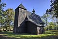
Wooden church in Grębień
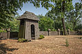
Bell bearer in Grebień

Wooden church in Popowice

Mill in Kępowizna

_ID_614788.jpg)


traffic
The most important roads are the national roads DK43 and DK43 , which run through the municipality from north to south. The nearest international airport is Łódź .
The nearest long-distance station is Wieluń Dąbrowa on the Herby – Oleśnica railway line . On the same route, the Pątnów Wieluński station and the Dzietrzniki stop exist on the municipality.
Web links
- Community website (Polish)
Individual evidence
- ↑ population. Size and Structure by Territorial Division. As of June 30, 2019. Główny Urząd Statystyczny (GUS) (PDF files; 0.99 MiB), accessed December 24, 2019 .
- ↑ a b regioset.pl: data on the municipality (Polish, accessed on May 27, 2020)
- ↑ German place names according to the order on place names change in Reichsgau Wartheland in the ordinance sheet of the Reich governor in Warthegau from May 18, 1943 (PDF; 1.8 MByte)
- ↑ NID : Informational directory of the list of monuments of the Łódź Voivodeship (as of March 31, 2016) (PDF, 500kB; Polish, accessed on March 23, 2020) pp. 109–110.
- ↑ Registered in the list of monuments of the Łódź Voivodeship under number 938 on December 30, 1967.
- ↑ Registered in the list of monuments of the Łódź Voivodeship under number 591-XIV-71 on November 19, 1953.
- ↑ Registered in the list of monuments of the Łódź Voivodeship under the number 950 on December 30, 1967.
- ↑ Registered in the list of monuments of the Łódź Voivodeship under number 345 on October 6, 1986.

Urban and rural municipalities Wieluń
Rural Communes of Biała | Czarnożyły | Konopnica | Mokrsko | Osjaków | Ostrówek | Skomlin | Pątnów | Wierzchlas