
Gmina Stary Dzierzgoń
| Gmina Stary Dzierzgoń | |||
|---|---|---|---|

|
|
||
| Basic data | |||
| State : | Poland | ||
| Voivodeship : | Pomerania | ||
| Powiat : | Sztum | ||
| Geographic location : | 53 ° 50 ′ N , 19 ° 24 ′ E | ||
| Residents : | see Gmina | ||
| Postal code : | 82-450 | ||
| Telephone code : | (+48) 55 | ||
| License plate : | GSZ | ||
| Gmina | |||
| Gminatype: | Rural community | ||
| Gmina structure: | 15 school offices | ||
| Surface: | 185.82 km² | ||
| Residents: | 3950 (June 30, 2019) |
||
| Population density : | 21 inhabitants / km² | ||
| Community number ( GUS ): | 2216032 | ||
| administration | |||
| Wójt : | Marek Turlej | ||
| Address: | Stary Dzierzgoń 71 82-450 Stary Dzierzgoń |
||
| Website : | www.starydzierzgon.pl | ||

The Gmina Stary Dzierzgoń is a rural municipality in the powiat Sztumski of the Pomeranian Voivodeship in Poland . Its seat is in the village of Stary Dzierzgoń ( German : Alt Christburg ). The municipality has an area of 185.8 km² with 3950 inhabitants (June 30, 2019).
history
In the years 1975-1998 the rural community belonged to the Elbing Voivodeship .
Community structure
The Gmina Stary Dzierzgoń includes fifteen districts ( German names ) with a Schulzenamt:
|
|
- Other localities
Other settlements in the municipality are:
|
|
Sights and cultural monuments
- Piotra i Pawła Church in Lubochowo (14th and 18th centuries)
- Church in Myślice (14th and 19th centuries)
- In the village of Przezmark are the ruins of the Prussian Mark Order Castle of the Teutonic Order .

Church in Lubochowo

Church in Myślice
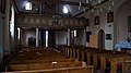
Inside the church in Myślice

Tower of the Order Castle
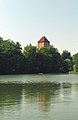
Tower and lake

Drawing of the tower


traffic
The Miswalde (Myślice) station was the junction of the routes to Elbing , Allenstein , Osterode , Riesenburg (other stations: Vorwerk, Alt Christburg, Münsterberg) and Marienburg until 1945 . After 1945, only the Olsztyn – Malbork line remained, the Małdyty – Myślice – Malbork section of which has not been used by passengers since 1999 and has now been completely closed.
Web links
- Rural Municipality Website (Polish)
Footnotes
- ↑ population. Size and Structure by Territorial Division. As of June 30, 2019. Główny Urząd Statystyczny (GUS) (PDF files; 0.99 MiB), accessed December 24, 2019 .
- ↑ The Historical Place Directory

Urban and rural communes: Dzierzgoń (Christburg) | Sztum (Stuhm)
Rural parishes : Mikołajki Pomorskie (Niklaskirchen) | Stary Dzierzgoń (Old Christburg) | Stary Targ (Altmark i. West Prussia)