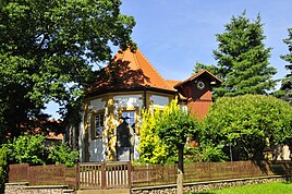
Gospiteroda
|
Gospiteroda
Rural community Georgenthal
Coordinates: 50 ° 53 ′ 17 " N , 10 ° 38 ′ 52" E
|
||
|---|---|---|
| Height : | 334 m | |
| Incorporation : | January 1, 1996 | |
| Incorporated into: | Leinatal | |
| Postal code : | 99887 | |
| Area code : | 03622 | |
|
Location of Gospiteroda in Thuringia |
||
|
Village church
|
||
The place Gospiteroda is a district of the rural community Georgenthal in the district of Gotha in Thuringia.
location
Gospiteroda is located about 8 kilometers (as the crow flies) southwest of the district town of Gotha on the northern roof of the Thuringian Forest , south of federal motorway 4 in the arable farming area in this area south of the Boxberg .
history
Gospiteroda was founded in the Middle Ages in the course of clearing construction. The place was mentioned for the first time in 1346 in a document from the Georgenthal monastery under the name Gotzbrechterode . Recently, May 1271 has been reported. In the middle of the village was a manor , the documents of which were destroyed in the Thirty Years War . Numerous stables and barns, the tavern and the brewery belonged to the estate.
A fountain in the manor was fed by a wooden pipe from the ponds southwest of Gospiteroda. During the Thirty Years' War , the landlord had the church built opposite the manor house. It was supposed to serve as a fortress and was probably connected to the manor house by an underground passage. This indicated subsidence in the earth, which, however, was carelessly filled in in the past. The landowners were the Imperial Counts of Hohenlohe , who in 1842 transferred inheritance jurisdiction to the Duchy of Saxony-Gotha and the administration of judges to the Tenneberg Justice Office . The estate was later sold to Messrs Wedekind. A plaque in the nave commemorates this family. The last owner of the estate, Fräulein von Wedekind, handed the estate over to a manager. After his death, the property fell to the community. It was distributed among 47 neighbors for a small sum. The village, which at that time consisted of around 200 inhabitants, lived from agriculture, cattle breeding and daily wages on the estate.
Until 1826 the place belonged to the Duchy of Saxe-Gotha-Altenburg , then, until the end of the monarchy to the Duchy of Saxe-Coburg and Gotha , until 1922 to the Free State or area of Gotha. After the Hohenlohes ceded patrimonial jurisdiction in 1848, the district of Ohrdruf of the Upper County of Gleichen was abolished. Its administrative powers were transferred in 1858 as part of the administrative reform carried out in the Duchy of Gotha to the newly founded District Office Ohrdruf , which existed until 1922.
The nuthatch was considered a notable guild. The Kleiben is the Thuringian half-timbered useful activity that was also a master of some citizens. The Gospiterodaer Kleiber moved out to the surrounding villages and filled the wooden framework with clay.
To this day, war and peace, times of need and times of prosperity have alternated. Probably the worst times in the last century were the two world wars 1914–1918 and 1939–1945 . Numerous soldiers did not return from the wars. During the Second World War, prisoners of war from France had to do forced labor for farmers since 1940 . After 1945 the population of the place rose sharply due to displaced persons . At the beginning of April 1945 US forces entered Gospiteroda, and the Red Army arrived at the beginning of July . The village thus belonged to the Soviet occupation zone (SBZ), from 1949 to the GDR.
From 1945 to 1960, the majority of the residents worked their fields as individual farmers. Since there were many small farms that fed their owners only right and poorly, many residents worked on the farms in the area. After the establishment of the LPG Einigkeit in 1960, agricultural plant and animal production was operated jointly. In 1973 a common dairy cattle facility was built. In the following years, the cooperatives in the vicinity merged. A plant production company was established in Schönau vor dem Walde and an animal production company in Ernstroda .
In the eastern part of the district, a large gravel pit has been built since the 1930s to meet the needs of the Reichsautobahn, which is currently under construction, and subsequently for the building materials industry in the Gotha district.
Attractions
- The current church was built in 1623 in the late Gothic style. The choir of the church, built in 1623, faces north. The tower has a stone barrel vault on the ground floor, now used as a sacristy. The double galleries are brightly painted. The church has no name.
- To the north of Gospiteroda is the extensive area of the Boxberg racecourse .
- There is an atonement cross on the eastern border with Emleben ( Lage ) . An information board next to it contains the text: "Here on July 27, 1628, during the Thirty Years' War, the farmer Max Rudloff from Ernstroda was killed by soldiers on his way to Gotha".
Individual evidence
- ^ Wolfgang Kahl : First mention of Thuringian cities and villages - A manual . Rockstuhl Verlag, Bad Langensalza 2010, ISBN 978-3-86777-202-0 .
- ^ Wolfgang Kahl: First mention of Thuringian towns and villages. A manual. Rockstuhl Verlag, Bad Langensalza, 2010, ISBN 978-3-86777-202-0 , p. 95
- ↑ U. Sareik, S. Ortmann, K. Sturm: Monuments of the Gotha district . Ed .: Council of the District of Gotha. August-Bebel Gotha printing works, Erfurt / Gotha 1987, p. 15 .

