Grafenberg (Neuffen-Vorberge)
| Grafenberg | ||
|---|---|---|
|
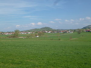
View from the west of the Grafenberg with small bedlings in the foreground On the right the higher Floriansberg . |
||
| height | 463.9 m above sea level NHN | |
| location | Baden-Württemberg | |
| Mountains | Neuffen foothills in the foothills of the central Swabian Alb | |
| Dominance | 1.6 km → SSO Floriansberg | |
| Notch height | 82 m | |
| Coordinates | 48 ° 34 '10 " N , 9 ° 18' 11" E | |
|
|
||
| rock | Basalt tuff | |
| Age of the rock | 17-11 Ma | |
The Grafenberg is a mountain near the village of the same name in the Grafenberg municipality in the Reutlingen district in Baden-Württemberg .
description
The village, which lies mainly south of the summit, almost completely surrounds the mountain top, only the western slope is free of buildings. The hilltop offers a northward view of the southern districts of Stuttgart on the Fildern .
From a natural perspective, the mountain, which belongs to the lower area of the Neuffen foothills of the foreland of the central Swabian Alb, is a rounded hump with a diameter of around one kilometer, which towers over its immediate surroundings about a hundred meters high. It is made of basalt tuff and is an erosion-resistant volcanic hardened stone at the site of a chimney of the Swabian volcano, which went extinct 11 million years ago in the Miocene .
About a height of 463.9 m above sea level. NHN reach the summit runs the watershed between the basins of the Autmut in the northeast and Erin in the southwest. The Ettwiesenbach , initially known as the Helfersbach , rises at the south - west foot , while the more distant Steidenbach collects the outflow on the west side , both of which run west and south-west to the Erms. The Reutenbach , which arises on the lower northern slope, as well as the Lailesbach, which initially rises from the summit on the eastern slope, and its Lauterbach receiving water, which begins a little further south-east from the highest point , drain northeast to the Autmut.
Landscape protection area
The summit area of the Grafenberg was designated as a 2.7 hectare landscape protection area on October 28, 1965 , it has the protection area number 4.15.129.
literature
- Topographic map 1: 25,000 Baden-Württemberg, as single sheet No. 7421 Metzingen
Individual evidence
LUBW
Official map with a suitable section and the layers used here: Grafenberg and the surrounding area
General introduction without default settings and layers: State Institute for the Environment Baden-Württemberg (LUBW) ( notes )
- ↑ Height according to black lettering on the background layer topographic map .
- ↑ Description according to the background layer topographic map .
Other evidence
- ^ Friedrich Huttenlocher , Hansjörg Dongus : Geographical land survey: The natural spatial units on sheet 170 Stuttgart. Federal Institute for Regional Studies, Bad Godesberg 1949, revised 1967. → Online map (PDF; 4.0 MB)
- ↑ Geology according to the layers for Geological Map 1: 50,000 on: Map server of the State Office for Geology, Raw Materials and Mining (LGRB) ( notes )
Web links
- Map of Grafenberg with surroundings on: State Agency for the Environment Baden-Württemberg (LUBW) ( information )
- Measuring table sheet 7421 Metzingen from 1901 in the Deutsche Fotothek

