
Big Belchen
| Big Belchen | ||
|---|---|---|
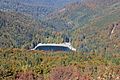
 Big Belchen from the west |
||
| height | 1424 m | |
| location | Haut-Rhin department , Grand Est region , France | |
| Mountains | Vosges | |
| Dominance | 67.3 km → Feldberg | |
| Notch height | 1072 m ↓ Burgundian Gate | |
| Coordinates | 47 ° 54 '3 " N , 7 ° 5' 55" E | |
|
||
| particularities | Highest mountain in the Vosges | |

The Große Belchen ( French Grand Ballon ) is 1424 meters high, the highest mountain in the Vosges . The mountain is also known under the name Sulzer or Gebweiler Belchen (French Ballon de Guebwiller ) after the nearest towns Soultz-Haut-Rhin (German Sulz ) and Guebwiller (German Gebweiler ) eight kilometers to the east. The mountain is located in the Ballons des Vosges Regional Nature Park .
The Vosges ridge road Route des Crêtes leads around the summit in the east and overcomes the pass between Le Markstein and Hartmannswillerkopf (French: Vieil Armand ) at an altitude of 1343 meters .
climate
The Grand Ballon is the coldest place in Alsace and has the highest wind speeds . The lowest measured temperature was -30.2 ° C on February 10, 1956, the highest 27 ° C on August 13, 2003. The snow depth in winter is usually over a meter, often 1.50 m. The temperature difference to the Rhine plain , measured near Mulhouse , fluctuates between 7 ° C and 10 ° C, and more in summer.
tourism

The mountain has slopes for alpine descents as well as cross-country trails. There is an inn at an altitude of 1,100 meters, a restaurant at 1,342 meters and a hotel at 1,351 meters. From the summit you first have a view of the Rhine plain with Mulhouse , Basel , Freiburg im Breisgau and Colmar , beyond that of the Black Forest and the Jura , and in favorable weather conditions of the Alpine chain from Säntis to Mont Blanc . The best visibility conditions are found in winter with high pressure and inversion weather conditions .
The summit of the Grand Ballon is accessible from the Vogesenkammstraße via three paths with a walk of around 15 minutes. Hiking trails lead downhill to the Lac du Ballon, among others .
On the top
In 1927, a memorial to the Blue Devils (Fr. Diables bleus), a mountaineering battalion in World War I , was erected and inaugurated by Raymond Poincaré . It was destroyed by the Germans in September 1940 and restored by the sculptor Bouret in October 1960.
A radar station has been on the summit since 1997 , which is used by civil aviation when approaching the airports of Strasbourg and Basel-Mulhouse . The station is surrounded by a viewing platform with orientation boards and was designed by Claude Vasconi . The center of the radome is on 1,435.5 meters.
The Great Belchen also has a meaning within the Belchen system : on May 1st, the Beltane holiday of the Celtic god Belenus , the sun rises just above him - as seen from Belchen in Alsace .

Large Belchen with radar station and Gebirgsjäger memorial

Radar station with viewing platform
Lake of the Great Belchen

Diables bleus monument


Panoramas


Web links
Individual evidence
- ↑ Dominances and celebrities according to Highrisepages.de ( Memento from October 19, 2014 in the Internet Archive )