
Gretenberg (Sehnde)
|
Gretenberg
City Sehnde
|
|
|---|---|
 |
|
| Height : | 80 m above sea level NN |
| Residents : | 134 (Dec 2018) |
| Incorporation : | March 1, 1974 |
| Postal code : | 31319 |
| Area code : | 05138 |
 The location of Gretenberg in the urban area of Sehnde
|
|
Gretenberg is a district of the city of Sehnde , southeast of Hanover .
history
Around 800 Franconian military colonists settled in the area around Gretenberg and belonged to the Great Free .
The oldest surviving document that mentions Gretenberg dates from 1230 .
In the course of the territorial reform, Gretenberg became a district of the municipality on March 1, 1974, today the town of Sehnde.
politics
Gretenberg does not have its own local council, but politically belongs to the Sehnde local council.
Culture and sights
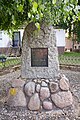
cenotaph

View into the village

Town view
_IMG_8278.jpg)
_IMG_8280.jpg)
_IMG_8277.jpg)
literature
- Friedrich Busch : Gretenberg in the " great outdoors ". A contribution to its history. In: Hannoversche Geschichtsblätter , 29th year, Hanover: Verlag von Theodor Schulzes Buchhandlung, 1926, pp. 145–2008
Web links
Commons : Gretenberg - collection of images, videos and audio files
Individual evidence
- ↑ Numbers - data - facts. sehnde.de, accessed on October 20, 2019 .
- ^ Federal Statistical Office (ed.): Historical municipality directory for the Federal Republic of Germany. Name, border and key number changes in municipalities, counties and administrative districts from May 27, 1970 to December 31, 1982 . W. Kohlhammer GmbH, Stuttgart / Mainz 1983, ISBN 3-17-003263-1 , p. 223 .