Haimar
|
Haimar
City Sehnde
|
|
|---|---|
| Coordinates: 52 ° 18 ′ 27 ″ N , 10 ° 2 ′ 55 ″ E | |
| Height : | 69 m above sea level NN |
| Residents : | 756 (Dec 2018) |
| Incorporation : | March 1, 1974 |
| Postal code : | 31319 |
| Area code : | 05138 |
|
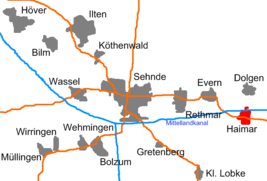
The location of Haimar in the urban area of Sehnde
|
|
Haimar is a district of the city of Sehnde , southeast of Hanover .
history
The name Haimar is probably derived from Heimbere or Heymbere for the raspberries in the formerly extensive forests around the place. A few kilometers further northeast is the Hämeler Forest , which was once part of the large northern forest . Today only a small part of the forest belongs to Haimar itself.
Around 800 the area around Haimar began to be settled with Frankish colonists and membership of the Great Free . The oldest surviving document that mentions Haimar dates back to 1117. At this time, Count Adalbert von Haimar moved to Wernigerode , whose family died out in 1429. Presumably he was enfeoffed with lands by Heinrich V in the Harz Mountains. In 1512, Haimar fell to the Principality of Lüneburg as a place within the Ilten District Bailiwick and suffered considerably during the Hildesheim collegiate feud . The neighboring village of Gilgen was subsequently abandoned in 1519. The residents settled in Haimar. In 1534 the Reformation began in Haimar.
In the course of the regional reform, Haimar became a district of the municipality on March 1, 1974, today the town of Sehnde.
religion

In church terms, the Haimar settlement initially belonged to the neighboring town of Evern . The parish seat came to Haimar as early as 1160 and a Romanesque church was built around 1200 . The counts of Wernigerode held the church patronage. In 1540 it was taken over by the Rethmar family of the von Rutenberg family. The original church structure changed many times over the centuries. This was due to renovations, storm damage and lightning strikes. The inventory suffered looting during the Thirty Years War . Extensive restoration work began in 1660. Since the small church became too small in the 18th century, today's baroque hall church St. Ulrich was built between 1784 and 1788 . The three-story west tower used to serve as orientation for travelers in the tree-poor landscape. The baroque interior design of the church is still there today. The villages of Dolgen and Evern also belong to the parish of Haimar. The Haimar parish has a parish relationship with the Rethmar parish. The common pastor of the two parishes has his residence in Rethmar.
politics
Haimar has a seven-member local council together with the districts of Dolgen and Evern.
The local mayor is Konrad Haarstrich.
coat of arms
Blazon : Divided by red and silver. Above the blue-armored golden lion of the "free", below two facing, rising, curved red trout.
Design: Carl Wenzel
Awarded by the President of the Province of Hanover on August 22, 1932.
Culture and sights
Economy and Infrastructure
Between 1898 and 1935 combined a tram of Üstra Haimar with Hannover. The route continued via Sehnde, Ilten , Höver and Anderten to Hanover. Today there is a connection to Hanover by a bus line. The Mittelland Canal lies north of Haimar . The B 65 runs through the village , it is a connection between Hanover and Peine.
literature
- Fritz Garbe: The home church. From the history of the Haimar parish. Burgdorf 1963/64
- Jan Habermann: The Counts of Wernigerode. Rulership profile, sphere of activity and closeness to the king of noble potentates in the northern Harz in the late Middle Ages. Norderstedt 2008, ISBN 978-3-8370-2820-1
- Dieter Rose Borsum, Günter Winkelmann: Haimar. From the past to the present. A village tells. Ed .: Realverband Haimar.
- Werner Walkling, Hanover: Haimar family book, places Haimar, Evern and Dolgen , 660 pages, softcover, self-published, Hanover, 2014
Web links
Individual evidence
- ↑ FIGURES - DATA - FACTS. www.sehnde.de, accessed on October 20, 2019 .
- ^ Federal Statistical Office (ed.): Historical municipality directory for the Federal Republic of Germany. Name, border and key number changes for municipalities, counties and administrative districts from May 27, 1970 to December 31, 1982 . W. Kohlhammer GmbH, Stuttgart and Mainz 1983, ISBN 3-17-003263-1 , p. 223 .
- ^ Local councilor Dolgen-Evern-Haimar
- ↑ Volkmar Tönnies: Riddle about coat of arms in the great outdoors solved . In: KLEEBLATT Vol. 37, No. 2, Heraldischer Verein "Zum Kleeblatt" , Hannover 2020, ISSN 2191-7965 , p. 62.

