
Great Bornhorster lake
| Great Bornhorster lake | ||
|---|---|---|

|
||
| Aerial view of part of the Großer Bornhorster See | ||
| Geographical location | Oldenburg , Lower Saxony , Germany | |
| Tributaries | Geestrand ditch | |
| Drain | Geestrandgraben → Wulfsgraft → Hunte | |
| Data | ||
| Coordinates | 53 ° 10 ′ 32 " N , 8 ° 16 ′ 34" E | |
|
||
| Altitude above sea level | 0 m | |
| surface | 48 ha | |
| length | 1 km | |
| width | 700 m | |
| scope | 4 km | |
|
particularities |
Retention basin |
|

The Große Bornhorster See is a quarry pond in the eastern urban area of Oldenburg (Oldenburg) not far from the border with the Wesermarsch district . However, it is already outside the denser urban development. The lake is located near the small towns of Groß Bornhorst and Klein Bornhorst to the west and south of it . The Hunte flows two kilometers south of the lake .
The owner of the body of water, which officially serves as a retention basin , is Moorriem - Ohmsteder Sielacht , which has leased the area to the city of Oldenburg.
The water area of the Großer Bornhorster See is 48 hectares and its circumference is around three kilometers. This makes it the largest lake in the city of Oldenburg and, after the Zwischenahner Meer, the second largest lake in the Oldenburg area. The lake is irregular in shape and measures almost 1000 meters in north-south direction, the east and west banks are up to 700 meters apart. In the southeast a small peninsula protrudes into the lake. It is 0 meters above sea level, i.e. at sea level.
400 meters north of the Großer Bornhorster See is the Kleine Bornhorster See, which is almost half the size . The federal motorway A 29 runs between the Großer Bornhorster See and Groß-Bornhorst at a distance of around 300 meters from the west bank. The waterway owes its origin to the ring of expressways around Oldenburg: The soil that was removed from it was required for the filling of the ramp to the Huntehochbrücke and the dams of the A 293 and the north bypass.
The Great Bornhorster See is located in the low-lying landscape protection area "Oldenburg-Rasteder Geestrand". To the east of it there is (old) marsh typical permanent grassland, which extends over five kilometers to the east and is largely under nature protection as Bornhorster hunt meadows . In the west, already 150 meters from the lakeshore and then beyond the motorway, the land rises as a Geest (i.e. the Oldenburger Geest ), so that both large and small Bornhorst are 12 to 15 meters above sea level. NN lie.
The Große Bornhorster See is not a swimming lake, but it is suitable for various leisure activities. The path around it is about four kilometers long. At the Großer Bornhorster See there is a jetty of the "Verein der Segelfreunde Oldenburg-Bornhorst eV (VSOB)".
The body of water is used by the Oldenburg sports fishing club as a fishing lake. In 2010, eels , perch , bream , pike , carp , roach , rudd , catfish and pikeperch were reported from the lake.
Picture gallery
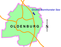
Location of the lake in the urban area of Oldenburg

Aerial view from a height of 500 m with boats, July 2010

Looking east


