Grumbach (Bad Langensalza)
|
Grumbach
City of Bad Langensalza
|
|
|---|---|
| Coordinates: 51 ° 3 ′ 56 ″ N , 10 ° 36 ′ 52 ″ E | |
| Height : | 294 (285-300) m above sea level NHN |
| Area : | 5.21 km² |
| Residents : | 246 (December 31, 2015) |
| Population density : | 47 inhabitants / km² |
| Incorporation : | April 1, 1993 |
| Postal code : | 99947 |
| Area code : | 03603 |
|
Location of Grumbach in Bad Langensalza
|
|
|
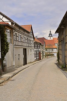
In the back alley
|
|
Grumbach is a district of the town of Bad Langensalza in the Unstrut-Hainich district in Thuringia .
location
Grumbach is located 5.23 km south-southwest of the spa town of Bad Langensalza (market church). The area north of the Steinberg (362.1 m above sea level) forms with the Große Harth (367.3 m above sea level), the Wieglebener Höhe ( Teufelsberg at 358 m above sea level) and the Ascharaer Höhe (312 m above sea level) the connection of the Hainich with the Fahner Höhe . Grumbach is a dead end village: the only road out of Grumbach leads to the neighboring village of Henningsleben . A well-developed agricultural path ( Schwichingsweg ) leads to the Harthhaus , 2.43 km to the west , a former customs house on the border of the Gotha and Unstrut-Hainich districts and today's destination on the B 84 . Another agricultural route connects the village with Wiegleben, 1.89 km to the south .
history
Grumbach was first mentioned in 1206.
The place has belonged to Bad Langensalza since April 1st, 1993.
District Mayor
The district mayor of Grumbach is Sebastian Schmidt.
Culture and sights
- The church of St. Vincentius dates from 1607. The previous building, which was located in the same place, was destroyed by a lightning strike.
Public facilities
The Harthknirpse kindergarten is located on the outskirts in a quiet location and in the immediate vicinity of gardens, fields and meadows. A large outdoor area with a playground, flower and vegetable garden as well as meadows and seating areas offer opportunities to play, discover and romp outside in all weathers.
Personalities
Sons and daughters of the place
- Oskar Trübenbach (1900 – unknown), politician (NSDAP), member of the Reichstag (1932–1945)
People connected to the place
- Wilhelm Ernst Möller (1827–1892), Lutheran theologian, church historian and university professor, pastor in Grumbach
literature
- Gustav Sommer, Heinrich Otte : Descriptive representation of the older architectural and art monuments of the Langensalza district. Ed .: Historical Commission of the Province of Saxony. Otto Hendel, Halle a. d. Saale 1879, p. 14, ( digital version [PDF; 6.2 MB]).
Web links
Individual evidence
- ^ Municipalities in Germany by area and population. (XLSX; 1.6 MB) See under: Thuringia, No. 15773 . In: Destatis website. Federal Statistical Office, December 31, 1992, accessed on November 2, 2019 .
- ↑ a b c Information on the Grumbach district. In: Website City of Bad Langensalza. December 31, 2015, accessed March 1, 2019 .
- ^ Federal Statistical Office: Municipalities 1994 and their changes since January 1, 1948 in the new federal states. Metzler-Poeschel, Stuttgart 1995, ISBN 3-8246-0321-7 .


