Gwabl
|
Gwabl ( scattered houses ) locality cadastral community Gwabl |
||
|---|---|---|
|
|
||
| Basic data | ||
| Pole. District , state | Lienz (LZ), Tyrol | |
| Pole. local community | Ainet | |
| Coordinates | 46 ° 52 '59 " N , 12 ° 40' 21" E | |
| height | 984 m above sea level A. | |
| Residents of the village | 105 (January 1, 2020) | |
| Area d. KG | 15.79 km² | |
| Post Code | 9951 | |
| Statistical identification | ||
| Locality code | 16765 | |
| Cadastral parish number | 85002 | |
| Counting district / district | Ainet (70702 000) | |
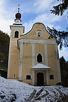
 Catholic branch church of the Visitation of Mary |
||
| Source: STAT : index of places ; BEV : GEONAM ; TIRIS | ||
Gwabl is a scattered settlement and a cadastral community of the municipality of Ainet . The village is located high above the Iseltal on the southern slopes of the Schober group in the Lienz district in Tyrol , Austria and has 105 inhabitants (as of January 1, 2020).
geography
The buildings in the village of Gwabl are scattered over the slopes of the Lassniger Bichl and the Zutruger Kreuz. The village includes the farms Ausersteiner, Badstuber, Eder, Frotschnig, Innersteiner, Jester, Köfele, Mittermair, Obermair, Rainer, Thaler and Untermair, in the middle of which is the Catholic branch church of the Visitation of Mary. Gwabl also includes the Gussenstall single layer, the Hochschoberhütte and the alpine pastures Ausersteinerede, Ederalm, Innersteineralm, Leibnitzalm, Mittermairalm, Ochsenwaldhütte, Raineralm, Thaleralm and Untermairgscherz.
history
The place name Gwabl was mentioned in documents in 1206 as in monte Quabel . The origin of the name cannot be clearly proven.
Gwabl was an independent municipality until 1939. After the National Socialists came to power, the communities of Ainet, Gwabl and Schlaiten were combined to form the community of Ainet. While the community of Schlaiten regained its independence in 1949, Gwabl and Alkus remained with Ainet. In 1890 Gwabl consisted of 18 houses with 139 residents. By 1923 the number of buildings increased to 27 while the population decreased to 123. In 2001 the group comprised 25 buildings with 25 households and 118 inhabitants. There were 17 agricultural and forestry facilities.
Culture and sights
- Gwabl pilgrimage church of the Visitation of the Virgin Mary
- Station path to the pilgrimage church
Web links
Individual evidence
- ↑ Statistics Austria: Population on January 1st, 2020 by locality (area status on January 1st, 2020) , ( CSV )
- ^ Hubert Bergmann: Slavic in the name of the East Tyrolean communities Ainet and Schlaiten. Verlag Edition Praesens, Vienna 2005, p. 186 (Supplements to Austrian naming research; Volume 5)
- ^ Kk statistical Central Commission (ed.): Special-Orts-Repertorium von Tirol. Revised based on the results of the census of December 31, 1890. Vienna 1893
- ^ Federal Statistical Office (ed.): Directory of Austria. Edited on the basis of the results of the census of March 7, 1923. Wien 1930, S. Tir. 4th
- ^ Austrian Central Statistical Office (Hrsg.): Ortsverzeichnis 1981. Tirol. Vienna 1984, p. 122
