Hünstein (Gladenbacher Bergland)
| Chicken stone | ||
|---|---|---|
|
View from Wurstberg ( 407.1 m ) south-south-east over Holzhausen to the Allbergen : to the left the Staufenberg ( 468 m ), to the right of it the Hünstein with the Allberg ( 527.7 m ), which is slightly towering above it , which is also the Daubhaus ( 551, 8 m ) adjoins; far right of the bridges |
||
| height | 503.7 m above sea level NHN | |
| location | near Holzhausen am Hünstein ; District of Marburg-Biedenkopf , Hesse ( Germany ) | |
| Mountains | Gladenbacher Bergland | |
| Coordinates | 50 ° 48 '10 " N , 8 ° 32' 4" E | |
|
|
||
| particularities | - Ringwall Hünstein - Hünstein Tower ( AT ) |
|
The Hünstein is 503.7 m above sea level. NHN high mountain in the Gladenbacher Bergland near Holzhausen am Hünstein in the Marburg-Biedenkopf district in central Hesse . The Hünstein ring wall and an observation tower are located on it .
geography
location
The Hünstein rises in the east of the Bottenhorn plateau in the Allbergen , to which the Allberg ( 527.7 m ) and Staufenberg ( 468 m ) belong and which, with the Daubhaus, are a maximum of 551.8 m high. The summit of the mountain in the Lahn-Dill-Bergland nature park is 150 m north of the border between the municipality of Dautphetal and the city of Gladenbach - around 1.4 km south-southeast of Holzhausen am Hünstein . On the north-eastern flank of the mountain, the Folkerbach rises as a tributary of the Dautphe flowing to the west . Somewhat east-south-east lies the source of the Allna beyond the Staufenberg .
Natural allocation
The Hünstein belongs to the natural spatial main unit group Westerwald (No. 32), in the main unit Gladenbacher Bergland (320) and in the subunit Lahn-Dill-Bergland (320.0) to the natural area Bottenhorn plateau (320.01).
Ringwall Hünstein
The Hünstein ring wall is located on the mountain , which, like the 850 m south-southwest ring wall on the Daubhaus , is assigned to the Hallstatt or Latène times .
Hünsteinurm
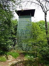
The Hünstein Tower, which is almost 20 meters north and slightly below the summit, is a 10 m high observation tower that was built in 1930 by members of the Upper Hessian Mountain Association as a wooden structure. It is currently (as of 2014) partly overlooked by surrounding trees, but the view falls between the treetops or over them to Holzhausen and east past it to Mornshausen with Dautphe to the north . In the lower part of the tower there is a shelter, from which a wooden staircase with 32 steps leads to the 6.6 m high covered viewing platform .
Traffic and walking
North past the Hünstein from Holzhausen to federal road 453 in northwest-southeast direction, district road 74. On this road there is a parking lot near the southeast exit of the village ( ⊙ ), from where the mountain can be hiked on mostly forest paths and paths. Another starting point for hikes is the Hirzenhecke refuge , 250 m west of the mountain , which can be reached from county road 74 via a paved spur road. The Lahn-Dill-Bergland-Path (stage 4) on the section from Gladenbach to Caldern runs directly over the Hünstein .
Web links
Individual evidence
- ↑ a b Map services of the Federal Agency for Nature Conservation ( information )
- ^ Heinrich Janke: Inventory of the prehistoric and early historical monuments of Hesse, Volume II, Der Kreis Biedenkopf , pp. 18/19, panels 7A / 7B, R. Habelt Verlag, Bonn, 1973
- ^ "Holzhausen am Hünstein, Marburg-Biedenkopf district" (with information on the "Ringwall on the Hünstein"). Historical local dictionary for Hessen. (As of March 4, 2014). In: Landesgeschichtliches Informationssystem Hessen (LAGIS).
- ^ Association history of the OHGV branch association Holzhausen / Hünstein e. V. , on ohgv.de
- ↑ Lahn-Dill-Bergland-Path, stage 4 , on wanderkompass.de


