
Rade de Cherbourg

The French term Rade de Cherbourg ( German Roads of Cherbourg ) stands for the entire port of Cherbourg-en-Cotentin . It includes several ports that have been developed over centuries and the largest artificial roadstead in the world for centuries (now Qatar), consisting of inner and outer roads (Petite and Grande Rade). Today it is number 2 of the world's largest shipping lines. The port is important as a naval base and ferry port to Ireland.
The port facilities on the English Channel are in front of the core city of Cherbourg (today through extensions Cherbourg-en-Cotentin ) and cover an area of approximately 1500 hectares. The artificial roadstead of Cherbourg, which was expanded in the 18th century, includes the marine base as well as a trading, fishing, ferry and yacht port (Port de Plaisance). For a long time, especially at the time of the passenger steamer, it was the starting point for the North American passages as an overseas port next to Southampton .
Fortifications and expansion of the roadstead
The construction of the roadstead began in 1783. In 1853 the construction of the Digue Centrale (central embankment) was completed, which was provided with three fortresses in 1860. Then from 1890 to 1895 the Digue de l'Est (east dam) was built four kilometers off the coast. The Digue du Large (dam in the sea) is 3640 meters long, with an average width of 100 meters at the base and a width of 12 meters at the top. The height reaches 27 meters. In total, all dams are more than 6 km long.
The Passe de l'Est (east opening) is 700 m wide, while the Passe de l'Ouest (west opening) is 1.1 km wide. Their maximum depth reaches 13 meters at low tide.
The rocky subsoil of the roadstead consists of slate from the Neoproterozoic .
history

Cherbourg has been a fortress since antiquity and has had a castle that protects the Cotentin coast since the 10th century . In the 17th century, Sébastien Le Prestre de Vauban began building the fortifications before they were demolished shortly afterwards on the orders of the French Minister of War François Michel Le Tellier de Louvois .
The construction of a military port in Cherbourg has long been considered. When numerous ships of the Admiral de Tourville were destroyed in 1692 , thus proving that the defense of the city had great deficiencies, Louis XVI began. with the construction work. To this end, he had a committee convened under the auspices of Suffren in 1776 , whose members included Dumouriez , who later became the governor of Cherbourg, and La Bretonnière. This committee was charged with choosing a port to protect the English Channel coast , choosing between Cherbourg, Ambleteuse and Boulogne-sur-Mer . According to the report by La Bretonnière, Cherbourg was chosen because only here was it possible to protect 80 warships. La Bretonnière considered building a four-kilometer dam between Île Pelée and Pointe de Querqueville. Dumouriez and Decaux proposed a shorter, straighter dam between Île Pelée and Pointe du Hommet with a single opening.
Ultimately, La Bretonnière prevailed with his proposal. Then the construction method was discussed: Decaux pursued the idea of building and sinking boxes, while La Bretonnière wanted to sink warships weighed down with stones. Louis-Alexandre de Cessart's request to build conical boxes was finally granted.
Starting in 1783, the three engineers Louis-Alexandre de Cessart, La Bretonnière and Joseph Cachin worked on the four-kilometer-long dam in succession for a total of 70 years. The first conical box using the Cessart method was sunk on June 6, 1784, one kilometer from Île Pelée . The roadstead was then filled with 300 to 400 ships that operate between the port of Becquet and the roadstead to load the stones. The first four boxes, however, were not able to withstand the storms.
On June 22, 1786 Louis XVI traveled. to the province to inquire about the progress of the project and to watch the sinking of the ninth box. This would be his only trip to the province.
In 1788, however, it had to be determined that the Cessartian method did not work. The idea of La Bretonnière was used again despite the revolutionary mood and although large sums of money had already flowed into the project. Nevertheless, Dumouriez and Cessart left Cherbourg between 1789 and 1790.
In 1790, the financial donations for the project were canceled, which is why La Bretonnière had to resign two years later. Despite the law of August 1, 1792, which provided for the construction of the military port, construction work was suspended for ten years.
In 1802, Napoléon ordered that work on the dam be resumed using the La Bretonnière method. The middle of the dam was set up so that it could accommodate cannons. By decree of the 25th Germinal , year XI (1803), et Cachin was commissioned to build a military port, which was inaugurated on August 27th. At the same time, an arsenal was built in Cherbourg . These measures should help with a planned incursion into England. In 1803 Cherbourg, protected from English attacks, became the home port of privateers.
The construction work on the Digue Centrale , which was interrupted again between the years 1813 and 1832, was only stopped under Napoleon III. Completed in 1853, while the Digue de l'Ouest and the Digue de l'Est continued to be built until 1895. The basins Charles X and Napoléon III. were finally inaugurated on August 25, 1829 in the presence of the Dauphin and on August 7, 1858 in the presence of the imperial couple. During the Third Republic , the construction work was finally completed: the digue du Hommet (1899–1914) and digue des Flamands (1921–1922) were built, creating the petite rade (small roadstead).
Charles Maurice Cabart Danneville created an opening in digue Collignon in the east to enable fishermen to reach the roadstead quickly in bad weather. Nowadays this opening is called passe Cabart-Danneville .
The luxury liner Titanic began her maiden voyage to New York on April 10, 1911, coming from Southampton, here as the last port on the continent. A specially built and stationed tender ship in the design of the shipping company, the Nomadic , resulted in a change of passengers and freight. 22 people had only booked the canal passage. On April 11th, around noon, the Titanic anchored again off Queenstown in Ireland , where mainly emigrants boarded the third class. Only seven passengers destined for Ireland disembarked. On the 15th the well-known catastrophic iceberg collision occurred.
The roadstead at Cherbourg could not be completely destroyed by the German military in 1944. After fierce fighting , it and the city were captured and liberated by the Allies on June 26, 1944. After just 15 days of clearing work in the harbor basins, they will begin to be used for the invasion. Cherbourg remains the strategically most important supply port for the troops in western Europe until the end of the war. The museum in the Fort du Roule - musée de la Liberation reminds of what happened during the Second World War (on the 117 m high mountain of Cherbourg).
Fortresses
- Away you Homet
- Fort de l'île Pelée (on the Île Pelée )
- Fort Chavagnac
- Fort de l'Est
- Fort de l'Ouest (with lighthouse )
- Fort central
- Fort de Querqueville
- Fort des Flamands
- Le Fort de la Montagne du Roule, at times also a German fortress, today also Musée de la Liberation (founded in 1954)
gallery
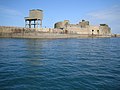
Fort Central

Fort de Chavagnac
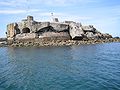
Fort de l'Est, destroyed during World War II

Fort de l'Ouest

Digue de l'Ouest de la grande Rade

View of the roadstead from the Querqueviller cemetery

View of the roadstead from the Querqueviller cemetery

Entrance to the Fort de Querqueville

Les casemates du Fort de Querqueville


Movie
- Video on Youtube Cherbourg vu du fort du Roule
literature
- Bazan: Quels sont les hommes qui ont exercé le plus d'influence sur la création d'un arsenal maritime à Cherbourg et en particulier quelle part doit être attribuée à Vauban dans les projets relatifs à la fermeture de la rade. In: Séances du congrès scientifique de France, tenu à Cherbourg en septembre 1860. Cherbourg, Auguste Mouchel, 1860.
- Yves Murie: La Digue qui a fait Cherbourg. Cherbourg, Isoète, 2007. ISBN 978-2-913920-59-0 (French)
- Frédéric Patard, Michelle Baudry: La Montagne et le fort du Roule . Guide Unica near Lecaux, 2014, 83 pages. ISBN 2-912980-06-2 (French)
- Jacqueline Vastel: Le Fort de la Montagne du Roule , in À la découverte de Cherbourg , ville de Cherbourg, 1992. (French)
Web links
- La grande rade de Cherbourg Website Tourist Office (French).
- Rade de cherbourg website Wikimanche (French)
- Les forts de la rade de Cherbourg (French)
- Les forts de la rade de Cherbourg , Netmarine
- Forts de la grande rade de Cherbourg
- La grande rade , ville de Cherbourg-Octeville
- Situation de la Passe Cabart-Danneville
- Plan de Cherbourg et sa rade 1900, Carto-mondo.fr
Individual evidence
- ↑ Guide géologique Normandie -Maine. Edition DUNOD. 2nd edition. Page 82. ISBN 2-10-050695-1