
Hardy (Arkansas)
| Hardy | |||
|---|---|---|---|
 Main Street in historic city center (2013) |
|||
| Location in Arkansas | |||
|
|||
| Basic data | |||
| State : | United States | ||
| State : | Arkansas | ||
| County : | Sharp , Fulton | ||
| Coordinates : | 36 ° 19 ′ N , 91 ° 29 ′ W | ||
| Time zone : | Central ( UTC − 6 / −5 ) | ||
| Residents : | 772 (as of 2010) | ||
| Population density : | 55.1 inhabitants per km 2 | ||
| Area : | 14 km 2 (approx. 5 mi 2 ) of which 14 km 2 (approx. 5 mi 2 ) are land |
||
| Height : | 115 m | ||
| Postcodes : | 72525, 72529, 72542 | ||
| Area code : | +1 870 | ||
| FIPS : | 05-29920 | ||
| GNIS ID : | 0049856 | ||
| Mayor : | Nina Thornton | ||

Hardy is a city and a resort in Arkansas , United States , which is for the most part in Sharp County and with its northern part in Fulton County . In 2010 it had 772 inhabitants.
Geography and traffic
Hardy is north of Arkasas in the foothills of the Ozark Mountains on the Spring River and on the railway line of the former St. Louis - San Francisco Railway (now BNSF ) between Memphis and Springfield . The urban area is crossed by US Highway 62 on a joint route with US Highway 412 . US Highway 63 also runs on this route from Imboden to Hardy, but it branches off to the north in the west of the city. Arkansas Highway 175 joins the US Highway when coming from the north on the eastern edge of the city and branches off to Cherokee Village on the western edge .
history
The settlement emerged in 1883 with the construction of the Kansas City, Springfield, and Memphis Railroad . It was named after the Batesville railroad builder James A. Hardy and laid out by Walter Clayton on an area of 600 acres (243 hectares). Since the name Hardy was accepted by the post office as a delivery address for the railway workers in this area, efforts by residents to rename the place after a nearby stream in Forty Islands were unsuccessful. Originally the city was supposed to offer services for travelers. On July 12, 1894, the place received municipal rights. The great distance to Evening Shade , the then seat of the county administration, meant that in 1894 Sharp County was divided into two districts and Hardy became the administrative seat of the northern district. After the construction of a court building and the establishment of administrative structures, the population rose to 347 people by 1900.
Memphis doctor George Gillespie Buford and his wife were held up in Hardy in 1908 because of a broken train. After a trip to Wahpeton Hill south of town, they were so impressed by the beautiful area that they bought land for a summer home the following year. After acquiring more land in the Jordan and East Wahpeton Hills area, they had ten more holiday homes built there in 1912 and called the resulting summer resort the Wahpeton Inn . In 1932 LL Ward from Blytheville opened a second summer resort, which he called Rio Vista . Summer camps for the youth were also set up: in 1916 Miramichee was built by the YWCA and Kia Kima by the Boy Scouts , the Girl Scouts built Camp Kiwani in 1920 . Tourism led to an economic boom in the city. Around 1930 the city had 508 inhabitants, but from July to September around 1000 visitors a day. Although these were welcome, they meant considerable effort for the residents. In addition to the railway connection, there were also bus connections to and from Hardy.
With increasing car traffic and the expansion of the state road network, the focus of tourism shifted from long-term to weekend visits. Sommerfrische Wahpeton's vacation homes were sold individually, and homes for senior citizens were built in 1955. Hardy became an important place for senior residences. The establishment of Cherokee Village also led to an increase in tourism to the Ozarks. With the improved road conditions, the dual administrative structure in the county became obsolete, and in 1963 Ash Flat became the seat of Sharp County. Hardy train station closed in 1970, after which several shops moved off the main street. A flood in 1982 accelerated this process. Instead of the long-established shops, antique and craft shops have established themselves.
Development of the population
| year | 1900 | 1910 | 1920 | 1930 | 1940 | 1950 | 1960 | 1970 | 1980 | 1990 | 2000 | 2010 | 2015 |
|---|---|---|---|---|---|---|---|---|---|---|---|---|---|
| population | 347 | 329 | 399 | 508 | 721 | 599 | 555 | 692 | 643 | 538 | 578 | 772 | 759 |
| source |
Culture
In 1968 the Arkansaw Traveler Folk Theater was founded in Hardy with the aim of preserving the culture of the Ozarks.
The TV series Clash of the Ozarks of Discovery Channel plays in Hardy.
Several buildings in Hardy, including some residential and original cottages, as well as the town center and the area around the cemetery, have been listed as cultural landmarks on the National Register of Historic Places .
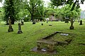
Historic cemetery

Sherman Bates House
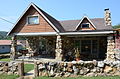
Thomas Walker House
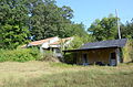
Web Long House and former motel


proof
- ↑ a b Census of Population and Housing . Census.gov. Archived from the original on November 15, 2015. Retrieved June 4, 2015.
- ^ A b c d G. Wayne Dowdy: Hardy (Sharp County) . The Encyclopedia of Arkansas History and Culture. 29th November 2016.
- ↑ Annual Estimates of the Resident Population for Incorporated Places: April 1, 2010 to July 1, 2015 . Retrieved July 2, 2016.
- ^ Clash of the Ozarks . Discovery Channel & Discovery.com.
- ^ National Register of Historic Places. Arkansas - Sharp County . American Dreams Inc ..