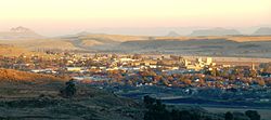
Harrismith (South Africa)
| Harrismith | ||
|---|---|---|
|
|
||
| Coordinates | 28 ° 17 ′ S , 29 ° 8 ′ E | |
| Basic data | ||
| Country | South Africa | |
| free State | ||
| District | Thabo Mofutsanyana | |
| ISO 3166-2 | ZA-FS | |
| local community | Maluti-a-Phofung | |
| height | 1630 m | |
| Residents | 27,869 (2011) | |
| founding | 1849 | |
|
Part of Harrismith
|
||
Harrismith is a city in the South African province of Free State . It is located in the Maluti-a-Phofung parish in the Thabo Mofutsanyana district .
geography
In 2011 Harrismith had 27,869 residents. North of the city center is the township Intabazwe ( isiZulu , German: Flat mountain) with around 65,000 inhabitants. The Wilge River flows through Harrismith . The city is located immediately west of the 2,377 meter high Table Mountain Platberg (German: Flat Mountain). There are more table mountains and hardships in the area . The Drakensberg lies south of Harrismith . The city is located in the east of the Free State Province exactly halfway between Johannesburg and Durban .
history
Harrismith was founded in 1849. The city was named after the British Sir Henry George Wakelyn Smith , most commonly called Sir Harry Smith. He was then governor of the Cape Colony and had encouraged the Voortrekkers not to leave Natal . Originally, the city was to emerge 25 kilometers to the west, where Aberfeldy is today. There were too few springs there, so that the city was built in January 1850 at its present location. 24 years later, Harrismith received city rights . During the gold rush in Kimberley Harrismith was an important way station on the road to the port of Durban . During the First and Second Boer Wars , the city and its surroundings were the scene of several battles. The majority of the population was of British origin, but citizens of the then Boer- ruled Orange Free State . In the suburb Intabazwe, also called 42nd Hill, lived at the time of apartheid , especially Basotho . Later, many Zulu moved there, so that the population groups are approximately the same size.
Economy and Transport
Harrismith is a transportation hub. The national road N3 (Johannesburg – Durban) runs through Harrismith, the N5 begins here and heads west, where it joins the N1 at Winburg . Highway Junction at the junction of the N5 from the N3 is the largest rest area in South Africa. Harrismith is located on the Ladysmith - Bethlehem railway line , which came from Ladysmith to Harrismith in 1892, but was not expanded for several years. In Harrismith, a branch line to Warden used to branch off to the northwest , later only to Kaffirstad. Long-distance traffic is now carried out with buses. To the north of the city there is an airfield with a 1200-meter-long runway, which is not served by scheduled services ( IATA code: HRS).
Harrismith is the center of one of the five South African districts where wool is produced. There is a large wool and cotton processing plant in the city.
The Ingula pumped storage plant is being built near the city .
Attractions
- Harrismith Town Hall , built of sandstone and brick in 1907 , is a national monument.
- Harrismith Wildflower Gardens was founded in 1967 as a botanical garden and contains around one fifth of the flora of the Drakensberg.
- The Platberg is the scene of the annual Platberg Mountain Race , a particularly difficult long-distance run . The running distance is 15 kilometers. In 1922 this run was first carried out on the basis of a bet by a British major .
- Near the city there are several, including from San -made rock paintings .
- Sterkfontein Dam , the third largest reservoir in South Africa, is located around 20 kilometers southwest of Harrismith. It was built for the water supply of today's Gauteng Province . The water was mainly pumped into the basin from the province of KwaZulu-Natal via a mountain sill. Thanks to the supply of Gauteng by the Lesotho Highlands Water Project , the water from the Sterkfontein Dam is hardly needed anymore . The 180 km² Sterkfontein Dam Nature Reserve is located on the reservoir , where antelopes and vultures can be found.
Personalities
- Harry Hart (1905–1979), South African athlete, born in Harrismith
Others
90 kilometers away in KwaZulu-Natal is the town of Ladysmith, named after Sir Harry Smith's wife.
Web links
- Tourist information about Harrismith and the surrounding area
- Tourist information on Harrismith (English)
- History Harri Smith up to the Boer Wars (English)
Individual evidence
- ↑ 2011 census , accessed November 26, 2013
- ↑ a b Information on Intabazwe (English), accessed on December 4, 2010
- ↑ Information about a project in Intabazwe; from cache, otherwise the homepage will appear ( Memento from April 8, 2008 in the Internet Archive ) (English), accessed on December 3, 2010
- ↑ Intazabwe apparently belongs to Harrismith; the population of the city is given elsewhere as around 96,000
- ↑ Information on Highway Junction ( Memento of the original from December 7, 2010 in the Internet Archive ) Info: The archive link was automatically inserted and not yet checked. Please check the original and archive link according to the instructions and then remove this notice. (English), accessed December 3, 2010
- ↑ a b Information about Harrismith ( Memento from August 25, 2014 in the Internet Archive ) (English), accessed on December 3, 2010
- ↑ Information on the airfield , accessed on January 23, 2016


