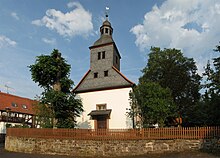
Hatzbach
|
Hatzbach
City of Stadtallendorf
Coordinates: 50 ° 52 ′ 34 ″ N , 9 ° 0 ′ 59 ″ E
|
|
|---|---|
| Height : | 252 (249–275) m above sea level NHN |
| Area : | 3.56 km² |
| Residents : | 575 approx. |
| Population density : | 162 inhabitants / km² |
| Incorporation : | December 31, 1971 |
| Postal code : | 35260 |
| Area code : | 06428 |
Hatzbach is a district of Stadtallendorf in the central Hessian district of Marburg-Biedenkopf .
geography
Hatzbach is located in the transition area between the Gilserberger Heights and the Neustädter Sattel , about 5.5 km (as the crow flies ) north of the Stadtallendorf capital. Neighboring places are Speckswinkel (Neustadt) in the east-southeast, Erksdorf (Stadtallendorf) in the south-southeast and Wolferode (Stadtallendorf) in the north-west. North-northeast of the Hatzbach at an altitude of 249 to 275 m rises the whetstone ( 358.5 m ) belonging to the Gilserberger heights . In the village, the small Wildenbach flows into the Wohra tributary Hatzbach .
History and appearance
The place was first mentioned in a document in 1262. Hatzbach Castle was built in the 14th century at the latest . The castle and village were given to the Knoblauch zu Hatzbach as a fief by the Counts of Ziegenhain around this time . A free aristocratic manor owned by Knoblauch zu Hatzbach is now privately owned. The Hatzbacher church was built around 1490. In Hatzbach there is a community center and a municipal kindergarten .
On December 31, 1971, Hatzbach was incorporated into the town of Allendorf, district of Marburg (then the official name of the town).
traffic
State road 3071 (Wolferode – Hatzbach – Speckswinkel) runs through Hatzbach , from which the L 3290 branches off to the east- south-east of the village in the direction of Erksdorf (and then on to Stadtallendorf) and on the south-western outskirts of the village, district road 14 in the direction of Emsdorf . Local public transport is ensured by a city bus connection to Stadtallendorf.
Personalities
- Hans Caspar von Knoblauch zu Hatzbach (1719–1793), Hessian major general
Web links
- District Hatzbach. In: Internet presence. Stadtallendorf
- Hatzbach. Local history, information. In: www.hatzbach.de. Private website
- Hatzbach, Marburg-Biedenkopf district. Historical local dictionary for Hessen. In: Landesgeschichtliches Informationssystem Hessen (LAGIS).
- Literature on Hatzbach in the Hessian Bibliography
Individual evidence
- ^ Hatzbach, Marburg-Biedenkopf district. Historical local dictionary for Hessen. (As of March 15, 2016). In: Landesgeschichtliches Informationssystem Hessen (LAGIS).
- ↑ Population on the Stadtallendorf website , accessed in March 2013
- ^ Federal Statistical Office (ed.): Historical municipality directory for the Federal Republic of Germany. Name, border and key number changes in municipalities, counties and administrative districts from May 27, 1970 to December 31, 1982 . W. Kohlhammer, Stuttgart / Mainz 1983, ISBN 3-17-003263-1 , p. 402 .
