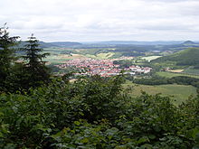
Heiligenstadt city forest
| Heiligenstadt city forest | ||
|---|---|---|
|
In the background the Heiligenstadt city forest southeast of Uder |
||
| Highest peak | NN (near Forsthaus) ( 467.5 m above sea level ) | |
| location | Heilbad Heiligenstadt , Eichsfeld district , Thuringia | |
| part of | Western Obereichsfeld , Ringgau – Hainich – Obereichsfeld – Dün – Hainleite | |
| Classification according to | Handbook of the natural spatial structure of Germany | |
|
|
||
| Coordinates | 51 ° 20 '58 " N , 10 ° 7' 56" E | |
| rock | Shell limestone , red sandstone on the edge | |
| surface | 14 km² | |
The Heiligenstadt city forest is a small, completely wooded ridge south of the Leine near Heilbad Heiligenstadt in Obereichsfeld , Thuringia ( Germany ), up to 467.5 m high . Until 2009 he was the namesake of a 3.066 hectare landscape protection area of the same name, which, in addition to the core ridge, also included the northwest of the Dün as far as the Geisleden district. It has now been integrated into the LSG Obereichsfeld and with it into the Eichsfeld-Hainich-Werratal Nature Park .
location
The Heiligenstädter Stadtwald is a northern branch of the northwestern side ridge of the Upper Eichsfeld . It is bounded clockwise by the Lutter in the west, its receiving water Leine between Uder and Heilbad Heiligenstadt in the north and the lower reaches of the Geislede and its tributary, the Pferdebach, in the east. To the south, the landscape in the Heiligenstadt district of Kalteneber merges smoothly into the unforested Obereichsfeld ridge on the 494 m high Ebersberg , in the extreme southeast the forest extends to the 515.9 m high waiting mountain .
The forest area is crossed by the state road L 2022 Heiligenstadt– Bernterode ( Forsthaus ) centrally in a north-south direction, parallel to this the L 2023 Uder – Kalteneber ( Lutterstraße ) flanks the ridge in the Luttertal in the west and the L 1006 Heiligenstadt– Flinsberg ( Flinsberger Road ) in the Pferdebachtal in the east.
The continuous forest covers 18.3 km², up to just over the Pferdebachtal, with a maximum length of 7.5 km in a south-east-north-west direction and 4 km wide. The actual ridge accounts for around 14 km² (maximum 6 km long and 3 km wide).
mountains
The highest elevations are:
- NN (467.5 m) north of the forester's house
- The swamp (467.2 m), a southern branch
- Brandkopf (464.2 m), east of Lutter
- Iberg (453.2 m), south of Heiligenstadt
- Old head (448.2 m), north of Lutter
- Schüttenkopf (also Struthberg) (447.8 m), southwest of Heiligenstadt
- Elisabethhöhe (430.5 m), a northwestern branch
- Dänersberg (approx. 440 m), south of the Long Valley
Worth seeing
The wooded mountain region offers numerous hiking opportunities and excursion destinations:
- Ibergswarte
- Meridian stone on the Iberg
- Bobbin lace
- historical ramparts on the Elisabethhöhe
- Recreation Center "Nine Wells"
- Swedish Cross
- Forester's house
Viewpoints in the western Eichsfeld and the border region to Hesse and Lower Saxony arise from the Elisabethhöhe and the Maienwand. At the foot of the Elisabethhöhe there are some rock formations and a small cave ( dwarf cave ), which are already in the red sandstone of the Leinetal.
Individual evidence
- ↑ TLUG: Protected areas in the Eichsfeld , map is clickable
- ↑ a b Map services of the Federal Agency for Nature Conservation ( information )
- ↑ Measurement by polygon in Google Earth
Web links
- Leine-Werra Nature Park , accessed on August 14, 2011.


