Elisabethhöhe (Obereichsfeld)
| Elisabethhöhe | ||
|---|---|---|
|
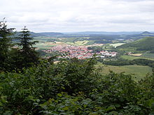
View over Uder to the Schüttenkopf with the Elisabethhöhe |
||
| height | 430.5 m above sea level NHN | |
| location | near Heilbad Heiligenstadt ; Obereichsfeld , Thuringia ( Germany ) | |
| Mountains |
Heiligenstädter Stadtwald , Western Obereichsfeld |
|
| Coordinates | 51 ° 21 '43 " N , 10 ° 6' 4" E | |
|
|
||
| rock | Shell limestone | |
The Elisabethhöhe is 430.5 m above sea level. NHN high mountain of the western upper area . It is located near Heilbad Heiligenstadt in the Thuringian district of Eichsfeld .
geography
location
The Elisabethhöhe is a northwestern branch of the Schüttenkopf (also Struthberg) ( 447.8 m ) and rises in the north of the Eichsfeld district in the Eichsfeld-Hainich-Werratal Nature Park . The summit is located immediately southwest of Heilbad Heiligenstadt and east of Uder in the Heiligenstadt city forest . The mountain plateau falls on three sides with a steep shell limestone layer, to the north and northeast to the valley of the Leine and west and southwest to the valley of the Lutter .
Natural allocation
The Elisabethhöhe belongs to the natural spatial main unit group Thuringian Basin (with edge plates) (No. 48), in the main unit Ringgau – Hainich – Obereichsfeld – Dün – Hainleite (483) and in the subunit Westliches Obereichsfeld (483.2) to the natural area Kalteneberer step edge area (483.20) . To the north, the landscape falls into the main unit group Weser-Leine-Bergland (No. 37) and in the main unit Unteres Eichsfeld (375) into the sub-unit Eichsfelder Hügelland 375.1.
view
On the plateau there is a lookout point to the west with a view of the Leinetal near Uder. In the distance you can see the elevations of the Hennefeste ( 446.4 m ), the sand forest ( 477.2 m on the sharpness), the Dransfeld city forest ( 492.5 m at the Hohen Hagen) and the Rusteberg ( 397.6 m ) . To the north in the direction of Rengelrode there is another lookout point with a view of the Eichsfeld hill country .
Worth seeing
The completely forested Elisabethhöhe is an interesting hiking area, starting in Uder, on the outskirts of Heiligenstadt or from the forest car park on Landesstraße 2022 (Holzweg) to Kalteneber . Destinations worth seeing are:
- the way of the cross to the Elisabeth chapel
- Lookout point with rest area and information board for the view
- the area of the old castle below the Elisabethhöhe with the dwarf cave
- early medieval ramparts and moats
Origin of name
The first written mentions can be found from 1671 in front of Ilsabeth Hohl and in 1749 at Elisabethol . The original name ending -hohl could stand for cave, depression or hollow path; the current ending -höhe is only documented from 1805. The personal name Elisabeth could be derived from the saint's name.
history
On the Elisabethhöhe there is a pre-Franconian rampart and escape castle. The system had a side length of 160–210 meters and was secured on the access side from the south by two ramparts. The ramparts and moats are still partially recognizable today. It has not been proven whether the “Alte Burg” area below the Elisabethhöhe is related to this complex. There is evidence of the Heiligenstädter Landwehr at the Elisabethhöhe for the year 1749 : at the Landwehr at Elisabethol . In 1846–1848 the Way of the Cross from Heiligenstadt up to the chapel was renewed. In 1943 a Reich training camp for the Hitler Youth was opened at the foot of the hilltop . Today there is an allotment garden.
Individual evidence
- ↑ a b Map services of the Federal Agency for Nature Conservation ( information )
- ^ Hans-Jürgen Klink: Geographical land survey: The natural space units on sheet 112 Kassel. Federal Institute for Regional Studies, Bad Godesberg 1969. → Online map (PDF; 6.9 MB)
- ↑ a b Tobias Rohner: The microtoponyms of the district of Heiligenstadt. FSU Jena 2006, pp. 31-32.
- ↑ Micheal Gockel: The German royal palaces. Volume 2 Thuringia Vandenhoeck & Ruprecht Göttingen 1984, p. 200
- ↑ Jürgen Backhaus: Heimatforscher: There was a Nazi training camp near Heiligenstadt. in: Thüringische Landeszeitung (Eichsfeld) from August 14, 2012 [1]
Web links
- Iberg hike to the Maienwand and Elisabethhöhe (with map), on heilbad-heiligenstadt.de (PDF; 3.92 MB)


