
Heinävesi
| coat of arms | map |
|---|---|

|

|
| Basic data | |
| State : |
|
| Landscape : | South Savo |
| Administrative community : | Savonlinna |
| Geographical location | 62 ° 26 ' N , 28 ° 38' E |
| Surface: | 1,319.12 km² |
| of which land area: | 1,030.39 km² |
| of which inland waterways: | 288.73 km² |
| Residents : | 3,329 (Dec 31, 2018) |
| Population density : | 3.2 inhabitants / km² |
| Municipality number : | 090 |
| Language (s) : | Finnish |
| Website : | www.heinavesi.fi |
Heinävesi [ ˈhɛi̯nævɛsi ] is a municipality in Finland .
It is located in the South Savo region . The municipality has 3329 inhabitants (December 31, 2018) on an area of 1319.1 km² with water areas of 288.7 km².
Part of the Kolovesi National Park is located in the municipality .
The Varistaipale Canal is the canal with the greatest height difference in Finland.
The Orthodox women's monastery Lintula has existed since 1895 .

Map of the municipality

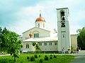
The church of Heinävesi , 1891, Josef Stenbäck
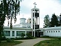
Church of the Uusi Valamo Monastery
Church of the Lintula Convent

Varistaipale Canal


Personalities
- Mira Potkonen (* 1980), boxer
Web links
Individual evidence
- ↑ Maanmittauslaitos (Finnish land surveying office): Suomen pinta-alat kunnittain January 1, 2010 . (PDF; 199 kB)
- ↑ Statistical Office Finland: Table 11ra - Key figures on population by region, 1990-2018
Enonkoski | Heinävesi | Hirvensalmi | Joroinen | Juva | Kangasniemi | Mikkeli | Mäntyharju | Pertunmaa | Pieksämäki | Puumala | Rantasalmi | Savonlinna | Sulkava