Pertunmaa
| coat of arms | map |
|---|---|

|

|
| Basic data | |
| State : |
|
| Landscape : | South Savo |
| Administrative community : | Mikkeli |
| Geographical location | 61 ° 30 ′ N , 26 ° 29 ′ E |
| Surface: | 454.19 km² |
| of which land area: | 374.49 km² |
| of which inland waterways: | 79.70 km² |
| Residents : | 1,713 (Dec. 31, 2018) |
| Population density : | 4.6 inhabitants / km² |
| Municipality number : | 588 |
| Language (s) : | Finnish |
| Website : | www.pertunmaa.fi |
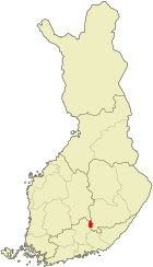
Pertunmaa is a municipality in southeastern Finland . It is located around 170 kilometers northeast of the capital Helsinki in the middle of the Finnish lake district .
The municipality lies on the historical border between the Savo and Häme landscapes . The first written mention of Pertunmaa comes from 1559; the land register of the parish of Sysmä registered seven houses in the settlement for this year. In 1595 Pertunmaa became part of the newly established Mäntyharju parish and remained so for centuries. Pertunmaa only achieved communal independence in 1926, after the local parish had previously separated from the Mäntyharjus parish after a long dispute.
The parish church of the parish was originally the old wooden church in Hartola, 30 kilometers away . After the new granite church Hartolas was consecrated in 1913, there was no longer any need for the old church, so it was sold to Pertunmaa, dismantled and rebuilt in Pertunmaa.
Since the construction of State Road 5 , which crosses the south of the municipality, the town of Kuortti, next to the church village of Pertunmaa, has become the focus of the settlement. The municipal administration is also located in Kuortti. The municipality also includes the villages of Mansikkamäki, Nipuli, Lihavanpää, Joutsjärvi, Ruorasmäki, Koirakivi, Paaso, Hölttä, Vastamäki, Hartosenpää, Kuhajärvi ,ky Karttamäki, Sydänmaä and.
The school in Pertunmaa maintains a partnership with the middle school in Knetzgau .
Web links
Individual evidence
- ↑ Maanmittauslaitos (Finnish land surveying office): Suomen pinta-alat kunnittain January 1, 2010 (PDF; 199 kB)
- ↑ Statistical Office Finland: Table 11ra - Key figures on population by region, 1990-2018